Sulphur Well Historic District
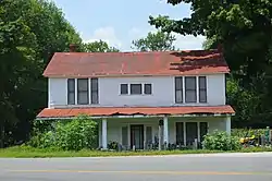
The Sulphur Well Historic District is an 81 acres (33 ha) historic district in Sulphur Well, Kentucky which was listed on the National Register of Historic Places in 1998.[1]
Sulphur Well Historic District | |
 | |
  | |
| Location | Roughly by Wister Wallace Rd., S fork of the Little Barren R., Mitchell-Edwards Rd., and KY 70, Sulphur Well, Kentucky |
|---|---|
| Coordinates | 37°06′03″N 85°38′04″W |
| Area | 81 acres (33 ha) |
| Built | 1860 |
| Architectural style | Bungalow/craftsman |
| NRHP reference No. | 98000932[1] |
| Added to NRHP | August 14, 1998 |
It is roughly bounded by Wister Wallace Rd., the southern fork of the Little Barren River, Mitchell-Edwards Rd., and Kentucky Route 70. The listing included 37 contributing buildings, a contributing structure, and five contributing sites.[1]
According to its nomination, "Sulphur Well is a good example of a. small rural mineral water town in western Kentucky that developed between 1860 and 1949."[2]
References
- "National Register Information System". National Register of Historic Places. National Park Service. July 9, 2010.
- Donna G. Logsdon (March 11, 1998). "National Register of Historic Places Registration: Sulphur Well Historic District". National Park Service. Retrieved April 5, 2018. With 37 photos.
| Topics | |
|---|---|
| Lists by state |
|
| Lists by insular areas | |
| Lists by associated state | |
| Other areas | |
| Related | |
| |
This article is issued from Wikipedia. The text is licensed under Creative Commons - Attribution - Sharealike. Additional terms may apply for the media files.