Sylvan Lake, Michigan
Sylvan Lake is a city in Oakland County in the U.S. state of Michigan. The population was 1,720 at the 2010 census.[6] As a northern suburb of Metro Detroit, Sylvan Lake is about 20 miles (32 km) northwest of the city of Detroit. The city also shares a northeastern border with the city of Pontiac.
Sylvan Lake, Michigan | |
|---|---|
| City of Sylvan Lake | |
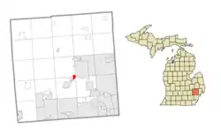 Location within Oakland County | |
 Sylvan Lake Location within the state of Michigan | |
| Coordinates: 42°36′41″N 83°19′43″W | |
| Country | United States |
| State | Michigan |
| County | Oakland |
| Settled | 1824 |
| Incorporated | 1921 (village) 1947 (city) |
| Government | |
| • Type | Mayor–council |
| • Mayor | Aron Lorenz |
| • Manager | John Martin |
| Area | |
| • City | 0.85 sq mi (2.20 km2) |
| • Land | 0.52 sq mi (1.35 km2) |
| • Water | 0.33 sq mi (0.86 km2) |
| Elevation | 955 ft (291 m) |
| Population | |
| • City | 1,720 |
| • Estimate (2019)[3] | 1,858 |
| • Density | 3,573.08/sq mi (1,380.74/km2) |
| • Metro | 4,296,250 (Metro Detroit) |
| Time zone | UTC-5 (Eastern (EST)) |
| • Summer (DST) | UTC-4 (EDT) |
| ZIP code(s) | 48320 (Keego Harbor) |
| Area code(s) | 248 |
| FIPS code | 26-77860[4] |
| GNIS feature ID | 1614519[5] |
| Website | Official website |
With a land area of 0.51 square miles (1.32 km2), Sylvan Lake is the fourth-smallest city by land area in the state after Clarkston, Petersburg, and Keego Harbor. Sylvan Lake borders Keego Harbor on the west.
Geography
According to the United States Census Bureau, the city has a total area of 0.82 square miles (2.12 km2), of which 0.51 square miles (1.32 km2) is land and 0.31 square miles (0.80 km2) (37.8%) is water.[7]
Demographics
| Historical population | |||
|---|---|---|---|
| Census | Pop. | %± | |
| 1930 | 799 | — | |
| 1940 | 1,041 | 30.3% | |
| 1950 | 1,165 | 11.9% | |
| 1960 | 2,004 | 72.0% | |
| 1970 | 2,219 | 10.7% | |
| 1980 | 1,949 | −12.2% | |
| 1990 | 1,884 | −3.3% | |
| 2000 | 1,735 | −7.9% | |
| 2010 | 1,720 | −0.9% | |
| 2019 (est.) | 1,858 | [3] | 8.0% |
| U.S. Decennial Census[8] | |||
2010 census
As of the census[2] of 2010, there were 1,720 people, 809 households, and 474 families living in the city. The population density was 3,372.5 inhabitants per square mile (1,302.1/km2). There were 864 housing units at an average density of 1,694.1 per square mile (654.1/km2). The racial makeup of the city was 94.5% White, 2.2% African American, 0.3% Native American, 0.7% Asian, 0.5% from other races, and 1.7% from two or more races. Hispanic or Latino of any race were 1.5% of the population.
There were 809 households, of which 26.9% had children under the age of 18 living with them, 45.9% were married couples living together, 8.7% had a female householder with no husband present, 4.1% had a male householder with no wife present, and 41.4% were non-families. 34.9% of all households were made up of individuals, and 9.5% had someone living alone who was 65 years of age or older. The average household size was 2.13 and the average family size was 2.76.
The median age in the city was 44.8 years. 20.1% of residents were under the age of 18; 4.2% were between the ages of 18 and 24; 26% were from 25 to 44; 33.7% were from 45 to 64; and 16% were 65 years of age or older. The gender makeup of the city was 49.3% male and 50.7% female.
2000 census
As of the census[4] of 2000, there were 1,735 people, 826 households, and 465 families living in the city. The population density was 3,305.8 per square mile (1,288.2/km2). There were 855 housing units at an average density of 1,629.1 per square mile (634.8/km2). The racial makeup of the city was 95.39% White, 1.21% African American, 0.46% Native American, 0.81% Asian, and 2.13% from two or more races. Hispanic or Latino of any race were 1.10% of the population.
There were 826 households, out of which 20.5% had children under the age of 18 living with them, 46.4% were married couples living together, 6.7% had a female householder with no husband present, and 43.7% were non-families. 36.6% of all households were made up of individuals, and 9.8% had someone living alone who was 65 years of age or older. The average household size was 2.09 and the average family size was 2.76.
In the city, the population was spread out, with 18.0% under the age of 18, 4.4% from 18 to 24, 36.9% from 25 to 44, 25.8% from 45 to 64, and 14.9% who were 65 years of age or older. The median age was 40 years. For every 100 females, there were 96.5 males. For every 100 females age 18 and over, there were 94.7 males.
The median income for a household in the city was $71,875, and the median income for a family was $90,931. Males had a median income of $70,526 versus $45,341 for females. The per capita income for the city was $48,744. About 0.6% of families and 2.0% of the population were below the poverty line, including none of those under age 18 and 1.8% of those age 65 or over.
Education
A portion is in the Pontiac School District.[9]
About 10% of Sylvan Lake is within the West Bloomfield School District.[10]
References
- "2019 U.S. Gazetteer Files". United States Census Bureau. Retrieved July 25, 2020.
- "U.S. Census website". United States Census Bureau. Retrieved 2012-11-25.
- "Population and Housing Unit Estimates". United States Census Bureau. May 24, 2020. Retrieved May 27, 2020.
- "U.S. Census website". United States Census Bureau. Retrieved 2008-01-31.
- U.S. Geological Survey Geographic Names Information System: Sylvan Lake, Michigan
- "Race, Hispanic or Latino, Age, and Housing Occupancy: 2010 Census Redistricting Data (Public Law 94-171) Summary File (QT-PL), Sylvan Lake city, Michigan". United States Census Bureau. Retrieved August 19, 2011.
- "Michigan: 2010 Population and Housing Unit Counts 2010 Census of Population and Housing" (PDF). 2010 United States Census. United States Census Bureau. September 2012. p. 37 Michigan. Retrieved May 1, 2020.
- "Census of Population and Housing". Census.gov. Retrieved June 4, 2015.
- Murray, Diana Dillaber. "Law being proposed could dissolve Pontiac schools, other struggling districts." Oakland Press. June 12, 2013. Retrieved on May 7, 2014. "Pontiac school district spreads from Pontiac into portions of seven surrounding communities including Auburn Hills, Sylvan Lake, Lake Angeles and townships of Bloomfield, Orion, Waterford and West Bloomfield."
- "District Overview." (Archive) West Bloomfield School District. Retrieved on September 8, 2013.