Berkley, Michigan
Berkley is a city in Oakland County in the U.S. state of Michigan. It is a northern suburb of Detroit located along the Woodward Corridor (M-1) in southeastern Oakland County. The population was 14,970 as of the 2010 census.
Berkley, Michigan | |
|---|---|
| City of Berkley | |
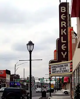 Downtown Berkley along Twelve Mile Road | |
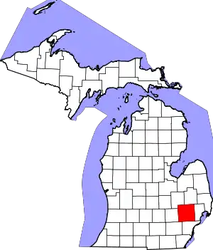
 Location within Oakland County | |
 Berkley Location within the state of Michigan | |
| Coordinates: 42°30′11″N 83°11′01″W | |
| Country | United States |
| State | Michigan |
| County | Oakland |
| Incorporated | 1923 (village) 1932 (city) |
| Government | |
| • Type | Council–manager |
| • Mayor | Dan Terbrack |
| • Manager | Matthew Baumgarten |
| Area | |
| • City | 2.62 sq mi (6.77 km2) |
| • Land | 2.62 sq mi (6.77 km2) |
| • Water | 0.00 sq mi (0.00 km2) |
| Elevation | 686 ft (209 m) |
| Population | |
| • City | 14,970 |
| • Estimate (2019)[5] | 15,366 |
| • Density | 5,876.10/sq mi (2,268.87/km2) |
| • Metro | 4,296,250 (Metro Detroit) |
| Time zone | UTC-5 (EST) |
| • Summer (DST) | UTC-4 (EDT) |
| ZIP code(s) | 48072 |
| Area code(s) | 248 |
| FIPS code | 26-07660[6] |
| GNIS feature ID | 0621157[7] |
| Website | Official website |
History
Prior to settlement, the land which would become Berkley consisted largely of dense forests and some isolated pockets of swampland.[8] Many in the region deemed the areas north and west of Detroit as uninhabitable or impassible due to the harshness of the swamps beyond Detroit, but as adventurers pushed out through the interminable swamp, they found beautiful scenery beyond the wet prairie of Northern Wayne County. As it became well known that there was "fine farming country" to the north and west of Detroit great excitement was raised and people began to flock to what was then all known as Royal Oak.[9] Land in what would later become Berkley began being sold to farmers who cut down forests and otherwise prepared the land for farming. By the 1840s. Berkley contained a great number of dairy farms. The 1910s brought significant growth to the area with the completion of the Highland Park Ford Plant. As farms were sold and turned into subdivisions, there was pressure to formally incorporate the land. In 1923, Berkley was incorporated as a village. At the time Elmer Cromie had named the road that ran through his farm Berkley and the "Berkley School" was then under construction, so the name Berkley was chosen for the village.[10]
The Wall Street Crash of 1929 brought growth in Berkley to a halt. Roughly 90% of the 5,558 residents in Berkley lost their jobs when the market crashed.[11] Within a year, the city's population was dropping and in 1932 voters chose to incorporate their Village into a City to gain more oversight over taxes and other issues facing the community. In the 1940s, suburbanization and the post-war boom economy drove significant development in the area. The current Berkley High School was built in 1949 and the city reached a population peak of 23,375, in the 1960.[12]
Culture
12 Mile Road
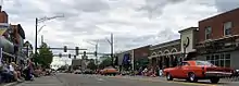
Downtown Berkley stretches along 12 Mile Road between Greenfield Road and Coolidge Highway, and along Coolidge Highway between 12 Mile Road and 11 Mile Road. Downtown Berkley is home to many restaurants, boutiques, clothing stores, and retail shops. Berkley's municipal offices, public library, and public safety headquarters are located near the intersection of 12 Mile Road and Coolidge Highway. Downtown Berkley hosts an annual Art Bash, which drew roughly 10,000 people to the city's commercial sector in 2016.[13] The art bash brings local artists from all over Michigan to sell art from photographs, garden art, jewelry and pottery to clothing accessories and paintings. Local stores and shops also participate in the festivities holding sidewalk sales. The city is an active participant in the annual Woodward Dream Cruise, a popular classic car showcase in the Metro Detroit area. Berkley hosts a classic car parade Downtown, called the Berkley CruiseFest. It holds the festivities one day before the official date of the Dream Cruise,[14] and has done so every year since 1995.[15]
In addition to the Downtown festivities, the city holds an annual Summerfest and Winterfest through the city Parks and Recreation department and partnerships with volunteers and community organizations.[16] The City of Berkley is home to many neighborhood parks and a large central community center, which is located on Catalpa Drive, just east of Anderson Middle School. For decades Berkley Parks and Recreation operated an ice arena at their central facility, but this was closed in 2016 due to a coolant leak in the facility.[17] As of June 2017 the city was investigating redevelopment options for the future of the facility which may include a pool or an ice arena, but not both.[18]
The city of Berkley was planned and exists as an inner-ring suburb of Detroit. The majority of its streets connect on a grid pattern and typical lots are small by suburban standards. This is viewed by the residents as fostering a tight-knit community. This has led to the community becoming an increasingly popular suburb, being among the healthiest housing markets in Michigan and the United States,[19] but despite this Berkley is still considered affordable by Time Inc's Money Magazine, which rated Berkley as the 28th-best place to live for the money, in the United States[20] due to its "small town feel" within Metro Detroit and its "easily walkable downtown".
Geography
Berkley lies within Southeastern Oakland County, bordered by Woodward Avenue on the east, Webster Road on the North, Greenfield Road on the west, and 11 Mile Road on the south. The southern border of the city is 3 miles north of the Detroit city limits, which are bounded by Eight Mile Road. Berkley is intersected by 12 Mile Road and Coolidge Highway, and though no Interstates run through the city, Interstate 75 and Interstate 696 are major thoroughfares near the city. According to the United States Census Bureau, the city has a total area of 2.62 square miles (6.79 km2), all land.[21]
Demographics
| Historical population | |||
|---|---|---|---|
| Census | Pop. | %± | |
| 1930 | 5,571 | — | |
| 1940 | 6,406 | 15.0% | |
| 1950 | 17,931 | 179.9% | |
| 1960 | 23,275 | 29.8% | |
| 1970 | 21,879 | −6.0% | |
| 1980 | 18,637 | −14.8% | |
| 1990 | 16,960 | −9.0% | |
| 2000 | 15,531 | −8.4% | |
| 2010 | 14,970 | −3.6% | |
| 2019 (est.) | 15,366 | [5] | 2.6% |
| U.S. Decennial Census[22] | |||
2010 census
As of the census[4] of 2010, there were 14,970 people, 6,594 households, and 3,896 families residing in the city. The population density was 5,713.7 inhabitants per square mile (2,206.1/km2). There were 6,933 housing units at an average density of 2,646.2 per square mile (1,021.7/km2). The racial makeup of the city was 93.3% White, 3.0% African American, 0.3% Native American, 1.3% Asian, 0.1% Pacific Islander, 0.3% from other races, and 1.8% from two or more races. Hispanic or Latino of any race were 1.8% of the population.
There were 6,594 households, of which 28.0% had children under the age of 18 living with them, 45.7% were married couples living together, 9.7% had a female householder with no husband present, 3.6% had a male householder with no wife present, and 40.9% were non-families. 33.6% of all households were made up of individuals, and 10.5% had someone living alone who was 65 years of age or older. The average household size was 2.27 and the average family size was 2.95.
The median age in the city was 37.9 years. 21.4% of residents were under the age of 18; 6.1% were between the ages of 18 and 24; 33.7% were from 25 to 44; 27.3% were from 45 to 64; and 11.3% were 65 years of age or older. The gender makeup of the city was 47.9% male and 52.1% female.
2000 census
As of the census[6] of 2000, there were 15,531 people, 6,678 households, and 4,020 families residing in the city. The population density was 5,925.5 per square mile (2,288.8/km2). There were 6,833 housing units at an average density of 2,607.0 per square mile (1,007.0/km2). The racial makeup of the city was 96.09% White, 0.70% African American, 0.24% Native American, 1.03% Asian, 0.01% Pacific Islander, 0.40% from other races, and 1.53% from two or more races. Hispanic or Latino of any race were 1.31% of the population.
There were 6,678 households, out of which 27.7% had children under the age of 18 living with them, 48.1% were married couples living together, 9.2% had a female householder with no husband present, and 39.8% were non-families. 32.5% of all households were made up of individuals, and 11.3% had someone living alone who was 65 years of age or older. The average household size was 2.32 and the average family size was 3.01.
In the city, the population was spread out, with 22.8% under the age of 18, 6.4% from 18 to 24, 38.2% from 25 to 44, 19.7% from 45 to 64, and 12.9% who were 65 years of age or older. The median age was 36 years. For every 100 females, there were 93.1 males. For every 100 females age 18 and over, there were 88.8 males.
The median income for a household in the city was $57,620, and the median income for a family was $66,968. Males had a median income of $50,276 versus $36,624 for females. The per capita income for the city was $27,504. About 2.5% of families and 3.6% of the population were below the poverty line, including 4.0% of those under age 18 and 3.8% of those age 65 or over.
Schools
The Berkley School District operates in almost all of Berkley, all of Huntington Woods, and the north section of Oak Park. The school district includes four elementary schools (Angell, Burton, Pattengill, and Rogers.), one Kindergarten-8th grade school (Norup International), one middle school (Anderson), and one high school (Berkley High School). From 2008 to 2016, Berkley High School has been named by Newsweek on its list of 1,000 Best High Schools in the nation.[23][24] In 2008, it ranked among the top six in Michigan, and in 2017 The Washington Post rated it as one of the most challenging high schools in the nation, making it one of three Oakland County high schools to earn the distinction.[25] Norup became an International Baccalaureate Candidate school this year implementing the Primary Years Programme (PYP) and Middle Years Programme (MYP) for all students. Homeowners in the first block west of Woodward and in the first five streets north of Eleven Mile Road are serviced by the Royal Oak Public Schools.[26]
A former elementary school, Avery, was converted into the school district office and is now known as Avery Center. Avery is one of three campuses (with Tyndall and Magnolia) housing the Berkley School District's Building Blocks program for infants through pre-school. The program is nationally accredited, one of among only 8% accredited centers in the country.[27]
Our Lady of La Salette School was established in 1943.[28] Initially 100 students attended. Beginning in 1947, the school building opened in three phases, with completion in 1953.[29] In the 1960s it had over 1,000 students, its highest number ever. From the 2008-2009 school year until the 2012-2013 school year the student body numbers declined by 47%, with the final student count at 73. It closed in 2013.[28] There was a proposal to convert the building into apartments, but the Berkley city council rejected it in 2018.[30]
Notable people
- Curtis Armstrong, actor (Booger in the Revenge of the Nerds movies; Herbert Viola on Moonlighting, Ahmet Ertegün in Ray); graduated from Berkley High School
- Joseph Bruce, rapper and producer (Insane Clown Posse); born in Berkley
- Marshall Crenshaw, singer, songwriter, and actor (Someday, Someway); portrayed Buddy Holly in La Bamba); graduated from Berkley High School (1971)
- Bruce Flowers, pro basketball player selected by Cleveland Cavaliers 26th overall in 1979 NBA Draft, had most of his success overseas, playing for Italian squads; graduated from Berkley High School
- J. Fred Lawton, lyricist, poet, and businessman; closely associated with University of Michigan, produced "Varsity," which became a University of Michigan fight song, and played football under legendary coach Fielding H. Yost; lived in Berkley
- Sander Levin, U.S. Congressman, first Chairman of Berkley Democratic Club, played instrumental role in building Berkley Public Library
- Owain Phyfe, musician and producer; lived in Berkley
- Jim Seymour, wide receiver for Notre Dame and Chicago Bears; born in Berkley
- Jim Starlin, comic book artist and novelist; graduated from Berkley High School (1967)
- Rob Tyner, lead singer for proto-punk band MC5; lived and died in Berkley
See also
References
- "CITY GOVERNMENT - Berkley, Michigan". Infomi.com. Retrieved April 30, 2015.
- "City of Berkley, MI". BerkleyMich.org. Retrieved April 30, 2015.
- "2019 U.S. Gazetteer Files". United States Census Bureau. Retrieved July 25, 2020.
- "U.S. Census website". United States Census Bureau. Retrieved November 25, 2012.
- "Population and Housing Unit Estimates". United States Census Bureau. May 24, 2020. Retrieved May 27, 2020.
- "U.S. Census website". United States Census Bureau. Retrieved January 31, 2008.
- U.S. Geological Survey Geographic Names Information System: Berkley, Michigan
- "Vegetation Circa 1800 of Oakland County, Michigan" (PDF). Michigan Department of Natural Resources, Michigan State University. Retrieved September 2, 2017.
- "History of Oakland County, Michigan | Page 196". L.H. Everts and Co. Retrieved September 2, 2017.
- "Where Berkley Got Its Name | City of Berkley" (PDF). City of Berkley. Retrieved May 31, 2017.
- "History of Berkley". Michigan State University: Michigan History. Retrieved May 31, 2017.
- "City of Berkley | Master Plan" (PDF). City of Berkley. Retrieved May 31, 2017.
- "Up to 10,000 people expected for Berkley Art Bash". Daily Tribune. Retrieved June 2, 2017.
- "2015 Berkley Cruisefest Parade". BerkleyMich.org. Retrieved February 8, 2016.
- "Berkley CruiseFest and Classic Car Parade revving up Friday night". Oakland Press. Retrieved June 2, 2017.
- "Parks and Recreation". BerkleyMich.org. Retrieved June 2, 2017.
- "Coolant leak shuts down Berkley Ice Arena, city seeking redevelopment proposals". Fox 2 Detroit. Retrieved June 2, 2017.
- "Berkley using survey results to decide future of Community Center, ice arena". Daily Tribune. Retrieved June 2, 2017.
- "2 Michigan cities are among America's top 20 hottest housing markets". MLive.com. Archived from the original on October 5, 2017. Retrieved June 2, 2017.
- "Best Places to Live 28. Berkley Mich". Time. Retrieved June 2, 2017.
- "US Gazetteer files 2010". United States Census Bureau. Archived from the original on July 2, 2012. Retrieved November 25, 2012.
- "Census of Population and Housing". Census.gov. Retrieved June 4, 2015.
- "Berkley High School Named one of Newsweek's Best High Schools". Archived from the original on January 31, 2013. Retrieved July 24, 2012.
- "Did your Michigan high school make Newsweek's list of the best?". Retrieved June 2, 2017.
- "America's Most Challenging High Schools". Retrieved June 2, 2017.
- "Pupil Enrollment Projection Study Report 2010-2014" (PDF). Royal Oak Schools. Archived from the original (PDF) on July 20, 2011.
See Map on Page 4
- "About the District". Archived from the original on July 4, 2013. Retrieved October 16, 2014.
- Ellis, Leslie (March 25, 2013). "Our Lady of La Salette School in Berkley to Close". Huntington Woods-Berkley Patch. Retrieved May 2, 2020.
- "History". Our Lady of La Salette Catholic Church. Retrieved May 2, 2020.
- Koury, Mike (July 25, 2018). "Berkley council rejects application for La Salette School apartment project". Woodward Talk. C & G Newspapers. Retrieved May 2, 2020.
External links
| Wikimedia Commons has media related to Berkley, Michigan. |
Places adjacent to Berkley, Michigan | |
|---|---|