Tainai
Tainai (胎内市, Tainai-shi) is a city located in Niigata Prefecture, Japan. As of 31 December 2020, the city had an estimated population of 28,495 in 10,821 households,[1] and a population density of 110 persons per km2 (288/sq mi). The total area of the city was 264.89 square kilometres (102.27 sq mi).
Tainai
胎内市 | |
|---|---|
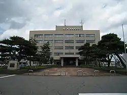 Tainai City Hall | |
 Flag  Seal | |
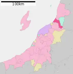 Location of Tainai in Niigata Prefecture | |
 Tainai | |
| Coordinates: 38°3′34.9″N 139°24′37.2″E | |
| Country | Japan |
| Region | Chūbu (Kōshin'etsu) (Hokuriku) |
| Prefecture | Niigata |
| Area | |
| • Total | 264.89 km2 (102.27 sq mi) |
| Population (December 31, 2020) | |
| • Total | 28,495 |
| • Density | 110/km2 (280/sq mi) |
| Time zone | UTC+9 (Japan Standard Time) |
| Symbols | |
| • Tree | Cornus kousa; Pine |
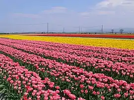
| • Flower | Tulip |
| • Bird | Crested kingfisher |
| Phone number | 0254-43-6111 |
| Address | 2-10 Shinwa, Tainai-shi, Niigata-ken 959-2693 |
| Website | Official website |
Geography
Tainai is located in northern Niigata Prefecture, bordered by Yamagata Prefecture to the east and the Sea of Japan to the west. The city area has an elongated shape from east to west along the Tainai River basin. There are number of dams in Tainai, including the Tainaigawa Dam and Tainai Dam.
Surrounding municipalities
Climate
Tainai has a Humid climate (Köppen Cfa) characterized by warm, wet summers and cold winters with heavy snowfall. The average annual temperature in Tainai is 12.8 °C (55°F). The average annual rainfall is 2014 mm (79.3 in) with September as the wettest month. The temperatures are highest on average in August, at around 26.1 °C (79°F), and lowest in January, at around 1.0 °C (33.8°F).[2]
| Climate data for Nakajō, Niigata (1981-2010) | |||||||||||||
|---|---|---|---|---|---|---|---|---|---|---|---|---|---|
| Month | Jan | Feb | Mar | Apr | May | Jun | Jul | Aug | Sep | Oct | Nov | Dec | Year |
| Average high °C (°F) | 4.8 (40.6) |
5.3 (41.5) |
9.3 (48.7) |
16.5 (61.7) |
21.5 (70.7) |
25.1 (77.2) |
28.6 (83.5) |
31.0 (87.8) |
26.5 (79.7) |
20.5 (68.9) |
14.1 (57.4) |
8.4 (47.1) |
17.6 (63.7) |
| Daily mean °C (°F) | 2.1 (35.8) |
2.1 (35.8) |
5.1 (41.2) |
11.3 (52.3) |
16.4 (61.5) |
20.5 (68.9) |
24.3 (75.7) |
26.2 (79.2) |
21.8 (71.2) |
15.8 (60.4) |
10.0 (50.0) |
5.1 (41.2) |
13.4 (56.1) |
| Average low °C (°F) | −0.6 (30.9) |
−0.8 (30.6) |
1.3 (34.3) |
6.3 (43.3) |
11.7 (53.1) |
16.5 (61.7) |
20.7 (69.3) |
22.3 (72.1) |
18.0 (64.4) |
11.7 (53.1) |
6.1 (43.0) |
2.1 (35.8) |
9.6 (49.3) |
| Average precipitation mm (inches) | 255.2 (10.05) |
166.1 (6.54) |
134.0 (5.28) |
114.9 (4.52) |
131.5 (5.18) |
148.7 (5.85) |
212.4 (8.36) |
164.0 (6.46) |
172.0 (6.77) |
199.4 (7.85) |
260.7 (10.26) |
273.6 (10.77) |
2,232.5 (87.89) |
| Mean monthly sunshine hours | 33.7 | 52.7 | 104.1 | 164.1 | 188.2 | 167.4 | 159.9 | 202.0 | 139.7 | 125.8 | 70.8 | 41.1 | 1,449.5 |
| Source: Japan Meteorological Agency | |||||||||||||
Demographics
Per Japanese census data,[3] the population of Tainai has declined steadily over the past 40 years.
| Year | Pop. | ±% |
|---|---|---|
| 1960 | 36,238 | — |
| 1970 | 35,651 | −1.6% |
| 1980 | 35,605 | −0.1% |
| 1990 | 35,517 | −0.2% |
| 2000 | 34,278 | −3.5% |
| 2010 | 31,424 | −8.3% |
History
The area of present-day Tainai was part of ancient Echigo Province. Following the Meiji restoration, the area was organized as part of Kitakanbara District, Niigata. The town of Nakajō, and the village of Kurokawa were established with the establishment of the modern municipalities system on April 1, 1889. The city of Tainai was established on September 1, 2005, from the merger of these municipalities.
Government
Tainai has a mayor-council form of government with a directly elected mayor and a unicameral city legislature of 14 members. Tainai contributes one member to the Niigata Prefectural Assembly. In terms of national politics, the city is part of Niigata 3rd district of the lower house of the Diet of Japan.
Economy
The economy of Tainai is primarily agricultural, mainly with rice cultivation, vegetables, flower cultivation, livestock farming, and fruit tree cultivation. Hydroelectric power generation also provides significant income to the local economy.
Education
Tainai has six public elementary schools and four public middle schools operated by the city government. The city has one public high school operated by the Niigata Prefectural Board of Education. There is also one private high school.
Transportation
Sister city relations
 - Carbondale, Illinois, USA
Local attractions
- Tossaka Castle ruins, a National Historic Site
- Jōnoyama Kofun, a National Historic Site
- Oppo-ji, a Buddhist temple whose 3-story pagoda is a National Important Cultural Property
References
External links
 Media related to Tainai, Niigata at Wikimedia Commons
- Official Website (in Japanese)
| Niigata |
| |||
|---|---|---|---|---|
| Special cities | ||||
| Cities | ||||
| Districts | ||||
