Nagaoka, Niigata
Nagaoka (長岡市, Nagaoka-shi) is a city located in Niigata Prefecture, Japan. It is the second largest city in the prefecture, after the capital city of Niigata. As of 1 December 2020, the city had an estimated population of 266,539 in 108,901 households [1] and a population density of 300 inhabitants per square kilometre (780/sq mi). The total area of the city was 891.06 square kilometres (344.04 sq mi).[2]
Nagaoka
長岡市 | |||||||||||||||||||
|---|---|---|---|---|---|---|---|---|---|---|---|---|---|---|---|---|---|---|---|
| |||||||||||||||||||
 Flag  Seal | |||||||||||||||||||
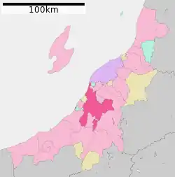 Location of Nagaoka in Niigata | |||||||||||||||||||
 Nagaoka | |||||||||||||||||||
| Coordinates: 37°26′46.3″N 138°51′4.5″E | |||||||||||||||||||
| Country | Japan | ||||||||||||||||||
| Region | Chūbu (Kōshin'etsu) (Hokuriku) | ||||||||||||||||||
| Prefecture | Niigata | ||||||||||||||||||
| Founded | 1616 | ||||||||||||||||||
| City established | April 1, 1906 | ||||||||||||||||||
| Government | |||||||||||||||||||
| • Mayor | Tatsunobu Isoda | ||||||||||||||||||
| Area | |||||||||||||||||||
| • Total | 891.06 km2 (344.04 sq mi) | ||||||||||||||||||
| Population (December 2020) | |||||||||||||||||||
| • Total | 266,539 | ||||||||||||||||||
| • Density | 300/km2 (770/sq mi) | ||||||||||||||||||
| Time zone | UTC+9 (Japan Standard Time) | ||||||||||||||||||
| Symbols | |||||||||||||||||||
| • Tree | Zelkova serrata | ||||||||||||||||||
| • Flower | Azalea | ||||||||||||||||||
| • Fish | Nishiki koi | ||||||||||||||||||
| Phone number | 0258-35-1122 | ||||||||||||||||||
| Address | 1-4-10 Otedori, Nagaoka-shi, Niigata-ken 940-8501 | ||||||||||||||||||
| Website | Official website | ||||||||||||||||||
Geography
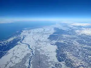
Nagaoka is in the center of Niigata prefecture and the surrounding Chūetsu region of Japan, between longitude 138°E and latitude 37°N. It is 80 minutes from Tokyo by way of the Joetsu Shinkansen or three hours on the Kan-Etsu Expressway and is considered a strategic traffic point in the region. Nagaoka was an inland city until January 1, 2006, when the city merged with four municipalities; two were touching the Sea of Japan. The Shinano River flows through the city from south to north and industrial development is on both banks of the river. The Higashiyama mountain range lies to the east.
Surrounding municipalities
From the north, following Nagaoka's border counterclockwise: Niigata Prefecture
- Tsubame
- Yahiko, Nishikanbara District
- Nishikan-ku, Niigata
- Izumozaki, Santō District
- Kashiwazaki
- Kariwa
- Tōkamachi
- Ojiya
- Uonuma
- Sanjō
- Mitsuke
Sado Island is connected by sea and air routes.
Climate
Nagaoka has a Humid climate (Köppen Cfa) characterized by warm, wet summers and cold winters with heavy snowfall. The average annual temperature in Nagaoka is 12.6 °C. The average annual rainfall is 2336 mm with September as the wettest month. The temperatures are highest on average in August, at around 26.0 °C, and lowest in January, at around 0.3 °C.[3]
| Climate data for Nagaoka, Niigata (1981-2010) | |||||||||||||
|---|---|---|---|---|---|---|---|---|---|---|---|---|---|
| Month | Jan | Feb | Mar | Apr | May | Jun | Jul | Aug | Sep | Oct | Nov | Dec | Year |
| Average high °C (°F) | 4.3 (39.7) |
4.7 (40.5) |
8.7 (47.7) |
16.4 (61.5) |
21.6 (70.9) |
25.3 (77.5) |
28.6 (83.5) |
30.8 (87.4) |
26.2 (79.2) |
20.1 (68.2) |
13.7 (56.7) |
7.7 (45.9) |
17.3 (63.2) |
| Daily mean °C (°F) | 1.3 (34.3) |
1.4 (34.5) |
4.3 (39.7) |
10.8 (51.4) |
16.3 (61.3) |
20.5 (68.9) |
24.2 (75.6) |
26.0 (78.8) |
21.5 (70.7) |
15.3 (59.5) |
9.3 (48.7) |
4.2 (39.6) |
12.9 (55.3) |
| Average low °C (°F) | −1.2 (29.8) |
−1.4 (29.5) |
0.7 (33.3) |
5.8 (42.4) |
11.6 (52.9) |
16.6 (61.9) |
20.7 (69.3) |
22.1 (71.8) |
17.9 (64.2) |
11.4 (52.5) |
5.6 (42.1) |
1.3 (34.3) |
9.3 (48.7) |
| Average precipitation mm (inches) | 299.7 (11.80) |
168.8 (6.65) |
144.4 (5.69) |
96.8 (3.81) |
109.0 (4.29) |
132.2 (5.20) |
225.5 (8.88) |
148.4 (5.84) |
173.8 (6.84) |
194.5 (7.66) |
291.7 (11.48) |
340.1 (13.39) |
2,324.9 (91.53) |
| Average snowfall cm (inches) | 236 (93) |
189 (74) |
80 (31) |
4 (1.6) |
0 (0) |
0 (0) |
0 (0) |
0 (0) |
0 (0) |
0 (0) |
2 (0.8) |
89 (35) |
600 (235.4) |
| Mean monthly sunshine hours | 47.3 | 65.8 | 109.0 | 166.2 | 184.7 | 144.7 | 143.7 | 192.4 | 131.3 | 129.7 | 89.2 | 57.7 | 1,461.7 |
| Source: Japan Meteorological Agency | |||||||||||||
Demographics
Per Japanese census data,[4] the population of Nagaoka peaked at around 1995 and has declined steadily since.
| Year | Pop. | ±% |
|---|---|---|
| 1960 | 284,026 | — |
| 1970 | 279,395 | −1.6% |
| 1980 | 289,234 | +3.5% |
| 1990 | 290,923 | +0.6% |
| 2000 | 292,887 | +0.7% |
| 2010 | 282,674 | −3.5% |
History
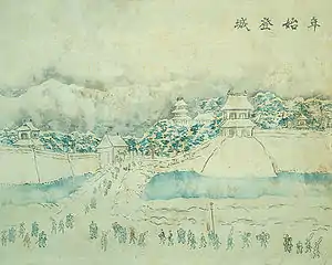
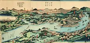
The area of present-day Nagaoka was part of ancient Echigo Province. Under the Tokugawa shogunate, a castle town was constructed by Hori Naoyori lord of Nagaoka Domain in 1616. However, as the initial castle was located in an area prone to flooding by the Shinano River, a new castle was built at the site of present-day Nagaoka Station in 1617. Nagaoka flourished as under the reign of the 13 generations of the Makino clan during the Edo period. In the Boshin War of 1868 during the Meiji Restoration, Nagaoka Domain was a member of the Ōuetsu Reppan Dōmei against the imperial forces, and the city was reduced to rubble during the Battle of Hokuetsu. A gift of one hundred sacks of rice from a neighboring province was sold to finance a new school during the reconstruction of Nagaoka, from which the anecdote of Kome Hyappyo was born.
With the Meiji period creation of the modern municipalities system on April 1, 1889, the towns of Nagaoka and Nagaoka-honmachi were established. The two towns were merged on November 1, 1901 with the towns of Senju, Kusouzu, Ara, and village of Ouchi to form the modern town of Nagaoka, which was then raised to city status on April 1, 1906.
Municipal timeline
- April 1, 1906: The city of Nagaoka is established.
- August 1, 1945: Nagaoka is reduced to rubble by 125 B-29 bombers in the Bombing of Nagaoka in World War II. 1,470 lives are lost.
- January 1963: A record-breaking heavy snowfall hits Nagaoka.
- November 15, 1982: Joetsu Shinkansen service arrives at Nagaoka Station.
- July 12–13, 2004: A heavy downpour causes extensive flooding in Nagaoka.
- October 23, 2004: The Chūetsu earthquake strikes, causing extensive damage in Nagaoka and surrounding areas.
- February 2005: Nagaoka experiences the heaviest snowfall in 19 years.
- April 1, 2005: The town of Oguni (from Kariwa District), the village of Yamakoshi (from Koshi District), the town of Nakanoshima (from Minamikanbara District), and the towns of Koshiji and Mishima (both from Santō District), were absorbed into Nagaoka. Prior to the merger, the size of Nagaoka was 262.45 km² and the population was 192,292.
- January 1, 2006: The city of Tochio, the towns of Teradomari and Yoita, and the village of Washima (all from Santō District) were absorbed into Nagaoka.
- April 1, 2007: Nagaoka is designated a special city with increase local autonomy
- March 31, 2010: The town of Kawaguchi (from Kitauonuma District) was absorbed into Nagaoka.[5]
Government
Nagaoka has a mayor-council form of government with a directly elected mayor and a unicameral city legislature of 34 members. The city contributes six members to the Niigata Prefectural Assembly. In terms of national politics, the city is part of Niigata 5th district of the lower house of the Diet of Japan.
Economy
Industry
The manufacturing industry prospered in Nagaoka following World War II, due in part to favorable location and good transportation infrastructure. Current industrial production includes precision instruments and machine tools.
- Nippon Seiki, a manufacturer of automotive instruments, is headquartered in Nagaoka.
- TDK-Lambda, a manufacturer of switched-mode power supplies, has a plant in Nagaoka.
- Schlumberger, an oilfield services company has a location in Nagaoka.
Education
Universities and colleges
- Nagaoka University of Technology
- National Institute of Technology, Nagaoka campus
- Nagaoka University
- Nagaoka Institute of Design
Primary and secondary education
The city of Nagaoka operates 61 public elementary schools and 27 public middle schools. There is also one public middle school operated by the national government. Nagaoka also has nine public high schools operated by the Niigata Prefectural Board of Education and three private high schools. The prefecture also operates three special education schools in the city.
Transportation

Railway
![]() East Japan Railway Company (JR East) - Joetsu Shinkansen
East Japan Railway Company (JR East) - Joetsu Shinkansen
![]() JR East - Joetsu Line
JR East - Joetsu Line
- Echigo-Kawaguchi - <Ojiya> - Echigo-Takiya - Miyauchi - Nagaoka
- Tsukayama - Echigo-Iwatsuka - Raikōji - Maekawa - Miyauchi - Nagaoka - Kita-Nagaoka - Oshikiri
- Myōhōji - Ojimaya - Kirihara - Teradomari
Bus
Local bus service in Nagaoka is managed by Echigo Kotsu. The bus terminal located at the east entrance of Nagaoka Station serves as the hub for the route network. Service extends to all parts of the city as well as many outlying suburban areas and villages. A bus service connecting Nagaoka Station to Niigata, Niigata Station runs at intervals of approximately 30 minutes. Additionally, long-distance bus services are available to all major cities in the prefecture as well as Tokyo.
Expressway
Nagaoka JCT is a strategic interchange which connects two expressways, Hokuriku Expressway and Kan-Etsu Expressway.
.png.webp) Hokuriku Expressway - Ōzumi PA - Nagaoka JCT - Nagaoka-kita Bus stop - Nagaoka-kita IC(ETC Only) - Nakanoshima-Mitsuke IC
Hokuriku Expressway - Ōzumi PA - Nagaoka JCT - Nagaoka-kita Bus stop - Nagaoka-kita IC(ETC Only) - Nakanoshima-Mitsuke IC.png.webp) Kan-etsu Expressway - Echigo-Kawaguchi IC/SA - Ojiya IC* - Nagaokaminami-Koshiji IC(ETC Only) - Nagaoka IC - Nagaoka JCT
Kan-etsu Expressway - Echigo-Kawaguchi IC/SA - Ojiya IC* - Nagaokaminami-Koshiji IC(ETC Only) - Nagaoka IC - Nagaoka JCT- Ojiya IC is in Ojiya city
Twin towns – sister cities
 Fort Worth, United States (1987)
- Honolulu, United States (2002)
 Romainmôtier-Envy, Switzerland (2006)
 Taiarapu-Ouest, French Polynesia (1991)
 Trier, Germany (2006)
Friendship city
- Bamberg, Germany (1995)
Local attractions
Places of interest
- Kome Hyappyo Monument
- Tsuginosuke Kawai Monument in Yukyuzan Park
- Haibu Nagaoka Stadium
- The Niigata Prefectural Museum of Modern Art
- Niigata Prefectural Museum of History
- Yukyuzan Park
- National Government Echigo Hillside Park
- Nagaoka Lyric Hall
- Nagaoka City Local Museum
National Historic Sites
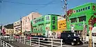
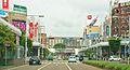 Ote-dori Street and Nagaoka Station
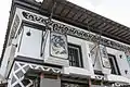 Quina Saffron Winery
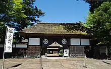 Hasegawa Family Residence
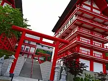 Houtokusan Inari Taisya Shrine
- Nagaoka City Local Museum
 Bull wrestling in Yamakoshi
 Nakayama tunnel
 Momijien
 Teradomari Aquarium
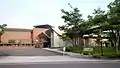 The Niigata Prefectural Museum of Modern Art
 Kawai Tsuginosuke Memorial Museum
 Yamamoto Isoroku Memorial Museum
 Ryōkan's grave (Ryusenji)
Festivals
| Wikimedia Commons has media related to Nagaoka Festival. |
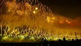
- Nagaoka Festival and Grand Fireworks Festival (August)
- Nagaoka Aki Matsuri (Autumn Festival) and Kome Hyappyo Festival (October)
Notable people from Nagaoka
- Ryō Hirohashi (voice actor)
- Tomoko Hoshino (actress)
- El Desperado (professional wrestler)
- Etsu Inagaki Sugimoto (writer)
- Inoue Enryō (Buddhist philosopher and founder of Toyo University)
- Yuki Kondo (mixed martial artist)
- Jūshirō Konoe (actor)
- Koharu Kusumi (Morning Musume)
- Haruo Minami (Enka singer)
- Nobuhiro Watsuki (manga artist)
- Isoroku Yamamoto (Commander of the Imperial Japanese Navy during the first four years of World War II)
References
- Nagaoka city official statistics(in Japanese)
- "Archived copy". Archived from the original on 2013-10-13. Retrieved 2013-11-24.CS1 maint: archived copy as title (link)
- Nagaoka climate data
- Itoigawa population statistics
- http://www.yomiuri.co.jp/dy/national/20100402TDY03T01.htm
- "Sister Cities and Friendship City". niea.or.jp. Nagaoka International Exchange Association. Retrieved 2020-04-07.
External links
| Wikimedia Commons has media related to Nagaoka, Niigata. |
- Official Website (in Japanese)
| Niigata |
| |||
|---|---|---|---|---|
| Special cities | ||||
| Cities | ||||
| Districts | ||||
| Authority control |
|---|
