Sanjō, Niigata
Sanjō (三条市, Sanjō-shi) is a city located in Niigata Prefecture, Japan. As of 1 July 2019, the city had an estimated population of 95,706 in 36,201 households,[1] and a population density of 222 persons per km². The total area of the city was 431.97 square kilometres (166.78 sq mi).
Sanjō
三条市 | |
|---|---|
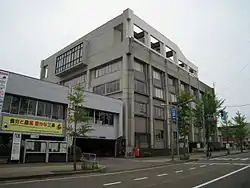 Sanjō City Hall | |
 Flag  Seal | |
 Location of Sanjō in Niigata | |
 Sanjō | |
| Coordinates: 37°38′12.4″N 138°57′42″E | |
| Country | Japan |
| Region | Chūbu (Kōshin'etsu) (Hokuriku) |
| Prefecture | Niigata |
| Area | |
| • Total | 431.97 km2 (166.78 sq mi) |
| Population (July 1, 2019) | |
| • Total | 95,706 |
| • Density | 220/km2 (570/sq mi) |
| Time zone | UTC+9 (Japan Standard Time) |
| Symbols | |
| • Tree | Japanese White Pine, Taxus cuspidata |
| • Flower | Liliaceae, Iris ensata, Sunflower |
| • Bird | Chicken (Shiba jidori) |
| Phone number | 0256-34-5511 |
| Address | 2-3-1 Asahi-chō, Sanjō-shi, Niigata-ken 955-8686 |
| Website | Official website |
Geography
Sanjō is located in an inland region of north-central Niigata Prefecture. It is about 2 hours from Tokyo via the Jōetsu Shinkansen or 4 hours on the Kan-Etsu Expressway and Hokuriku Expressway. The Shinano River flows through the west of it from south to north and the Ikarashi-gawa River flows through the centre of the urbanised area.
Surrounding municipalities
Climate
Sanjō has a Humid climate (Köppen Cfa) characterized by warm, wet summers and cold winters with heavy snowfall. The average annual temperature in Sanjō is 12.2 °C. The average annual rainfall is 2202 mm with September as the wettest month. The temperatures are highest on average in August, at around 25.6 °C, and lowest in January, at around 0.1 °C.[2]
Demographics
Per Japanese census data,[3] the population of Sanjō peaked at around 1985 and has declined steadily since.
| Census Year | Population |
|---|---|
| 1970 | 102,220 |
| 1980 | 109,429 |
| 1990 | 110,228 |
| 2000 | 107,662 |
| 2010 | 102,292 |
History
The area of present-day Sanjō was part of ancient Echigo Province. During the Edo period, the area was part of Sanjō Domain, a feudal domain under the Tokugawa shogunate from 1598 to 1651. Afterwards, it was divided between Nagaoka Domain, Murakami Domain and tenryō territory administered directly by the shogunate. After the start of the Meiji period, the area was organised as part of Minamikanbara District, Niigata. The town of Sanjō was created with the establishment of the modern municipalities system on April 1, 1889. It was raised to city status on January 1, 1934. Heavy rain causes extensive flooding in 1961 and in 2004. On May 1, 2005, the town of Sakae, and the village of Shitada (both from Minamikanbara District) were merged into Sanjō.
Government
Sanjō has a mayor-council form of government with a directly elected mayor and a unicameral city legislature of 22 members.[4] On November 8, 2020, attorney Ryo Takizawa was elected to become the next mayor of Sanjō.[5]
Economy
Sanjō is traditionally known for its iron crafts, notably knives and scissors.
- Snow Peak (camping manufacture) is headquartered in Sanjō
Education
Sanjō has 25 public elementary schools and nine public middle schools operated by the city government. There are four public high schools operated by the Niigata Prefectural Board of Education, and the prefecture also operates one special education school.
Transportation
Highway
Sister cities
.svg.png.webp) Vaughan, Ontario, Canada[6] (since October 18, 1993)
Vaughan, Ontario, Canada[6] (since October 18, 1993) Ezhou, China [6](since April 28, 1994)
Notable people from Sanjō
- Chihiro Kaneko (baseball player)[7]
- Tetsuji Morohashi (lexicographer)[8]
- Shohei Baba (professional wrestler)
- Kumi Mizuno (motion picture actress)
References
- Sanjō city official statistics(in Japanese)
- Sanjō climate data
- Sanjō population statistics
- Sanjō City Assembly homepage(in Japanese)
- "新潟県三条市長選挙、滝沢亮氏が初当選". 新潟県内のニュース|にいがた経済新聞 (in Japanese). Retrieved 2020-11-09.
- "International Exchange". List of Affiliation Partners within Prefectures. Council of Local Authorities for International Relations (CLAIR). Retrieved 8 December 2015.
- Chihiro Kaneko
- Tetsuji Morohashi Museum
External links
| Wikimedia Commons has media related to Sanjō, Niigata. |
- Official Website (in Japanese)
| Niigata |
| |||
|---|---|---|---|---|
| Special cities | ||||
| Cities | ||||
| Districts | ||||
| Authority control |
|---|