Taliabu Island Regency
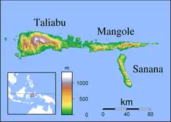
Taliabu Island Regency (Indonesian: Kabupaten Pulau Taliabu) is a regency in the North Maluku province of Indonesia. It was formerly part of the Sula Islands Regency, but in 2013 it was administratively separated to form a separate regency. It is located to the west of Mangole Island and Sanana Island, the two islands which remain part of the Sula Islands Regency.
Taliabu Island Regency
Kabupaten Pulau Taliabu | |
|---|---|
 Students seen playing volleyball at the local school | |
 Coat of arms | |
| Motto(s): Hemungsia Siadufu | |
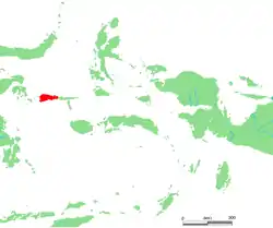 Location within Maluku Islands | |
| Coordinates: 1.8°S 124.8°E | |
| Country | |
| Province | |
| Capital | Bobong |
| Government | |
| • Regent | Aliong Mus |
| • Vice Regent | Ramli |
| Area | |
| • Total | 1,154.66 sq mi (2,990.55 km2) |
| Population (2010 Census) | |
| • Total | 47,309 |
| • Density | 41/sq mi (16/km2) |
| Time zone | UTC+9 (IEST) |
| Area code | (+62) 921 |
| Website | taliabukab |

Administration
In 2013 the seven districts (kecamatan) on Taliabu Island (and its offshore islets) were split off from the Sula Islands Regency to create a separate Taliabu Island Regency (Kabupaten Pulau Taliabu); they are tabulated below with their areas and their 2010 Census populations.
| Name | English name | Area in km2 | Population Census 2010 |
|---|---|---|---|
| Taliabu Barat Laut | Northwest Taliabu | 172.04 | 4,079 |
| Lede | 193.93 | 5,977 | |
| Taliabu Utara | North Taliabu | 792.43 | 10,880 |
| Taliabu Timur | East Taliabu | 377.37 | 3,542 |
| Taliabu Timur Selatan | Southwest Taliabu | 429.69 | 5,066 |
| Taliabu Selatan | South Taliabu | 469.28 | 8,738 |
| Taliabu Barat | West Taliabu | 4,079 | 9,027 |
| Taliabu Island Regency | 2,990.55 | 47,309 |
Climate
Bobong, the seat of the regency has a tropical rainforest climate (Af) with moderate rainfall in September and October and heavy rainfall in the remaining months.
| Climate data for Bobong | |||||||||||||
|---|---|---|---|---|---|---|---|---|---|---|---|---|---|
| Month | Jan | Feb | Mar | Apr | May | Jun | Jul | Aug | Sep | Oct | Nov | Dec | Year |
| Average high °C (°F) | 30.7 (87.3) |
30.6 (87.1) |
30.8 (87.4) |
31.0 (87.8) |
30.6 (87.1) |
30.3 (86.5) |
29.8 (85.6) |
30.2 (86.4) |
31.0 (87.8) |
31.4 (88.5) |
32.1 (89.8) |
31.1 (88.0) |
30.8 (87.4) |
| Daily mean °C (°F) | 26.9 (80.4) |
26.8 (80.2) |
27.0 (80.6) |
27.2 (81.0) |
27.1 (80.8) |
26.9 (80.4) |
26.4 (79.5) |
26.4 (79.5) |
26.8 (80.2) |
26.9 (80.4) |
27.9 (82.2) |
27.2 (81.0) |
27.0 (80.5) |
| Average low °C (°F) | 23.1 (73.6) |
23.1 (73.6) |
23.2 (73.8) |
23.4 (74.1) |
23.6 (74.5) |
23.6 (74.5) |
23.0 (73.4) |
22.6 (72.7) |
22.6 (72.7) |
22.4 (72.3) |
23.7 (74.7) |
23.3 (73.9) |
23.1 (73.7) |
| Average rainfall mm (inches) | 279 (11.0) |
245 (9.6) |
253 (10.0) |
226 (8.9) |
229 (9.0) |
262 (10.3) |
181 (7.1) |
125 (4.9) |
101 (4.0) |
103 (4.1) |
148 (5.8) |
215 (8.5) |
2,367 (93.2) |
| Source: Climate-Data.org[1] | |||||||||||||
References
- "Climate: Bobong". Climate-Data.org. Retrieved 23 November 2020.
External links
| Wikimedia Commons has media related to Taliabu Island Regency. |
Regencies and cities of North Maluku | ||
|---|---|---|
Capital: Sofifi | ||
| Regencies | ||
| Cities | ||