Tengger Desert
The Tengger Desert (Mongolian: Тэнгэр цөл, Chinese: 腾格里沙漠; pinyin: Ténggélǐ Shāmò; lit. 'Sky Desert') is an arid natural region that covers about 36,700 km2 and is mostly in the Inner Mongolia Autonomous Region in China.
Tengger Desert
Тэнгэр цөл / 腾格里沙漠 | |
|---|---|
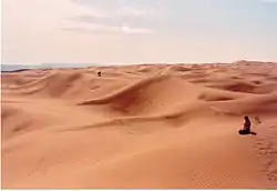 Landscape of the southern fringe of the Tengger Desert | |
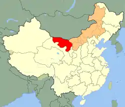 Map of China with Inner Mongolia highlighted in orange and Alxa League, where the desert is located, highlighted in red. | |
| Country | China |
| Area | |
| • Total | 36,700 km2 (14,200 sq mi) |
| Elevation | 1,400 m (4,600 ft) |
The desert is expanding in size.[1]
Environmental issues
The expansion of the Tengger and its neighbour, the Badain Jaran Desert, has been apparent since the 1950s, when large volumes of water were diverted from rivers to feed agricultural expansion and huge tracts of forest were removed. Since 1958, local governments have mobilised residents for afforestation campaigns to prevent the desert's spread. By 2004, the desert's expansion was estimated as 10 metres per year in some areas.[2] In 2007, a non-profit organisation founded by residents of Minqin County created square ditches lined with hay and grass that they later planted with saxaul to stabilise the sand dunes.[2] In 2010, the central and regional governments announced a five-year reforestation plan to create a 202-km green belt between the Tengger and Badain Jaran deserts. The project was estimated to receive 280 million yuan in funding and involve the relocation of 1,000 residents.[3]
Features
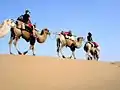 Camel ride in the Tengger Desert, August 19, 2005
.jpg.webp) Shapotou District, Tengger Desert
Shapotou District, Tengger Desert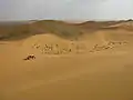 A view of the Tengger Desert
.jpg.webp) A view of the Tengger Desert
A view of the Tengger Desert
See also
References
- Haner, Josh, et al. (24 October 2016). Living in China's Expanding Deserts, The New York Times
- Yuan Ye (17 December 2019). "Island in the Sand". Sixth Tone. Retrieved 29 January 2021.
- "China plants green belt to stop deserts merging". Xinhua. 26 August 2010. Retrieved 29 January 2021.
External links
Inner Mongolia topics | |
|---|---|
| General | |
| Geography | |
| Education | |
| Culture | |
| Cuisine | |
| Visitor attractions | |
| |