Thma Bang District
Thma Bang District is one of six districts (srok) and a municipality of Koh Kong Province in south-west Cambodia. It is about 72 kilometres (45 mi) from central Koh Kong. Thma Bang district is bordered on the east by Sre Ambel District and Aoral District of Kompong Speu Province, on the west by Koh Kong District and Mondol Sima District, on the north by Velveng District and Krovanh District of Pursat Province and on the south by Botumsakor District. Thma Bang district has 6 communes comprising to 17 villages and occupies 3,465 square kilometres (1,338 sq mi). About 98% of the population are farmers who depend on agriculture and forest resources hunting for living.
| Thma Bang[2] | ||
| Khum (Commune) | Phum (Villages) | |
|---|---|---|
| Ta Tey Leu | Spean Kdar, Kandal, Trapeang Khnar | |
| Pralay | Chamnar, Pralay, Samraong, Toap Khley, Ta Ngil | |
| Chumnoab | Chumnoab, Chrak Ruessei | |
| Ruessei Chrum | Trapeang Chheu Trav, Kokir Chrum | |
| Chi-Phat | Chi Phat, Tuek L'ao, Chom Sla', Kom Lot | |
| Thmor Donpove | Kaoh, Preaek Svay | |
Thma Bang
ស្រុកថ្មបាំង | |
|---|---|
District (srok) | |
 Thma Bang Location in Cambodia | |
| Coordinates: 11°49′N 103°25′E | |
| Country | |
| Province | Koh Kong |
| Communes | 6 |
| Villages | 18 |
| Population (1998)[1] | |
| • Total | 2,880 |
| Time zone | +7 |
| Geocode | 0907 |
Notes
- General Population Census of Cambodia, 1998: Village Gazetteer. National Institute of Statistics. February 2000.
- Cambodia e-gov "Koh Kong" Archived 2008-12-24 at the Wayback Machine Accessed June 8, 2008
Capital: Khemarak Phoumin | ||
| Districts | 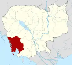 | |
| Places | ||
| Autonomous municipality |
| ||
|---|---|---|---|
| Provinces | |||
This article is issued from Wikipedia. The text is licensed under Creative Commons - Attribution - Sharealike. Additional terms may apply for the media files.