Tongguan County
Tongguan County (alternately romanized as Tungkwan[lower-alpha 1]) is a county in the east of Shaanxi province, China, administered as part of the prefecture-level city of Weinan. It is named after the Tong Pass, located south of the confluence of the Wei and Yellow Rivers. It is the southeastern corner of the Ordos Loop, the point at which the Qin Mountains turn the Yellow River sharply eastward, forcing it into the North China Plain, and borders the provinces of Shanxi to the north and Henan to the east.
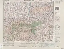
Map including Tongguan (labeled as 潼關 T'UNG-KUAN (TUNGKWAN) (walled)) (AMS, 1955)
Tongguan County
潼关县 Tungkwan, T'ung-kuan | |
|---|---|
 Tongguan | |
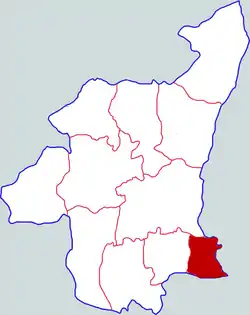 Tongguan in Weinan | |
.png.webp) Weinan in Shaanxi | |
| Country | People's Republic of China |
| Province | Shaanxi |
| Prefecture-level city | Weinan |
| Area | |
| • Total | 526 km2 (203 sq mi) |
| Population (2018) | |
| • Total | 154,200 |
| • Density | 290/km2 (760/sq mi) |
| Time zone | UTC+8 (China Standard) |
| Postal Code | 714300 |
| Website | http://www.tongguan.gov.cn/ |
| Tongguan | |||||||||
|---|---|---|---|---|---|---|---|---|---|
| Traditional Chinese | 潼關 | ||||||||
| Simplified Chinese | 潼关 | ||||||||
| Postal | Tungkwan | ||||||||
| Literal meaning | High Pass | ||||||||
| |||||||||
Administrative divisions
Tongguan County is divided to 5 towns and 1 townships.[2]
- Towns
|
|
- Townships
- Anle (安乐乡)
Notes
- Tongguan has also been romanized as Tung-kwan.[1]
References
- Encyclopædia Britannica, 9th ed. (1878), Vol. V, "China".
- "潼关县-行政区划网(区划地名网) www.xzqh.org". www.xzqh.org. Retrieved 2016-11-12.
| Wikimedia Commons has media related to Tongguan. |
This article is issued from Wikipedia. The text is licensed under Creative Commons - Attribution - Sharealike. Additional terms may apply for the media files.