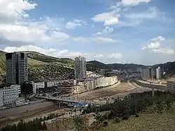
Wuqi County
Wuqi County (simplified Chinese: 吴起县; traditional Chinese: 吳起縣; pinyin: Wúqǐ Xiàn) is a county under the jurisdiction of Yan'an City, in the northwest of Shaanxi Province, China, bordering Gansu province to the southwest. The county spans an area of 3,788.5 square kilometers, and has a population of 145,600 as of 2012.[1]
Wuqi
吴起县 | |
|---|---|
 | |
| Coordinates (Wuqi County government): 36°55′39″N 108°10′35″E | |
| Country | People's Republic of China |
| Province | Shaanxi |
| Prefecture-level city | Yan'an |
| Area | |
| • Total | 3,788.5 km2 (1,462.7 sq mi) |
| Population (2012) | |
| • Total | 145,600 |
| • Density | 38/km2 (100/sq mi) |
| Time zone | UTC+8 (China standard time) |
| Licence plates | 陕J |
Administrative divisions
The county is divided into 1 subdistrict and 8 towns.[1][2]
| Zoning Code[2] | English Name | Hanzi | Pinyin |
|---|---|---|---|
| 610626001000 | Wuqi Subdistrict | 吴起街道 | Wúqǐ Jiēdào |
| 610626101000 | Tiebiancheng | 铁边城镇 | Tiěbiānchéng Zhèn |
| 610626102000 | Zhouwan | 周湾镇 | Zhōuwān Zhèn |
| 610626103000 | Baibao | 白豹镇 | Báibào Zhèn |
| 610626104000 | Zhangguanmiao | 长官庙镇 | Zhǎngguānmiào Zhèn |
| 610626105000 | Changcheng | 长城镇 | Chángchéng Zhèn |
| 610626106000 | Wugucheng | 五谷城镇 | Wǔgǔchéng Zhèn |
| 610626107000 | Wucangbao | 吴仓堡镇 | Wúcāngbǎo Zhèn |
| 610626108000 | Miaogou | 庙沟镇 | Miàogōu Zhèn |
Geography
Wuqi is adjacent to Dingbian County in the northwest, Zhidan County in the southeast, Jingbian County in the northeast, and Huachi County in Gansu Province in the southwest.[1][3] The county's two main rivers are the Wuding River and the Beiluo River.[3] The region is largely hilly, with the terrain's altitude varying from 1,233 to 1,809 meters in height.[3]
History
On October 19, 1935, forces belonging to the People's Republic of China captured the area.[3] An account of Wuqi (Wu Ch'i, in Wade-Giles Romanization) in 1936 can be found in Edgar Snow's "Red Star over China". At the time, it was the main industrial center of the communist-controlled Shaanxi/Gansu/Ningxia borderlands area, This is where the Red Army's arsenal. cloth, uniform, shoe and stockings factories were at the time. As Edgar Snow noted, the arsenal's products were mostly used to arm the Red guerilla fighters, while the regular Red Army units mostly used weapons captured from the enemy (Kuomintang and warlord) troops.[4] The area was a part of the Shaan-Gan-Ning Border Region.[3]
Economy
As of 2016, Wuqi County had a GDP of 10.8 billion Renminbi.[3] The county's urban residents had a per capita disposable income of 32,883 Yuan, and its agrarian residents had one of 11,538 Yuan.[3]
Transportation
The county is home the Yan'an-Dingbian Road.[1]
References
- 吴起县概况地图_行政区划网(区划地名网) www.xzqh.org (in Chinese). XZQH.org. Retrieved 2020-05-02.
- 2018年统计用区划代码 (in Chinese). National Bureau of Statistics of the People's Republic of China. Retrieved 2020-05-02.
- 吴起概况-吴起县政府. Wuqi County People's Government. 2017-08-13. Archived from the original on 2017-08-13. Retrieved 2020-05-02.
- Edgar Snow, "The Red Star over China". Multiple editions. Part Seven: "En Route to the Front".