Totsukawa
Totsukawa (十津川村, Totsukawa-mura) is a village located in Yoshino District, Nara Prefecture, Japan. It is the largest village in Japan in terms of area.
Totsukawa
十津川村 | |||||||||||||
|---|---|---|---|---|---|---|---|---|---|---|---|---|---|
Village | |||||||||||||
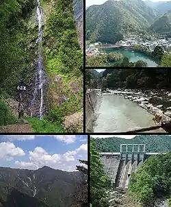 Clockwise from top left: Jyuni Waterfall, Totsukawa Spa area, Kamiyu Spa area, Kazeya Dam, Mount Shaka | |||||||||||||
 Flag  Seal | |||||||||||||
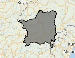
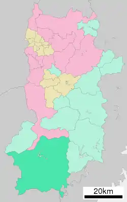
Location of Totsukawa in Nara Prefecture | |||||||||||||
 | |||||||||||||
| Country | Japan | ||||||||||||
| Region | Kansai | ||||||||||||
| Prefecture | Nara Prefecture | ||||||||||||
| District | Yoshino | ||||||||||||
| First official recorded | 37 BC | ||||||||||||
| Village settled | June 18, 1890 | ||||||||||||
| Government | |||||||||||||
| • Mayor | Yoshiki Saratani | ||||||||||||
| Area | |||||||||||||
| • Total | 672.35 km2 (259.60 sq mi) | ||||||||||||
| Population (January 1, 2017) | |||||||||||||
| • Total | 3,488 | ||||||||||||
| • Density | 5.2/km2 (13/sq mi) | ||||||||||||
| Time zone | UTC+09:00 (JST) | ||||||||||||
| City hall address | 225-1 Ōaza Ohara, Totsukawa-mura, Yoshino-gun, Nara-ken 637-1333 | ||||||||||||
| Website | www | ||||||||||||
| |||||||||||||
As of January 2017, the village has an estimated population of 3,488[1] and a density of 5.2 persons per km2. The total area is 672.35 km2.
History
In 1889, a major flood happened in Totsukawa, causing widespread destruction. In result, many citizens moved to Hokkaido and developed a new village there. It was named “Shintotsukawa”, meaning “New Totsukawa" .
Climate
Totsukawa has a humid subtropical climate (Köppen climate classification Cfa), which is hot and humid in the summer (above 30 °C (86 °F)) and is somewhat cold in the winter with temperatures dropping to around freezing (0 °C (32 °F))
| Climate data for Kazeya (Kazeya Totsukawa, elevation 301 m (988 ft)) | |||||||||||||
|---|---|---|---|---|---|---|---|---|---|---|---|---|---|
| Month | Jan | Feb | Mar | Apr | May | Jun | Jul | Aug | Sep | Oct | Nov | Dec | Year |
| Record high °C (°F) | 16.3 (61.3) |
20.9 (69.6) |
25.5 (77.9) |
31.6 (88.9) |
34.5 (94.1) |
35.8 (96.4) |
38.0 (100.4) |
39.4 (102.9) |
36.0 (96.8) |
30.4 (86.7) |
23.6 (74.5) |
21.7 (71.1) |
39.4 (102.9) |
| Average high °C (°F) | 7.7 (45.9) |
8.9 (48.0) |
12.7 (54.9) |
18.8 (65.8) |
23.1 (73.6) |
25.9 (78.6) |
29.7 (85.5) |
30.8 (87.4) |
27.0 (80.6) |
21.0 (69.8) |
15.5 (59.9) |
10.2 (50.4) |
19.3 (66.7) |
| Daily mean °C (°F) | 3.2 (37.8) |
3.8 (38.8) |
7.0 (44.6) |
12.3 (54.1) |
16.7 (62.1) |
20.3 (68.5) |
24.0 (75.2) |
24.6 (76.3) |
21.4 (70.5) |
15.6 (60.1) |
10.2 (50.4) |
5.3 (41.5) |
13.7 (56.7) |
| Average low °C (°F) | −0.4 (31.3) |
−0.2 (31.6) |
2.2 (36.0) |
6.8 (44.2) |
11.5 (52.7) |
16.1 (61.0) |
20.2 (68.4) |
20.7 (69.3) |
17.7 (63.9) |
11.6 (52.9) |
6.0 (42.8) |
1.3 (34.3) |
9.4 (48.9) |
| Record low °C (°F) | −6 (21) |
−7.2 (19.0) |
−4.4 (24.1) |
−1.9 (28.6) |
2.1 (35.8) |
8.2 (46.8) |
13.0 (55.4) |
13.8 (56.8) |
8.9 (48.0) |
1.6 (34.9) |
−1.6 (29.1) |
−4.8 (23.4) |
−7.2 (19.0) |
| Average precipitation mm (inches) | 78.6 (3.09) |
98.5 (3.88) |
166.2 (6.54) |
160.4 (6.31) |
219.1 (8.63) |
321.7 (12.67) |
356.8 (14.05) |
270.5 (10.65) |
282.7 (11.13) |
167.9 (6.61) |
111.1 (4.37) |
69.4 (2.73) |
2,314 (91.10) |
| Mean monthly sunshine hours | 96.2 | 98.0 | 122.8 | 145.1 | 142.0 | 108.1 | 130.6 | 147.9 | 112.9 | 114.6 | 109.6 | 105.6 | 1,429.5 |
| Source 1: Japan Meteorological Agency (1981 - 2010)[2] | |||||||||||||
| Source 2: Japan Meteorological Agency (1976 - )[3] | |||||||||||||
Landmarks
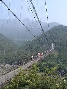
- Tanize Suspension Bridge (谷瀬の吊り橋): a suspension bridge known for the Yuredaiko, an annual drum festival on the bridge.
- Sasanotaki (笹の滝): a waterfall listed on the 100 best waterfalls in Japan.
- Tamaki Shrine (玉置神社): a Shinto shrine located at the top of Mt. Tamaki built by the Emperor Sujin in 37 BC and is surrounded by many big cedar trees. Tamaki Shrine is registered with the UNESCO World Heritage Centre as part of the "Sacred Sites and Pilgrimage Routes in the Kii Mountain Range."
- Tosenji Onsen (湯泉地温泉): a hot spring listed on the 100 best hot springs in Japan.
Transportation
Totsukawa is served by National Routes 168 and 425. The nearest major train station is Hashimoto Station in Wakayama Prefecture.
Sister cities
References
- "Official website of Totsukawa Village" (in Japanese). Japan: Totsukawa Village. Retrieved 24 April 2017.
- 風屋 年・月ごとの平年値 (in Japanese). Japan Meteorological Agency. Retrieved 4 April 2018.
- 風屋 観測史上1~10位の値 (in Japanese). Japan Meteorological Agency. Retrieved 4 April 2018.
External links
 Media related to Totsukawa, Nara at Wikimedia Commons
 Geographic data related to Totsukawa at OpenStreetMap
- Totsukawa Village web page (in Japanese)
| Core city | ||
|---|---|---|
| Cities | ||
| Districts | ||
| Authority control |
|---|