Transport in Algeria
As the tenth-largest country in the world, and the largest in Africa and in the Mediterranean region, Algeria has a vast transportation system that includes a large transportation infrastructure.
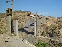
Railways
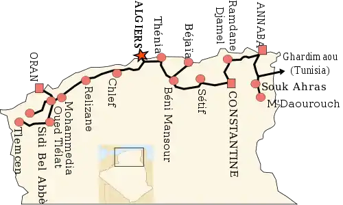
There are a total of 3,973 km (2,469 mi) of railways: 2,888 km (1,795 mi) is 1,435 mm (4 ft 8 1⁄2 in) standard gauge, with 283 km (176 mi) of that being electrified and 215 km (134 mi) of that being double tracked. There are also a total of 1,085 km (674 mi) of 1,055 mm (3 ft 5 1⁄2 in) gauge track.
SNTF operates the railways, whilst a new, separate organisation, Anesrif, has been created to manage infrastructure investment.
The High Plateau line is a major new project to build an east-west line across the country, parallel to the Rocade Nord.[1]
2009
2006
- A new 204-kilometre (127 mi) railway currently under construction from Tébessa to Aïn M'Lila. The 8 km (5.0 mi) Algiers bypass line between Djasr Kasentina and Oued Smar is also being upgraded.
- 18 May 2006 SNTF is to spend $US5 billion (about R30bn) in the next five years on improvements.[3] It has awarded a 39-month-duration contract worth €248.3 million to a joint Algerian and Spanish consortium that will double the Annaba-Ramdane Djamal portion of the 626 km (389 mi) Algiers-Annaba line and upgrade the track for 160 km/h (37 mph) operation.
- SNTF is to electrify 420 km (260 mi) of the route west of Annaba at 25 kV AC, including the branches from Ramdane Djamel to Skikda (19 km or 12 mi) and Beni Mansour to Bejaia (88 km or 55 mi), as well as the line from Khemis Miliana to Oran (303 km or 188 mi).
- 18 May 2006 - By early 2009, it is hoped to open the first 16.3 km (10.1 mi) section of the new light rail line in Algeria's capital city, linking Carl du Ruisseau to Bordj El Kiffan.[4]
- Under construction: there are 3 projects to build tramway networks in 3 major cities: Alger, Oran and Constantine (9 km or 5.6 mi, planned opening 2010).[5]
- CAF is to supply 17 non-tilting diesel multiple-units based on the RENFE Series 598 tilting trains.[3]
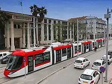
Tramways
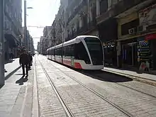
Currently the cities of Algiers, Oran, Constantine, Setif, Sidi bel Abbes and Ouargla have a tram line in operation. Tram projects have been launched in the east in Mostaganem since 2015.[6] The government, wanting to diversify the country's future in rail transport, has assigned the Algiers Subway Company to the projects.
- Algiers tramway (2011)
- Oran Tramway (2013)18.7 kilometres (11.6 mi) of route and 32 stops.[7]
- Constantine tramway (2013) 8.9 kilometres
- Ouargala tramway (2018)[8] 9.7 kilometres (6.0 mi)
- Sidi Bel Abbès tramway (June 2017) 13.74 kilometres (8.54 mi) of route and 22 stops.[9]
- Ouargala tramway (March 2018) 9.7 kilometres (6.0 mi) of route and 16 stops.[8]
- Setif tramway (May 2018) 22.4 kilometres (13.9 mi) of route and 26 stops.[10]
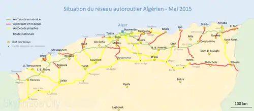
Highways
There are over 96,000 kilometers of paved roads including 1394 kilometers of expressways and 29,000 kilometers of unpaved roads for a total road system of about 127,000 kilometers.[11]
Regional highways
Algeria has two routes in the Trans-African Highway network, including the Trans-Sahara Highway, soon to be complete as a paved road running from north to south through the country. The country has also embarked (as of 2006) in the construction of a new East-West highway.[12]
Motorways
Motorway network in Algeria is expanding increasingly, along with other kinds of infrastructure, though this is only true for the Northern region of the country, where most of its population lives. Due to extensive investment the infrastructure is pretty well developed.
- East-West Highway. This is the most important road infrastructure in the country, because it expands from Ain El Assel, on the border with Tunisia to Zouj Beghal (Maghnia), on the border with Morocco. Along its way, it also links the cities of Constantine, Sétif, Algiers, Blida, Chlef, Sidi Bel Abbes and Tlemcen. It has a length of 1155 km.
- Highway of the Hauts Plateaux is a highway of 1020 km under construction in Algeria in parallel to the East–West Highway. It goes through the wilayas of Tlemcen on the border with Morocco, Saida, Tiaret, Medea, M'sila, Batna, Oum El Bouaghi, Khenchela and Tebessa on the border with Tunisia.[13]
- National Highway 4. Extends from Oran to Boufarik, total length: 384 km. It is a motorway on its extent from Oran to Zaghloul (Zahana), length: 35 km.
- National Highway 5. It is a motorway on its extent from Dar El Beïda to Ammal. Length: 82 km.
- National Highway 11. It is a motorway running from Alger to Cherchell. Length: 65 km.
- National Highway 12. It is a motorway running from Si Mustapha to Tizi Ouzou. Length: 57 km.
Pipelines
There are 456 kilometers of crude oil pipeline, 298 kilometers of refined petroleum pipeline, and 2,948 kilometers of natural gas pipeline. There are also 4 gas exportation pipelines, two existing ones to Spain (Maghreb-Europe Gas Pipeline) and Italy (Trans-Mediterranean Pipeline) and 2 under construction, Medgaz between Oran and Almería, Spain and GALSI between Annaba and Sardinia, Italy. Both pipelines will be extended to France and Germany.
Ports and harbors
Merchant marine
Total: 110 (2017, CIA World Factbook) by type: bulk carrier 3, general cargo 13, oil tanker 9, other 85 (2017)
Airports
An extensive air service used an estimated 137 airports and airstrips in 2004. As of 2005, a total of 52 had paved runways, and there was one heliport. The main international airport, Houari Boumedienne Airport, is about 20 km (12 mi) from Algiers. Constantine, Annaba, Tlemcen, and Oran have smaller modern airports that can accommodate jet aircraft. Air Algérie, the national airline, provides international service. In 2003, a total of about 3.293 million passengers were carried on domestic and international flights.
See also
References
- "Railway Gazette: Planning a railway to the High Plateau". Retrieved 2011-03-24.
- Inscription sur elmoudjahid
- Murray Hughes. "Desert riches fuel network revival". Railway Gazette International. Archived from the original on 2007-09-27. Retrieved 2007-09-03.
- "Railways Africa". RailwaysAfrica.
- "Metros". Railway Gazette International. 2006-07-01. Archived from the original on 2007-10-23. Retrieved 2007-09-03.
- ACCEUIL :: Entreprise Métro d'Alger
- "Oran tramway opens for business, with more Algerian LRT to come" (June 2013). Tramways & Urban Transit magazine, p. 212. LRTA Publishing (UK).
- Alioua, Houria (20 March 2018). "Le tramway de Ouargla mis en service" [Ouargla tramway put into service]. El Watan (in French). SPA El Watan Presse. Retrieved 2018-03-21.
- (in French) "Tramway de Sidi Bel Abbès : Les tests finaux prévus aujourd'hui". El Watan. 7 June 2017. Retrieved 27 June 2017.
- "First tram line inaugurated in the city of Sétif, Algeria". www.globalrailnews.com. Rail Media Company. 9 May 2018. Retrieved 2018-05-11.
- "Consistance du partinoine routier". Ministère des travaux publics.
- China and Japan consortium to construct Algeria's East-West Highway Magharebia 2006-04-19
- La Rocade Autoroutière Des Hauts Plateaux Archived 2016-08-20 at the Wayback Machine
![]() This article incorporates public domain material from the CIA World Factbook website https://www.cia.gov/the-world-factbook/.
This article incorporates public domain material from the CIA World Factbook website https://www.cia.gov/the-world-factbook/.
Currency: Algerian dinar | |
| Trade |
|
| Industries |
|