List of airports in Algeria

This is a list of airports in Algeria, grouped by type and sorted by location.

Map of Algeria

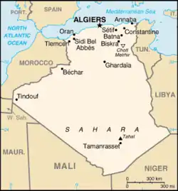
Algeria, officially known as the People's Democratic Republic of Algeria, is a country located in North Africa. It is the largest country on the Mediterranean Sea, and the African continent, as well as the tenth-largest country in the world in terms of land area. It is bordered by Tunisia in the northeast, Libya in the east, Niger in the southeast, Mali and Mauritania in the southwest, a few kilometers of the Moroccan-controlled Western Sahara in the southwest, Morocco in the west and northwest, and the Mediterranean Sea in the north. Algeria is divided into 48 provinces (wilayas), 553 districts (daïras) and 1,541 communes or municipalities.

Airports

Airport names shown in bold indicate the airport has scheduled service on commercial airlines.

City served Province ICAO IATA Airport name Coordinates AIP/Chart
International airports
Adrar Adrar DAUA AZR Touat-Cheikh Sidi Mohamed Belkebir Airport 27°50′21″N 00°11′07″W AIP Chart
Algiers Algiers DAAG ALG Houari Boumediene Airport 36°41′40″N 03°13′01″E AIP Chart
Annaba Annaba DABB AAE Rabah Bitat Airport 36°49′20″N 07°48′34″E AIP Chart
Batna Batna DABT BLJ Mostépha Ben Boulaid Airport 35°45′33″N 06°19′12″E AIP Chart
Béjaïa Béjaïa DAAE BJA Soummam – Abane Ramdane Airport 36°42′43″N 05°04′10″E AIP Chart
Biskra Biskra DAUB BSK Mohamed Khider Airport 34°47′35″N 05°44′17″E AIP Chart
Chlef Chlef DAOI CFK Chlef International Airport (Aboubakr Belkaid Airport) 36°12′45″N 01°19′54″E AIP Chart
Constantine Constantine DABC CZL Mohamed Boudiaf International Airport 36°17′07″N 06°37′09″E AIP Chart
El Oued El Oued DAUO ELU Guemar Airport 33°30′47″N 06°46′57″E AIP Chart
Ghardaïa Ghardaïa DAUG GHA Noumérat – Moufdi Zakaria Airport 32°22′54″N 03°47′58″E AIP Chart
Hassi Messaoud Ouargla DAUH HME Oued Irara–Krim Belkacem Airport 31°40′26″N 06°08′26″E AIP Chart
In Amenas Illizi DAUZ IAM In Amenas Airport (Zarzaitine Airport) 28°03′05″N 09°38′34″E AIP Chart
Jijel Jijel DAAV GJL Jijel Ferhat Abbas Airport 36°47′40″N 05°52′25″E AIP Chart
Oran Oran DAOO ORN Oran Ahmed Ben Bella Airport 35°37′38″N 00°36′41″W AIP Chart
Sétif Sétif DAAS QSF Ain Arnat Airport (8 Mai 45 Airport) 36°10′41″N 05°19′28″E AIP Chart
Tamanrasset Tamanrasset DAAT TMR Aguenar – Hadj Bey Akhamok Airport 22°48′40″N 05°27′03″E AIP Chart
Tébessa Tébessa DABS TEE Cheikh Larbi Tébessi Airport 35°25′57″N 08°07′32″E AIP Chart
Tlemcen Tlemcen DAON TLM Zenata – Messali El Hadj Airport 35°00′55″N 01°27′03″W AIP Chart
National airports
Béchar Béchar DAOR CBH Boudghene Ben Ali Lotfi Airport 31°39′17″N 02°15′40″W AIP Chart
Bordj Badji Mokhtar Adrar DATM BMW Bordj Mokhtar Airport 21°22′30″N 00°55′26″E AIP Chart
Bou Saâda M'Sila DAAD BUJ Bou Saada Airport 35°19′53″N 04°12′16″E AIP Chart
Djanet Illizi DAAJ DJG Tiska Djanet Airport 24°17′35″N 09°27′07″E AIP Chart
El Bayadh El Bayadh DAOY EBH El Bayadh Airport 33°43′15″N 01°05′29″E AIP Chart
El Goléa Ghardaïa DAUE ELG El Golea Airport 30°34′08″N 02°51′53″E AIP Chart
Illizi Illizi DAAP VVZ Takhamalt Airport 26°43′25″N 08°37′04″E AIP Chart
In Guezzam Tamanrasset DATG INF In Guezzam Airport 19°34′08″N 05°44′56″E AIP Chart
In Salah Tamanrasset DAUI INZ In Salah Airport 27°15′13″N 02°30′39″E AIP Chart
Mascara / Ghriss Mascara DAOV MUW Ghriss Airport 35°13′01″N 00°08′54″E AIP Chart
Ouargla Ouargla DAUU OGX Ain Beida Airport (Ain el Beida Airport) 31°55′02″N 05°24′46″E AIP Chart
Tiaret Tiaret DAOB TID Abdelhafid Boussouf Bou Chekif Airport 35°20′29″N 01°28′01″E AIP Chart
Timimoun Adrar DAUT TMX Timimoun Airport 29°14′28″N 00°17′01″E AIP Chart
Tindouf Tindouf DAOF TIN Tindouf Airport 27°42′01″N 08°10′02″W AIP Chart
Touggourt Ouargla DAUK TGR Sidi Mahdi Airport 33°04′03″N 06°05′27″E AIP Chart
Military airports
Aïn Beïda Oum El Bouaghi DABO Oum el Bouaghi Airport 35°52′39″N 07°15′26″E
Aïn Oussera Djelfa DAAQ Aïn Oussera Airport 35°31′32″N 02°52′43″E
Boufarik Blida DAAK Boufarik Airport 36°32′45″N 02°52′34″E
Bousfer Oran DAOE Bousfer Air Base 35°44′07″N 00°48′19″W
Mécheria Naâma DAAY MZW Mécheria Airport 33°32′08″N 00°14′32″W
Oran Oran DAOL TAF Oran Tafraoui Airport (Tafaraoui Airport) 35°32′33″N 00°31′56″W
Teleghma Mila DAAM Telerghma Airport 36°06′31″N 06°21′51″E
Other airports
Âouinet Bel Egrâ Tindouf Gara Djebilet Airport 26°53′01″N 07°09′53″W
Béchar Béchar DAOC Béchar Ouakda Airport 31°38′35″N 02°11′04″W
Béni Abbès Béchar Béni Abbès Airport 30°07′32″N 02°8′14″W
Blida Blida DAAB Blida Airport 36°30′13″N 02°48′51″E
Bordj Omar Driss Illizi DAAW Bordj Omar Driss Airport 28°07′55″N 06°49′59″E
Djelfa Djelfa DAFI Tsletsi Airport 34°39′56″N 03°21′03″E
Guelma Guelma Guelma Belkheir Airport - Closed 36°27′12″N 07°28′07″E
Hassi R'Mel Laghouat DAFH HRM Hassi R'Mel Airport (Tilrempt Airport) 32°55′49″N 03°18′41″E
Laghouat Laghouat DAUL LOO L'Mekrareg Airport 33°45′50″N 02°55′38″E
M'Sila M'Sila M'Sila Airport - Closed 35°42′35″N 04°27′30″E
Mostaganem Mostaganem MQV Mostaganem Airport 35°54′32″N 00°08′56″E
Reggane Adrar DAAN Reggane Airport 26°42′36″N 00°17′08″E
Relizane Relizane DAAZ Relizane Airport 35°45′08″N 00°37′35″E
Saïda Saïda Saïda Airport 34°53′50″N 00°09′06″E
Sidi Bel Abbès Sidi Bel Abbès DAOS BFW Sidi Bel Abbès Airport 35°10′19″N 00°35′35″W
Skikda Skikda DABP SKI Skikda Airport - Closed 36°51′43″N 06°56′58″E

Usage Statistics

This table shows the passengers and freight of airports in Algeria in 2008.

AirportIATA/ICAOCity ServedProvinceTotal PassengersDomestic PassengersInternational PassengersTotal FreightDomestic FreightInternational FreightTotal Movements
Soummam – Abane Ramdane AirportBJA/DAAEBéjaïaBéjaïa205,31251,757153,55571,05730,53740,5202463
Houari Boumediene AirportALG/DAAGAlgiersAlgiers#####################
Chlef International AirportCSK/DAOIChlefChlef25,122025,122000212
L'Mekrareg AirportLOO/DAULLaghouatLaghouat2,601112,59000043
Guemar AirportELU/DAUOEl OuedEl Oued22,09819,7152,383000680
Sidi Mahdi AirportTGR/DAUKTouggourtOuargla10,88410,8840000426
Hassi R'Mel AirportHRM/DAFHHassi R'MelLaghouat25,14725,147010.0910.090452
Noumérat - Moufdi Zakaria AirportGHA/DAUGGhardaïaGhardaïa45,02234,50010,522107,8867,186100,7001595
Ain Beida AirportOGX/DAUUOuarglaOuargla37,67535,0752,60040.1140.110970
Oued Irara-Krim Belkacem AirportMCH/DAUHHassi MessaoudOuargla565,656518,24147,4153084.434217.4722866.9626274

[1]

See also

References

  1. OUASSEL. "Etablissement de Gestion de Services Aéroportuaires d'Alger". www.egsa-alger.dz (in French). Retrieved 2018-08-20.

References


This article is issued from Wikipedia. The text is licensed under Creative Commons - Attribution - Sharealike. Additional terms may apply for the media files.