Transport in Panama
Panama is a Central American country with a population of 4.349 million (2020). Panama is famous for its canal, a 48-mile lock system linking the Pacific and Atlantic oceans designed for shipping and boats.[1] In addition to the canal, Panama is a proven transportation hub, with a highway, the Interamericana (or Interamerican Highway) that spans 5,470 kilometers (3,400 mi) between Nuevo Laredo, Mexico, and Panama City.[2][3]
Rail transport
.jpg.webp)
The Panama Canal Railway is the only passenger and freight railway in the country. It is a standard-gauge railway running for 76 km between Colón on the Atlantic coast and Corozal (just outside the capital, Panama City) on the Pacific coast. These are the only two stations on the line. Additionally, a broad-gauge railway exists alongside the locks of the Panama Canal. It is used by electric locomotives ("Mules") that assist in ship handling.
The Panama Metro is a rapid transit system in Panama City. Two lines are currently operational (opened in 2014 and 2019), with further lines planned.[4]
Road transport
- Total: 15,137 km
- paved: 6,351 km (including 149 km of expressways)
- unpaved: 8,785 km (2010)
Panama has well-developed highways by Central American standards. In particular, there are four expressways, all of which are privately owned and require toll payment:
- Corredor Sur: Panama City to the Tocumen International Airport, 26 km.
- Corredor Norte: Panama City to Colinas de Cerro Viento, 20 km.
- Autopista La Chorrera: Panama City to La Chorrera, 44 km.
- Colón Expressway: Panama City to Colón, 59 km.
Because of recent upgrades, the Pan-American highway has four lanes that run from Panama City to Santiago de Veraguas. Also, a small section of the Pan-American highway from Tocumen to Pacora, counting for 18 km has been upgraded to a freeway. The same is true for the Pan-American stretch between David and Capacho, on the border with Costa Rica, adding 55 km of freeway. The newly built freeway between David and Bajo Boquete, extends for 38 km. This also applies to the Chitré - Las Tablas freeway that extends for 30 km.
Panama's roads, traffic, and transportation systems are generally safe, however, non-functioning traffic lights are common. Driving is often hazardous and demanding due to dense traffic, undisciplined driving habits, poorly maintained streets, and a lack of effective signs and traffic signals. On roads where poor lighting and driving conditions prevail, night driving is difficult. Night driving is particularly hazardous on the old Panama City – Colon highway.[5]
Buses and taxis are not always maintained in a safe operating condition due to lack of regulatory enforcement, and since 2007 auto insurance has been mandatory in Panama.[6] Traffic in Panama moves on the right, and Panamanian law requires that drivers and passengers wear seat belts, but airbags are not mandatory.[5]
Flooding during the April to December rainy season occasionally makes city streets unusable for most vehicles, and washes out some roads in rural areas. In addition, rural areas are often poorly maintained and lack illumination at night. Such roads are generally less traveled and the availability of emergency roadside assistance is very limited. Road travel is more dangerous during the rainy season and from the time of Carnival through to Good Friday. Carnival starts the Saturday before Ash Wednesday and goes on for four days.[5]
Water transport
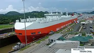
There are 800 km of waterways navigable by shallow draft vessels. The Panama Canal runs for 82 km across the country and is an important route for international freight ships traveling between the Atlantic and Pacific oceans.
Pipelines
The Trans-Panama pipeline carries crude oil for 130 km.
Atlantic Ocean
- Manzanillo (part of Colón province)
- Coco Solo
Merchant marine
Panama has an extensive international ship register, comprising 7,860 ships. Most are owned by foreign countries,[7] with Panama being a flag of convenience.
As of 2019, the ship types were: Bulk carrier (2,567), container ship (609), general cargo (1,325), oil tanker (798), and others (2,561).[8]
Air transport
Tocumen International Airport is the primary international airport, located just east of Panama City. It is the hub of flag carrier Copa Airlines. Scheduled services operate to destinations in the Americas, Europe, Asia and the Middle East.[9]
There are 117 airports across the country, 57 with paved runways and 60 with unpaved runways.[10]
References
- PROMTUR. "INFORMATION". VisitPanama. Retrieved 2020-12-26.
- "Pan-American Highway". Encyclopedia Britannica. Retrieved 2020-12-27.
- "Panama Transport Guide". Anywhere. 24 December 2020. Retrieved 24 December 2020.
- "Mapping out the future of Panama City's metro system". BNamericas. 24 July 2019. Retrieved 22 December 2020.
- "Panama: Country-specific information" Archived 2013-12-04 at the Wayback Machine. U.S. Department of State (March 18, 2009).
 This article incorporates text from this source, which is in the public domain.
 - "Archived copy". Archived from the original on 2011-09-28. Retrieved 2009-09-01.CS1 maint: archived copy as title (link)
- Panama Maritime Authority Main Headquarters (2020). THE TRUTH ABOUT THE MAURITIUS ISLAND AND THE SHIP REGISTRY. http://www.embassyofpanamainjapan.org/jp/wp-content/uploads/2020/08/0817-2020-THE-TRUTH-ABOUT-THE-MAURITIUS-ISLAND-AND-THE-SHIP-REGISTRY.pdf.CS1 maint: location (link)
- "Panama - Transportation - Merchant marine". The World Factbook - Central Intelligence Agency. 17 December 2020. Retrieved 22 December 2020.
- "Panama City Tocumen International Airport (PTY/MPTO) - Routes". Flightradar24. Retrieved 22 December 2020.
- "Panama - Transportation - Airports". The World Factbook - Central Intelligence Agency. 17 December 2020. Retrieved 22 December 2020.
External links
![]() Media related to Transport in Panama at Wikimedia Commons
Media related to Transport in Panama at Wikimedia Commons
![]() This article incorporates public domain material from the CIA World Factbook website https://www.cia.gov/the-world-factbook/.
This article incorporates public domain material from the CIA World Factbook website https://www.cia.gov/the-world-factbook/.
Transport in the Americas | ||
|---|---|---|
| ||
| Sovereign states |
| .svg.png.webp) |
| ||