Transport in Brazil
Transport infrastructure in Brazil is characterized by strong regional differences and lack of development of the national rail network.[1] Brazil's fast-growing economy, and especially the growth in exports, will place increasing demands on the transport networks.[2] However, sizeable new investments that are expected to address some of the issues are either planned or in progress.[2][3] It's common to travel domestically by air because the price is low. [4] Brazil got the second highest number of airports in the world, after USA. [5]
.jpg.webp)
.jpg.webp)
Railways

The Brazilian railway network has an extension of about 30,000 kilometers. It's basically used for transporting ores.[6] Usually, the railway sector is treated in a secondary way in Brazil, due to logistical, economic or political difficulties to install more railways.
- Total actual network: 29,303 km
- Broad gauge: 4,932 km 1,600 mm (5 ft 3 in) gauge (939 km electrified)
- Narrow gauge: 23,773 km 1,000 mm (3 ft 3 3⁄8 in) gauge (581 km electrified)
- Dual gauge: 396 km 1000 mm and 1600 mm gauges (three rails)
- Standard gauge: 202.4 km 1,435 mm (4 ft 8 1⁄2 in) gauge (2006)
- Estrada de Ferro do Amapá in the middle of the Amazon Rainforest also used standard gauge.
- A 12 km section of the former 2 ft 6 in (762 mm) gauge Estrada de Ferro Oeste de Minas is retained as a heritage railway.
Cities with metros
_03.jpg.webp)
|
|
Highways
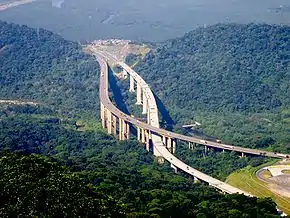
Brazil has more than 1.7 million km of roads, of which 215,000 km are paved, and about 14,000 km are divided highways. The two most important highways in the country are BR-101 and BR-116.[14]
The country has a low rate of car ownership of 140 per 1000 people, however in comparison to the other developing economies of the BRIC group Brazil exceeds India and China.
Waterways
50,000 km navigable (most in areas remote from industry or population) (2008)
Pipelines
- condensate/gas 62 km
- natural gas 9,892 km
- liquid petroleum gas 353 km
- crude oil 4,517 km
- refined products 4,465 km (2008)
Seaports and harbors
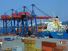
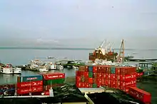
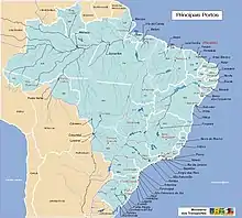
The busiest port in the country, and the 2nd busiest in all of Latin America, losing only to the Port of Colón, is the Port of Santos. Other high-movement ports are the Port of Rio de Janeiro, Port of Paranaguá, Port of Itajaí, Port of Rio Grande and Port of São Francisco do Sul.[15]
Atlantic Ocean
Paraguay River (international water way)
Merchant marine
total: 136 ships (1,000 gross tonnage (GT) or over) totaling 3,964,808 GT/6,403,284 tonnes deadweight (DWT)
ships by type: (1999 est.)
|
Airports
.jpg.webp)
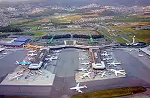
The country has the second largest number of airports in the world, behind only the United States. São Paulo/Guarulhos, is the largest and busiest in the country. Brazil has 44 international airports, such as those in Rio de Janeiro, Brasília, Belo Horizonte, Porto Alegre, Florianópolis, Cuiabá, Salvador, Recife, Fortaleza, Belém and Manaus, among others.
Most international flights must go to São Paulo–Guarulhos International Airport or Rio de Janeiro–Galeão International Airport. Belo Horizonte is the main international airport outside Rio de Janeiro and São Paulo. A few go to Brasília, Recife, Natal, and just recently Fortaleza has accepted international flights.
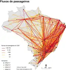
In 2013 Brazil had the sixth largest passenger air market in the world.[16]
Airports - with paved runways
- total: 734
- over 3,047 m: 7
- 2,438 to 3,047 m: 26
- 1,524 to 2,437 m: 169
- 914 to 1,523 m: 476
- under 914 m: 56 (2008)
Airports - with unpaved runways
- total: 3,442
- 1,524 to 2,437 m: 85
- 914 to 1,523 m: 1,541
- under 914 m: 1,816 (2008)
National airlines
- Azul Linhas Aéreas Brasileiras
- Gol Transportes Aéreos
- Avianca
- TAM Airlines (TAM Linhas Aéreas)
Heliports
- 16 (2007)
- 13 (2010)
See also
References
- "Logistics in Brazil - DHL Logistik". Archived from the original on 2012-07-24.
- "Archived copy" (PDF). Archived from the original (PDF) on 2012-09-22. Retrieved 2012-09-22.CS1 maint: archived copy as title (link)
- Home page | The world's leading construction web site
- "Travelling in Brazil - Transportation: Air, bus, car..." www.aboutbrasil.com. Retrieved 2020-10-13.
- "The World Factbook — Central Intelligence Agency". www.cia.gov. Retrieved 2020-10-13.
- The World Factbook — Central Intelligence
- "INTRODUCTION". www.tramz.com.
- "The Tramways of Belém". www.tramz.com.
- "The Tramways of Campinas". www.tramz.com.
- "Campos do Jordão". www.tramz.com.
- "CODESP hydroelectric complex (Brazil)". www.tramz.com.
- "THE SANTA TERESA TRAMWAY". www.tramz.com.
- "THE SCOTTISH TRAMS OF SANTOS". www.tramz.com.
- Anuário CNT do transporte 2018
- Port Activity of Latin America and the Caribbean 2018
- World Bank Datebase, http://data.worldbank.org/indicator/IS.AIR.PSGR
| History | |
|---|---|
| Agriculture | |
| Welfare | |
| Energy | |
| Other sectors | |
| Misc. |
|
| |
Transport in the Americas | ||
|---|---|---|
| ||
| Sovereign states |
| .svg.png.webp) |
| ||
External links
| Wikimedia Commons has media related to Transport in Brazil. |