Transport in Bolivia
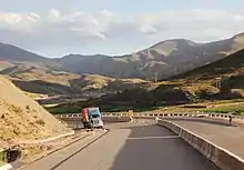
Transport in Bolivia is mostly by road. The railways were historically important in Bolivia, but now play a relatively small part in the country's transport system. Because of the country's geography, aviation is also important.
Railways
Total:
3,504 km (single track)
Narrow gauge (metre gauge):
- 3,504 km 1,000 mm (3 ft 3 3⁄8 in) gauge; (2006)
- The eastern and western networks are joined only via Argentina, due to slow progress on a direct link.
- The map on page 522 of the 1969/1970 edition of JANE'S shows a link between Cuevos and Zudañez as being "under construction".
Rail links with adjacent countries
- Argentina - yes - 1,000 mm (3 ft 3 3⁄8 in) both countries
- Brazil - yes - 1,000 mm gauge both countries
- Chile - yes - 1,000 mm gauge both countries; break of gauge where Chile is 1,676 mm (5 ft 6 in) gauge
- Peru - Shipping from 1,000 mm railhead in Guaqui to 1,435 mm (4 ft 8 1⁄2 in) railhead in Puno across Lake Titicaca, see Peru train ferry
Maps
Towns served by rail
Light Rail
Bolivia's first light rail network is under construction in Cochabamba, and is due to open in 2020.
Cable Car
Bolivia is home to Mi Teleférico, the world's first urban transit network to use cable cars as the primary mode of transportation. This system services the twin cities of El Alto and La Paz, and increased physical and social mobility within Bolivia.[1]
Roadways
total:
62,479 km
paved:
3,749 km (including 27 km of expressways)
unpaved:
58,730 km (2004)
Road construction in Bolivia is difficult due to its geography and lack of resources to completely develop an advanced road network. However, it maintains a small network of 4-lane freeways which are the following:
- 1 Oruro - Patacamaya (Expected to be completed in a few years, extending to La Paz). Length: 114 km.
- 4 Cochabamba - Quillacollo. Length: 14 km.
- 4 Santa Cruz de la Sierra - Montero. Length: 48 km.
The main national roads are:

- RN1 Desaguadero, border with Peru - La Paz - Oruro - Potosí - Tarija - Bermejo, border with Argentina.
- RN2 Copacabana, border with Peru - La Paz.
- RN3 La Paz - San Borja - Trinidad.
- RN4 Tambo Quemado, border with Chile - Cochabamba - Montero - Santa Cruz de la Sierra - Puerto Suárez, border with Brazil.
- RN5 La Palizada - Sucre - Potosí - Border with Chile.
- RN6 Oruro - Sucre - Chaco, border with Paraguay.
- RN7 Cochabamba - Samaipata - Santa Cruz de la Sierra.
- RN8 Yucumo - Riberalta - Guayaramerín, border with Brazil.
- RN9 Guayaramerín, border with Brazil - Trinidad - Santa Cruz de la Sierra - Yacuíba, border with Argentina
- RN10 Montero - San Matías, border with Brazil.
- RN 14 Potosí - Villazón, border with Argentina.
Waterways
10,000 km of commercially navigable waterways (2007)
Ports and harbors
Seaports
- In October 2010, Peru granted Bolivia port facilities and a free-trade zone as part of larger series of agreements strengthening bilateral relations between the two countries. Bolivia was granted about 1.4 square miles (3.6 km2) of port facilities on a 99-year lease at the Port of Ilo on Peru's southern Pacific coast. A similar agreement, signed by then Bolivian president Jaime Paz Zamora in 1992, never materialized for a lack of investment in infrastructure. Bolivia has free port privileges in the maritime ports of Argentina, Brazil, and Chile.
Lake Titicaca
Amazon basin
|
|
Paraguay River (international waterway)
Merchant marine
total:
23 ships (1,000 gross tonnage (GT) or over) totaling 116,373 GT/182,283 tonnes deadweight (DWT)
ships by type: (2008)
|
|
Airports
1,009 (2008)
|
Airports - with paved runways:
|
Airports - with unpaved runways:
|
Pipelines
- Crude oil 2,745 km
- Liquid petroleum gas 47 km
- Natural gas 4,883 km
- Refined products 1,589 (2008)
See also
References
- Neuman, William (Aug 16, 2014). "With Subway in the Sky, Valley Meets Plateau". New York Times. Retrieved 24 January 2018.
This article was adapted from the CIA World Factbook 2009.
External links
| Wikimedia Commons has media related to Transport in Bolivia. |

.svg.png.webp)