Turco Municipality
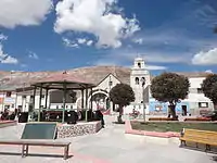
Turco Municipality is the second municipal section of the Sajama Province in the Oruro Department in Bolivia, and was founded on February 15, 1957.[1] Its seat is Turco, situated 154 km west of Oruro at an altitude of 3,860 m. The municipality covers an area of 3,973 km², not taking into account the area of Laca Laca Canton.[1][2]
Turco Municipality
Turku | |
|---|---|
Municipality | |
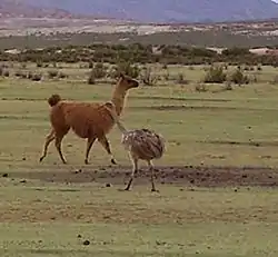 Darwin's rhea (Rhea pennata garleppi) photographed at the Tika Uta ranch, Turco Municipality | |
 Turco Municipality Location of the Turco Municipality within Bolivia | |
| Coordinates: 18°10′S 68°11′W | |
| Country | |
| Department | Oruro Department |
| Province | Sajama Province |
| Cantons | 4 |
| Created | February 15, 1957 |
| Seat | Turco |
| Area | |
| • Total | 1,534 sq mi (3,973 km2) |
| Elevation | 12,660 ft (3,860 m) |
| Population (2001) | |
| • Total | 4,160 |
| • Ethnicities | Aymara |
It is bordered to the north by the Curahuara de Carangas Municipality and San Pedro de Totora Province, to the south by the Litoral and Sabaya Provinces, to the west by Chile and to the east by the Carangas Province (Qhurqhi (Corque) and Chuqi Quta (Choquecota) Municipalities).
Geography
The most important rivers are Sajama, Cosapa, Lauca, K'uwiri and Qullpa Jawira (also named río Turco, Turco River) .
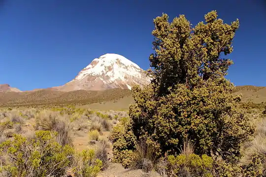
A couple of volcanoes and mountains of the Bolivian Western Mountain Range like Uqi Uqini and the volcanic complex of Kimsa Chata, a group of three mountains named Umurata, Acotango and Capurata in the west of the municipality are making up the natural border of Turco Municipality with Chile. Other mountains are listed below:[3]
- Ari Qullu Phujru
- Asu Asuni
- Chachakumani
- Chilli Qhata
- Chullkani
- Chunkarani
- Chuqil Qamiri
- Ch'alla Willk'i
- Ch'iyar Jaqhi
- Ch'iyar Jaqhi (near Qhapaqa)
- Ch'iyar Jaqhi (Umurata)
- Ch'iyar Qullu
- Jach'a K'uchu
- Jach'a Qullu
- Janq'u Jaqhi
- Janq'u Willk'i
- Kimsa Chata (Sajama)
- Kimsa Misa
- Kiswara
- Kuntur Ikiña
- Liyun Ikiña
- Mamaniri
- Ñuñu Qullu
- Ñuñutani
- Picha Qullu
- Pichaqani
- Pukarani
- Phaq'u Qullu
- Phasa Willk'i
- Q'ara Qullu
- Q'aysiri
- Q'ulin Ch'utu
- Qhapaqa
- Salla Qullu
- Tankani
- Taypi Qullu
- Taypi Qullu (near Junt'u Uta)
- Titiri
- Turi Turini
- Uqi Uqini
- Uqi Uqini (Bolivia)
- Uyarani
- Wankarani
- Warin Uma
- Waylla Sirka
- Wayna Chullunkhäni
- Wayna
- Wichhu Qullu
- Wila Lat'arata
- Wila Qullu (Qutallani)
- Wila Qullu (Turco)
- Willk'i
- Yapu Qullu
- Yaritani
Subdivision
The municipality is divided into four cantons and nine ayllus.
| Canton | Created [1] | Inhabitants (2001) [4] |
|---|---|---|
| Asunción Laca Laca | December 21, 1962 | 342 |
| Chachakumani | August 30, 1957 | 374 |
| Cosapa | November 11, 1950 | 918 |
| Turco | July 27, 1951 | 2,526 |
Flora and fauna
Part of Cosapa Canton is situated within Sajama National Park.[5] This park was created to conserve the rare woods of the queñua species Polylepis tarapacana and to protect species of wild flora and fauna like yareta (Azorella compacta), Andean hairy armadillo (Chaetophractus nationi), Darwin's rhea (Pterocnemia pennata), vicuña (Vicugna vicugna), taruca (Hippocamelus antisensis), Andean mountain cat (Felis jacobita) and cougar or puma (Felis concolor), all of them occurring in the municipality,[1] as well as their habitat.
The region has a rich diversity of native plants which are both useful for the inhabitants and the animals. The most important species are:[1]
| Common name | Scientific name | Usability |
|---|---|---|
| Añawaya | Adesmia spinosissima | forage for llamas |
| Waylla | Stipa obtusa | forage for llamas |
| Ichu | Stipa ichu | forage, handicraft |
| Iru ichu | Festuca orthophylla | forage, handicraft |
| Qanlli kiska | Tetraglochin cristatum | forage |
| Chillka | Senecio pampae | forage, medical plant |
| Yarita, yareta | Azorella asorella | medical plant, heating material |
| Tara tara | Fabiana densa | medical plant, heating material |
| Ñaka thula | Baccharis incarum | medical plant, heating material |
| Supu thula | Parastrephya lepidophylla | medical plant, heating material |
| Ayrampu | Opuntia soehrensii / Tunilla soehrensii | medical plant, forage |
| Muña muña | Satureja ovata | medical plant, forage |
| Itapallu | Cajophora horrida | medical plant, forage |
| Kinwa, queñua | Polylepis tarapacana | forage, heating material, ornamental |
| Chachakuma | Escallonia resinosa | medical plant |
| Llapa, pasto bandera | Boutelova simplex | forage |
| Yawarilla, cebadilla común | Bromus unioloides | forage |
| Cebadilla de montaña | Agrostis breviculmis | forage |
| Chiji blanco | Distichlis humilis | forage |
| Chiji negro | Mulenbergia fastigiata | forage |
| Garbancillo | Astragalus garbancillo | toxic |
| Lampaya | Lampaya medicinalis | medical plant, forage, heating material |
| Qura | Cajophora horrida | forage |
| K’achu | Anoda triangularis | forage |
The people
Most of the people in the municipality are of Aymara descent known as Carangas. They are mostly bilingual. According to census 2001 the main languages spoken are Spanish (3,544 speakers) and Aymara (3,259 speakers).[4]
Transport
_con_el_Nevado_Sajama_de_fondo.jpg.webp)
The international transit road from Oruro to Chile crosses Turco Municipality leading to Tambo Quemado situated in the Chachacomani Canton in the north-western part of the municipality [1][6] at the border between Chile and Bolivia.
See also
References
- Plan de desarollo municipal Municipio de Turco (Spanish)
- The data of the area of Laca Laca Canton were erroneously added to the Choquecota Municipality during the census of 2001.
- Bolivian IGM map 1:50,000 Chachacomani Hoja 5838-IV, Cerro Uyarani Hoja 5838-I, Estancia Antin Curahuara 5939-III, Estancia Agua Rica Hoja 5839-II, Estancia Laguna 5839-III, Estancia Marcarani 5939-IV, Estancia Miraflores 5838-II, Nevado Quimsachata Hoja 5738-I
- Instituto Nacional de Estadistica de Bolivia (INE) (Spanish)
- Mireya Muñoz, El Parque Nacional Sajama: Un caso de paisaje cultural en el altiplano de Bolivia p. 194
- In the map below Tambo Quemado erroneously is shown as part of Lagunas Canton in the Curahuara de Carangas Municipality (Sajama Province), but actually belongs to Turco Municipality.
External links
- Turco Municipality: population data and map (not showing Asunción Laca Laca Canton)
