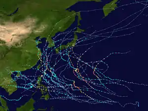
Typhoon Francisco (2019)
Typhoon Francisco was a small tropical cyclone that impacted Japan and the Korean Peninsula in August 2019. Originating from a trough over the open Pacific Ocean on July 29, Francisco developed into a tropical depression on August 1. Tracking along a northwest course toward Japan, the system steadily intensified over the following days. It attained typhoon strength on August 5 and soon struck Kyushu at peak strength with winds of 130 km/h (80 mph). Thereafter, the weakened storm traversed the Korea Strait before striking South Korea on August 6. Turning toward the east, Francisco transitioned into an extratropical cyclone on August 7. It later impacted Hokkaido before continuing across the northern Pacific and dissipating.
| Typhoon (JMA scale) | |
|---|---|
| Category 1 typhoon (SSHWS) | |
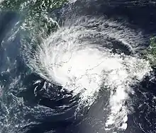
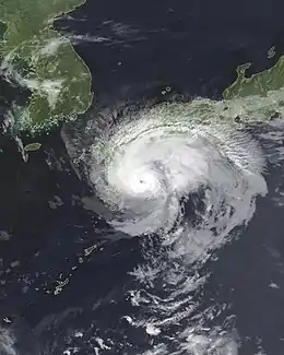 Typhoon Francisco shortly before landfall in Kyushu on August 5 | |
| Formed | August 1, 2019 |
| Dissipated | August 11, 2019 |
| (Extratropical after August 8) | |
| Highest winds | 10-minute sustained: 130 km/h (80 mph) 1-minute sustained: 150 km/h (90 mph) |
| Lowest pressure | 970 hPa (mbar); 28.64 inHg |
| Fatalities | 1 direct, 1 indirect |
| Damage | Unknown |
| Areas affected | Japan, Korean Peninsula, Russian Far East |
| Part of the 2019 Pacific typhoon season | |
In anticipation of Francisco impacting Japan, officials in Kyushu ordered evacuations for coastal residents in and around Miyazaki. Transportation across the region was disrupted, with flights and train service cancelled. The storm brought locally damaging winds and heavy rain. Wind gusts up to 143 km/h (89 mph) downed trees and power lines, leaving 24,710 households without power. Two people died and four others were injured in incidents related to the storm. Francisco also had minor impacts in the Korean Peninsula and Russia's Primorsky Krai.
Meteorological history
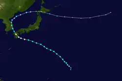
On July 29, 2019, the Joint Typhoon Warning Center (JTWC)[nb 1] began monitoring a trough approximately 695 km (432 mi) north-northwest of Wake Island. Situated in a region of low wind shear, favorable upper-level outflow, and traversing northwest over warm waters, development into a tropical cyclone over subsequent days was anticipated.[2] A defined low-level circulation developed the following day, with convective banding features organizing east of its center.[3] Development was temporarily halted on July 31 by insufficient divergence over a majority of the system.[4] Thereafter favorable conditions fostered organization.[5] The Japan Meteorological Agency (JMA)[nb 2] classified the system as a tropical depression at 00:00 UTC on August 1.[7] Similarly, the JTWC classified it as Tropical Depression 09W at 18:00 UTC.[8]
The JMA estimated the system to have become a tropical storm around 12:00 UTC on August 2. At this time, the agency assigned it the name Francisco.[7][nb 3] Traveling along a general northwest track toward Japan, the system steadily intensified and attained typhoon status around 09:00 UTC on August 5.[7] Typhoon Francisco reached its peak intensity around 12:00 UTC with ten-minute sustained winds of 130 km/h (80 mph)[nb 4] and a pressure of 970 mbar (hPa; 28.64 inHg).[7] The JTWC assessed the storm to have intensified slightly through 18:00 UTC, with maximum one-minute sustained winds of 140 km/h (85 mph).[8] Maintaining this intensity, Francisco made landfall in Miyazaki, Kyushu, around 20:00 UTC (5:00 a.m. local time, August 6).[12] Once overland, the system greatly weakened to a low-end tropical storm before emerging over the Korea Strait shortly after 06:00 UTC on August 6.[7]
Tropical Storm Francisco made landfall in Busan, South Korea, at 11:20 UTC (8:20 p.m. local time) on August 6.[13] Less than an hour after landfall, the Korea Meteorological Administration assessed Francisco to have degenerated into a remnant low;[13] however, the JMA and JTWC continued monitoring it as a tropical cyclone.[7][8] Emerging over the Sea of Japan early on August 7, the system weakened to a tropical depression.[7] The JTWC estimated Francisco to have remained a tropical storm for 12 more hours before transitioning into an extratropical cyclone;[8] however, the JMA maintained the system as a tropical cyclone until the following day as it turned east.[7] The storm's remnants later impacted Hokkaido on August 8–9 before continuing across the open Pacific.[14] The remnants of Francisco ultimately dissipated on August 11 well east of Japan.[7]
Preparations and impact
Japan
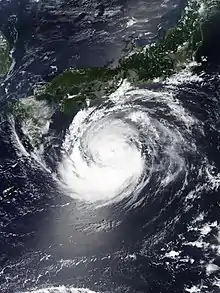
As the typhoon approached Japan, the JMA warned of heavy rainfall across Kyushu and parts of Shikoku. The agency noted a high risk of landslides, flooding, and the possibility of tornadoes.[15] In anticipation of coastal flooding, 20,020 people were evacuated from Kokuraminami-ku and Moji-ku.[16] Sixty-five public shelters opened across Kagoshima Prefecture.[17] Farther north, voluntary evacuations were issued for 10,500 households in Fukuoka, Kitakyushu, and Chukugo.[18] Kyushu Railway Company and Nishi-Nippon Railroad suspended operations on the night of August 5.[19][20] Local ferries were docked for the duration of the typhoon.[21] Multiple carriers collectively cancelled more than 110 flights at Miyazaki Airport, Fukuoka Airport, and Osaka International Airport.[22][23] Farmers in Ainan began rice harvests early due to the typhoon.[24] In Miyazaki City, the Prefectural Library and Prefectural Art Museum closed for the morning of August 6; however, they reopened later in the day after the typhoon's passage.[25] Repair works on Kumamoto Castle were suspended to prevent any equipment from damaging the structure.[26] The United States Navy raised the Tropical Cyclone Condition of Readiness for Fleet Activities Sasebo on August 3. These levels rose as the typhoon approached Japan.[27]
Striking Kyushu as a typhoon, Francisco brought heavy rain and strong winds to much of the island.[28] Rainfall peaked at 275 mm (10.8 in) in Nobeoka.[29] Most of the rain fell within a 12-hour span, notably 232 mm (9.1 in) in Kitaura.[30] Two cities observed record one-hourly rainfall accumulations: 120 mm (4.7 in) in both Nobeoka and Saiki.[31] These rains triggered flash flooding in Nobeoka, damaging four homes, inundating many roads, and submerging cars.[32][33] One person died of a heart attack when he was swept away by a flooded river in Kokonoe.[34][35] A maximum wind gust of 143 km/h (89 mph) was observed at Miyazaki Airport.[36] Many trees and signs were felled by the winds citywide, leaving debris strewn across roads. Some structures had windows shattered. Fallen trees took down power lines, leaving 24,710 homes without power.[37][38] Three people suffered injury, one seriously, after being knocked over by strong winds.[29] Strong winds in Fukuoka damaged a home and prompted the temporary closure of Kanmon Bridge.[39][40] Wind gusts in Saga Prefecture reached 99 km/h (62 mph).[41] Following the typhoon, officials in Miyazaki Prefecture established a relief fund for affected farmers.[42] Overall the rains proved beneficial for Fukuoka Prefecture which had been suffering from a drought. The combined rains from Danas, Francisco, and Lekima aided in filling Fukuoka Prefecture dam reached 81.2 percent capacity.[43]
Ahead of the typhoon's landfall in Kyushu, the system brought strong winds and heavy rain to the southern coast of Shikoku.[44] Cape Ashizuri in Tosashimizu experienced peak gusts of 100 km/h (62 mph).[45] Off the coast of Minamibōsō, Chiba, a fishing boat capsized amid rough seas produced by the typhoon on August 5. The boat's captain drowned and the one crew member suffered injury.[46] At Kobe University, a rowing boat with 23 students aboard capsized due to high winds; the students were able to swim 100 m (330 ft) to shore without injury.[47] Humid air brought north by the typhoon exacerbated the effects of a deadly heat wave in eastern Japan.[48] The remnants of Francisco later brought heavy rain to Hokkaido on August 8–9. Accumulations reached 147 mm (5.8 in) in Uryū.[14] Of this, 137.5 mm (5.41 in) fell within 12 hours, a record for that duration in the city.[49] The Uryu River swelled to near-flood stage, prompting evacuation orders for 240 households in Fukagawa and 80 more in Numata.[50]
Korean Peninsula
In anticipation of the storm's arrival, the Korean Meteorological Agency issued heavy rain warnings for eastern provinces and mountainous areas.[51] Seagoing vessels were advised to stay at port in the Korea Strait and western Sea of Japan.[52] TCCOR levels for Commander Fleet Activities Chinhae were raised beginning on August 5 and remained in place through the duration of the typhoon.[27] Precipitation was greatest along the east coast, peaking at 190 mm (7.5 in) at Seoraksan. Mountainous areas experienced the greatest winds, with gusts reaching 96 km/h (60 mph) at an unspecified location.[53] The overall effects of Francisco were limited; twelve structures sustained damage in Busan. Rain-slicked roads led to hazardous driving conditions, resulting in a few accidents. Two people were injured when a truck fell on its side.[54] Isolated flooding affected parts of Gangwon Province, with several people requiring rescue.[55] A baseball match between the Samsung Lions and NC Dinos was cancelled mid-game due to heavy rain.[56]
A weakening Francisco brought rainfall to parts of North Korea. Additional rainfall from Typhoon Lekima and subsequent storms led to flood concerns along the Tumen River in Rason.[57] Twenty-five North Korean fishing boats seeking to avoid the storm sought refuge in Olga Bay within Russia's Primorsky Krai.[58][59]
Russia
On August 7, the Russian Ministry of Emergencies warned of heavy rains and damaging winds in Primorsky Krai from the remnants of Francisco.[60] Seagoing vessels were advised to avoid travel along the Primorsky coast until the storm abated. The MS Maasdam was forced to dock early in Vladivostok.[61] Forty rescue personnel were preemptively deployed to Khasansky, Lazovsky, and Ussuriysk in anticipation of flooding.[62] Southern areas of Primorsky were most affected, with rainfall in some locations amounting to 60 percent of the August monthly average. Accumulations peaked at 91 mm (3.6 in) in Partizansk while Vladivostok saw 77 mm (3.0 in).[63] Most of the rain fell within a 12-hour period.[64] Many rivers in the region rose by 0.2–0.8 m (0.66–2.62 ft).[65] Some roads were submerged, including the A370 portion of the Trans-Siberian Highway between Khabarovsk and Vladivostok; the highway was temporarily shut down in this location.[66] A bridge near Krounovka was overtopped by a swollen river, isolating the village. A temporary boat crossing was established to ferry residents.[67] Eighteen tourists became stranded in Yezhovaya Bay due to flooded roads.[65] Several structures in Novostroyka experienced basement flooding.[68] In Vladivostok strong winds downed multiple trees, leaving some neighborhoods without power and damaging cars.[69][70]
Notes
- The Joint Typhoon Warning Center is a joint United States Navy – United States Air Force task force that issues tropical cyclone warnings for the western Pacific Ocean and other regions.[1]
- The Japan Meteorological Agency is the official Regional Specialized Meteorological Center for the western Pacific Ocean.[6]
- The name Francisco was submitted to the World Meteorological Organization by the United States and is a male name in the Chamorro language.[9]
- The Japan Meteorological Agency uses ten-minute sustained winds, while the Joint Typhoon Warning Center uses one-minute sustained winds.[10] The conversion factor between the two is 1.14.[11]
References
- "Joint Typhoon Warning Center Mission Statement". Joint Typhoon Warning Center. 2011. Archived from the original on July 26, 2007. Retrieved August 22, 2019.
- Significant Tropical Weather Advisory for the Western and South Pacific Oceans [at 2130 UTC] (Report). Joint Typhoon Warning Center. July 29, 2019.
- Significant Tropical Weather Advisory for the Western and South Pacific Oceans [at 2130 UTC] (Report). Joint Typhoon Warning Center. July 30, 2019.
- Significant Tropical Weather Advisory for the Western and South Pacific Oceans [at 0600 UTC] (Report). Joint Typhoon Warning Center. July 31, 2019.
- Significant Tropical Weather Advisory for the Western and South Pacific Oceans [at 1400 UTC] (Report). Joint Typhoon Warning Center. August 1, 2019.
- "Annual Report on Activities of the RSMC Tokyo - Typhoon Center 2000" (PDF). Japan Meteorological Agency. February 2001. p. 3. Retrieved August 22, 2019.
- "Typhoon 201908 (Francisco) - Detailed Track Information". Japan Meteorological Agency. Digital Typhoon. August 7, 2019. Retrieved August 22, 2019.
- "[Typhoon 09W (Francisco) Operational Best Track" (.dat). Joint Typhoon Warning Center. National Oceanic and Atmospheric Administration. August 8, 2019. Retrieved August 22, 2019.
- "List of names for tropical cyclones adopted by the ESCAP/WMO Typhoon Committee for the western North Pacific and the South China Sea (valid as of 2019)". Japan Meteorological Agency. 2019. Archived from the original on August 22, 2019. Retrieved August 22, 2019.
- "Frequently Asked Questions". Joint Typhoon Warning Center. 2005. Archived from the original on July 8, 2013. Retrieved August 22, 2019.
- "Section 2 Intensity Observation and Forecast Errors". United States Navy. 2009. Archived from the original on September 22, 2012. Retrieved August 22, 2019.
- "〔台風8号〕宮崎市付近に上陸、今年2個目の上陸台風(8/6)" (in Japanese). Yahoo! Japan. レスキューナウニュース. August 6, 2019. Retrieved August 9, 2019.
- 최동수 (August 8, 2019). "8호 태풍, 열대성저압부로 약화…울산 123.5㎜폭우(종합2보)" (in Korean). 머니투데이. Retrieved August 13, 2019.
- "北海道 元台風8号通過で大雨" (in Japanese). ウェザーニュース. August 9, 2019. Retrieved August 9, 2019.
- "厳重警戒 台風8号は強い勢力に 5日夜~6日九州に接近、上陸か" (in Japanese). Oricon. ウェザーマップ. August 5, 2019. Retrieved August 9, 2019.
- "台風8号、九州を進行中 北九州市、2万人に避難勧告". Asahi Shimbun (in Japanese). August 6, 2019. Retrieved August 6, 2019.
- "県内の自治体の避難情報" (in Japanese). Yahoo! Japan. MBC南日本放送. August 5, 2019.
- "台風8号 福岡県に最接近 高潮に警戒 北九州市では約1万500世帯に避難勧告も" (in Japanese). Nihsini Nippon. TNCテレビ西日本. August 6, 2019. Retrieved August 9, 2019.
- "【台風8号関連】JR、5日夜の運転見合わせ計画". Miyanichi Press (in Japanese). August 5, 2019. Retrieved August 9, 2019.
- "台風の影響で列車の遅れや運休も 5日夜から6日にかけ 天神大牟田線と貝塚線 西鉄が注意呼び掛け" (in Japanese). Yahoo! Japan. 西日本新聞. August 5, 2019.
- "台風8号 交通に影響(5日正午現在" (in Japanese). Yahoo! Japan. KTS鹿児島テレビ. August 5, 2019.
- "台風8号 交通機関に影響(正午時点の情報" (in Japanese). Yahoo! Japan. Miyazaki News Link. August 5, 2019.
- "台風8号、6日欠航110便超 九州発着中心に" (in Japanese). Aviation Wire. August 5, 2019. Retrieved August 9, 2019.
- "台風8号接近に備え…南予の一部で早期米の稲刈り前倒し【愛媛・愛南町】" (in Japanese). Yahoo! Japan. 株式会社 テレビ愛媛. August 5, 2019.
- "台風8号 交通機関の影響(5日午後6時現在)・宮崎" (in Japanese). Nikkei. August 5, 2019. Retrieved August 9, 2019.
- "台風に備え準備着々と…" (in Japanese). Yahoo! Japan. RKK熊本放送. August 5, 2019.
- David Ornauer (August 7, 2019). "Tropical Storm 09W (Francisco), # 23 FINAL". Stars and Stripes. Retrieved August 21, 2019.
- "台風8号 九州北部を通過中 四国にも発達した雨雲". tenki.jp (in Japanese). August 6, 2019. Retrieved August 6, 2019.
- "台風8号が九州縦断 大分で1人死亡 各地で豪雨と強風". Asahi Shimbun (in Japanese). August 6, 2019. Retrieved August 9, 2019.
- "台風8号が上陸した宮崎 延岡市北浦町で避難勧告 12時間232ミリの雨" (in Japanese). Yahoo! Japan. August 6, 2019.
- "台風8号 宮崎県と大分県に記録的短時間大雨情報" (in Japanese). Yahoo! Japan. ウェザーマップ. August 6, 2019.
- "台風8号 宮崎県を横断 延岡で浸水被害も" (in Japanese). Yahoo! Japan. MRT宮崎放送. August 6, 2019.
- "台風8号猛威、記録的大雨 住宅浸水、2人けが". Miyanichi Press (in Japanese). August 7, 2019. Retrieved August 9, 2019.
- "Typhoon leaves 1 dead in southwestern Japan". Japan Times. August 6, 2019. Retrieved August 6, 2019.
- "台風8号、大分で男性死亡" (in Japanese). Yahoo! Japan. TBS系(JNN). August 7, 2019.
- "Table of Hourly Weather Observations : 06 August 2019 Akae (Miyazaki Airport)". Japan Meteorological Agency. August 6, 2019. Archived from the original on August 6, 2019. Retrieved August 6, 2019.
- "台風8号ドキュメント・宮崎" (in Japanese). Yahoo! Japan. MRT宮崎放送. August 6, 2019.
- "台風8号の影響 北部平野部を中心に停電 宮崎" (in Japanese). Yahoo! Japan. Miyazaki News Link. August 6, 2019.
- "〔関門橋〕強風による通行止めは解除(6日15時現在)" (in Japanese). Rescue Now. レスキューナウニュース. August 6, 2019. Retrieved August 9, 2019.
- "台風8号九州縦断 大分で男性1人死亡、負傷者も相次ぐ" (in Japanese). Yahoo! Japan. 西日本新聞. August 7, 2019.
- "台風8号 佐賀県を縦断 最大瞬間風速27.5メートルを観測" (in Japanese). Yahoo! Japan. 佐賀ニュース サガテレビ. August 6, 2019.
- "台風8号被災の農家 低利融資県が制度適用". Miyanichi Press (in Japanese). August 16, 2019. Retrieved August 21, 2019.
- "福岡県ダム貯水率は平年超に 九州の今後の雨は?" (in Japanese). tenki.jp. August 19, 2019. Retrieved August 26, 2019.
- "台風8号 九州や四国 活発な雨雲 沿岸部で強風" (in Japanese). tenki.jp. August 5, 2019. Retrieved August 9, 2019.
- "強い台風8号 明け方に九州上陸へ 高知県では最大瞬間風速27.8m/s観測" (in Japanese). Yahoo! Japan. ウェザーニュース. August 5, 2019.
- "台風8号で高波に... 漁船転覆し船長死亡" (in Japanese). Yahoo! Japan. フジテレビ系(FNN). August 6, 2019.
- "台風の高波で神戸大のボート転覆 自力で100メートル泳ぐなどして23人全員無事". Asahi Shimbun (in Japanese). August 6, 2019. Retrieved August 9, 2019.
- "うだるような暑さ 大阪・万博記念公園に長さ70メートルのウォータースライダー" (in Japanese). Yahoo! Japan. YTV. August 5, 2019.
- "元台風で北海道は大雨 氾濫危険情報も" (in Japanese). tenki.jp. August 9, 2019. Retrieved August 9, 2019.
- "道内で大雨 深川市や沼田町に避難勧告" (in Japanese). HTB北海道テレビ放送. August 9, 2019. Retrieved August 9, 2019.
- 안영인 기자입 (August 7, 2019). "8호 태풍 소멸→전국 폭염 지속…'레끼마' 진로 예의주시" (in Korean). SBS News. Retrieved August 13, 2019.
- 최동수 (August 7, 2019). "8호 태풍, 부산 상륙…부산 114㎜·울산 104㎜ 물폭탄(종합)" (in Korean). 머니투데이. Retrieved August 13, 2019.
- "설악산 190mm 비…강원 영동 100mm 이상 폭우 예상(종합)" (in Korean). Yonhap News Agency. August 7, 2019. Retrieved August 21, 2019.
- 구경민 (August 7, 2019). "태풍 '프란시스코' 부산 상륙…9호 레끼마, 북상" (in Korean). 머니투데이. Retrieved August 13, 2019.
- "태풍 '프란시스코'…강원도 고립과 침수 피해 잇따라" (in Korean). 노컷뉴스. August 7, 2019. Retrieved August 21, 2019.
- 창원=김동영 (August 6, 2019). "[★현장] 6일 KBO 삼성-NC전 우천 취소... 태풍에 날아간 경기" (in Korean). 머니투데이. Retrieved August 13, 2019.
- "N. Korea issues special flood alert in downstream area of Tumen River". Yonhap News Agency. August 17, 2019. Retrieved August 21, 2019.
- "Тайфун "Франциско" загнал северокорейские шхуны к берегам Приморья" (in Russian). Вести. August 8, 2019. Retrieved August 22, 2019.
- "Лодки КНДР укрылись от тайфуна в приморском заливе Ольга" (in Russian). TVNZ. August 8, 2019. Retrieved August 22, 2019.
- "На Приморский край надвигается тропический шторм "Франциско"" (in Russian). Amur Info. August 7, 2019. Retrieved August 22, 2019.
- "Лайнер Maasdam зайдет во Владивосток на 5,5 часов раньше, чтобы не попасть в шторм" (in Russian). TACC. August 7, 2019. Retrieved August 22, 2019.
- "Аэромобильная группа спасателей в связи с приближающимся циклоном направляется в Уссурийск" (in Russian). Ussur Media. August 6, 2019. Retrieved August 22, 2019.
- "До 60% месячной нормы осадков выпало в Приморье из-за "Франциско"" (in Russian). East Russia. August 8, 2019. Retrieved August 22, 2019.
- "До Приморья докатилось лишь слабое эхо тайфуна "Франциско". Видеорепортаж Татьяны Дубко" (in Russian). Вести. August 8, 2019. Retrieved August 22, 2019.
- "Почти 20 туристов застряли на побережье в Приморье из-за ливней" (in Russian). Interfax Tourism. August 10, 2019. Retrieved August 22, 2019.
- "Тропический шторм "Франциско" в Приморье сняли на видео" (in Russian). ТВ Центр. August 8, 2019. Retrieved August 22, 2019.
- "Тайфун "Франциско" обрушился на Уссурийск ночью: ситуация на утро" (in Russian). Ussur Media. August 8, 2019. Retrieved August 22, 2019.
- Антон Никитин (August 10, 2019). "Ливень подтопил многоквартирные дома в одном из сел Приморья" (in Russian). Взгляд. Retrieved August 22, 2019.
- "В Приморском крае пытаются справиться с последствиями тайфуна "Франциско"" (in Russian). East Russia. August 8, 2019. Retrieved August 22, 2019.
- "Вода с крыши, машины разбиты, дороги под водой: тайфун шествует по Приморью". deita.ru (in Russian). August 9, 2019. Retrieved August 22, 2019.
External links
| Wikimedia Commons has media related to Typhoon Francisco (2019). |
- General Information of Typhoon Francisco (1908) from Digital Typhoon
