U.S. Route 5 in Vermont
U.S. Route 5 (US 5) is a part of the United States Numbered Highway System that runs from New Haven, Connecticut to the Canada–United States border at Derby Line, Vermont. In Vermont, the road runs south–north from the Massachusetts state line near Guilford to the international border. The 192.316 miles (309.503 km) that lie in Vermont are maintained by the Vermont Agency of Transportation (VTrans) and run largely parallel to Interstate 91. US 5 also follows the path of the Connecticut River from the Massachusetts border to St. Johnsbury, where the river turns northeast while US 5 continues north. The highway serves the major towns of Brattleboro, Hartford, and St. Johnsbury, along with the city of Newport near the Canadian border.
| ||||
|---|---|---|---|---|
| Calvin Coolidge Memorial Highway[1] | ||||
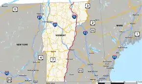 Map of Vermont with US 5 highlighted in red | ||||
| Route information | ||||
| Maintained by VTrans | ||||
| Length | 192.317 mi[2] (309.503 km) | |||
| Existed | 1926–present | |||
| Major junctions | ||||
| South end | ||||
| North end | ||||
| Location | ||||
| Counties | Windham, Windsor, Orange, Caledonia, Orleans | |||
| Highway system | ||||
| ||||

Before the development of the Numbered Highway System, US 5 was designated Route 2 and was part of the New England road marking system that existed from 1922 to 1927. When the Highway System was formed in November 1926, the former Route 2 was commissioned as US 5. At this point, the road was not paved. It was not paved until the state of Vermont started overseeing the maintenance of the highway in 1931. The road was completely paved by 1933.
Route description
US 5 winds through the far eastern part of Vermont, passing through many small towns and villages. The road runs through a fairly rural, wooded area throughout much of its path in Vermont.
Southern Vermont
US 5 enters the southern end of Vermont in Windham County at the Massachusetts–Vermont state line just north of Bernardston and just south of Guilford, Vermont.[3] The route is known as the Calvin Coolidge Memorial Highway from the Massachusetts border to the junction of Vermont Route 103 in Rockingham.[1] The road winds through wooded land along the west side of Interstate 91 for its first 8 miles in Vermont. In Brattleboro, Vermont's fourth largest town, US 5 crosses under the interstate and winds through Brattleboro's business district.[4] US 5 also starts a brief concurrency with Vermont Route 9 that continues for 2.3 miles.[5] North of Brattleboro, after VT 9 turns east, US 5 crosses back over the interstate to the west side.[4]
US 5 continues north from Brattleboro, passing near the small towns of Dummerston and Putney.[6][7] North of Putney, it crosses over I-91 to serve the towns of Westminster, Bellows Falls, and Rockingham.[8][9] Near Rockingham, US 5 intersects Vermont Route 103, which picks up the Calvin Coolidge Memorial Highway.[10] US 5 continues north on the east side of the interstate, crossing into Windsor County, for 6.6 miles to Springfield, where it crosses to the west side for just under a mile.[11] Here, it picks up a 0.8 mile concurrency with Vermont Route 11 and US 5 crosses back to the east side of Interstate 91 with Route 11.
Route 5 continues along the east side of Interstate 91 for 20 miles after its concurrency with Route 11. Along this stretch, US 5 passes through Wilgus State Park in Ascutney and the town of Windsor.[12] In Ascutney, US 5 picks up Vermont Route 12 for a 10-mile long concurrency. Route 12 winds along with US 5 through Windsor and across the interstate to Hartland, where it turns northwest away from US 5. North of Hartland, US 5 crosses Interstate 89 in White River Junction and intersects I-91 again.[13][14] Now on the east side of I-91, US 5 winds around the northwest edge of White River Junction, where it hooks up with U.S. Route 4. Routes 4 and 5 run concurrent for half a mile, crossing the White River. US 5 continues north to the town of Wilder, where it forms the main road of the town.[14] North of Wilder, US 5 crosses Interstate 91 twice. Just north of Norwich, US 5 crosses into Orange County and the town of Thetford. US 5 continues north, following the Connecticut River closely for 23 miles until it reaches the town of Bradford, passing through the small towns of North Thetford and Ely.[15]
Northern Vermont
For around 11 miles north of Bradford, US 5 passes through rural country along the Connecticut River before reaching the village of Wells River.[16] Here, US 5 has a very brief concurrency with U.S. Route 302. Continuing north, US 5 crosses into Caledonia County, then travels 11 miles before crossing to the west side of Interstate 91, passing through East Ryegate and Barnet.[17] US 5 crosses back and forth across the interstate a couple of times north of Barnet before US 5 and I-91 split at the Passumpsic River, about 2 miles north of Barnet. US 5 winds along the west bank of the Passumpsic, traveling through the town of Passumpsic. US 5 and I-91 meet up again 2 miles north of Passumpsic in the town of St. Johnsbury.[18] It is here in St. Johnsbury that the Connecticut River turns east away from US 5.
US 5 continues north along the Passumpsic River from St. Johnsbury for about 7.5 miles until it reaches the city of Lyndon.[19] In Lyndon, US 5 splits to the east away from Interstate 91. US 5 passes through West Burke, the Willoughby State Forest, and Barton before reaching the town of Orleans, 25 miles north of Lyndon.[20][21] Along this stretch, US 5 reaches Orleans County. In the town of Orleans, US 5 crosses to the west side of the interstate, concurrent with Vermont Route 58 for half a mile.[22] Route 5 continues north for 10 miles before reaching Newport.[23] Along this 10 mile stretch, the road passes through Coventry.[24] In Newport, US 5 picks up a 5-mile long concurrency with Vermont Route 105 that takes Route 5 across I-91 and into the village of Derby Center.[23][25] US 5 continues north, crossing I-91 for the last time 2.5 miles north of Derby Center. 6.5 miles north of Derby Center, in the village of Derby Line, US 5 reaches its northern terminus at the international border, across the border from Stanstead, Quebec.[26] US 5 continues past the Derby Line–Stanstead Border Crossing into Quebec as Quebec Route 143.
History
In 1922, before the United States Numbered Highway System's creation, US 5 traversed through Vermont as New England Route 2, the Connecticut River Way. 5 years later in 1927, at the creation of the highway system, Route 2 was almost completely overtaken by the new U.S. Route 5. At its original designation, US 5 mostly followed Route 2's path, except for a temporary routing into New Hampshire. From 1927 to 1929, US 5 crossed the Connecticut River at Bellows Falls, VT into North Walpole, NH and wound along the river to Charlestown, NH where it crossed back into Vermont.
US 5 was not maintained by the state of Vermont until the creation of the state highway system in 1931.[27] At this point, US 5 was not paved. The state of Vermont started paving the route in 1931 and it was completed by 1933.
Major intersections
| County | Location[2] | mi[2] | km | Destinations | Notes |
|---|---|---|---|---|---|
| Windham | Guilford | 0.000 | 0.000 | Continuation into Massachusetts | |
| Brattleboro | 7.709– 8.038 | 12.406– 12.936 | Interchange, Exit 1 on I-91 | ||
| 9.105 | 14.653 | Northern terminus of VT 142; western terminus of VT 119 | |||
| 9.282 | 14.938 | South end of VT 9 concurrency | |||
| 9.443 | 15.197 | Southern terminus of VT 30 | |||
| 11.591 | 18.654 | Roundabout; north end of VT 9 concurrency; eastern terminus of connector (VT 9090) to exit 3 on I-91 | |||
| Dummerston | 17.650 | 28.405 | Interchange, Exit 4 on I-91 | ||
| Putney | 18.431 | 29.662 | Westminster Road | ||
| Westminster | 28.431 | 45.755 | Western terminus of VT 123; to | ||
| 29.237 | 47.052 | Westminster Street | To Exit 5, | ||
| Rockingham | 31.839 | 51.240 | Eastern terminus of VT 121 | ||
| 32.671 | 52.579 | Rockingham Street | To | ||
| 35.470 | 57.083 | Southern terminus of VT 103; exit 6 on I-91 | |||
| Windsor | Springfield | 42.675 | 68.679 | West end of VT 11 concurrency | |
| 42.734– 43.101 | 68.774– 69.364 | Interchange, Exit 7 on I-91 | |||
| 43.479 | 69.973 | East end of VT 11 concurrency To | |||
| 49.017 | 78.885 | Eastern terminus of VT 143 | |||
| Weathersfield | 54.673 | 87.988 | Eastern terminus of VT 131; to I-91 Exit 8; South end of VT 12 concurrency | ||
| 55.823 | 89.838 | Southern terminus of VT 44A | |||
| Windsor | 59.691 | 96.063 | Eastern terminus of VT 44 | ||
| Hartland | 63.738 | 102.576 | Interchange; exit 9 on I-91 | ||
| 64.777 | 104.248 | North end of VT 12 concurrency | |||
| Hartford | No access between US 5 and I-89 | ||||
| 73.654– 73.842 | 118.535– 118.837 | Interchange; Exit 11 on I-91 | |||
| 74.382 | 119.706 | West end of US 4 concurrency | |||
| 74.943 | 120.609 | East end of US 4 concurrency; southern terminus of VT 14 | |||
| Norwich | 79.413 | 127.803 | Western terminus of VT 10A; exit 13 on I-91; partial cloverleaf interchange | ||
| River Road (VT 9540) | Northern terminus of unsigned VT 9540 | ||||
| 85.130 | 137.003 | Eastern terminus of VT 132 | |||
| Orange | Thetford | 89.674 | 144.316 | South end of VT 113 concurrency | |
| 89.729 | 144.405 | North end of VT 113 concurrency | |||
| Fairlee | 94.662 | 152.344 | Eastern terminus of VT 244 | ||
| 97.599 | 157.070 | Western terminus of VT 25A | |||
| Bradford | 103.065 | 165.867 | |||
| 104.035 | 167.428 | Eastern terminus of VT 25B | |||
| Town of Newbury | 116.874 | 188.090 | South end of US 302 concurrency | ||
| 117.003 | 188.298 | North end of US 302 concurrency | |||
| Caledonia | Barnet | 127.227 | 204.752 | North Monroe Road | To |
| 127.407 | 205.042 | Eastern terminus of unsigned VT 9020 | |||
| St. Johnsbury | 136.437– 136.657 | 219.574– 219.928 | Interchange, Exit 20 on I-91 | ||
| 137.449 | 221.203 | South end of US 2 concurrency | |||
| 137.563 | 221.386 | North end of US 2 concurrency | |||
| Lyndon | 144.865– 144.973 | 233.138– 233.311 | Interchange, Exit 23 on I-91 | ||
| 147.193 | 236.884 | Southern terminus of VT 114; southern terminus of VT 122 | |||
| Burke | 154.491 | 248.629 | Southern terminus of VT 5A | ||
| Orleans | Barton | 167.477 | 269.528 | South end of VT 16 concurrency | |
| 167.767 | 269.995 | North end of VT 16 concurrency | |||
| 172.548 | 277.689 | East end of VT 58 concurrency | |||
| 172.588– 172.886 | 277.753– 278.233 | Interchange, Exit 26 on I-91 | |||
| Irasburg | 173.057 | 278.508 | West end of VT 58 concurrency | ||
| Coventry | 177.710 | 285.997 | South end of VT 14 concurrency | ||
| 178.254 | 286.872 | North end of VT 14 concurrency | |||
| Newport (city) | 183.385 | 295.130 | West end of VT 105 concurrency | ||
| 184.484 | 296.898 | ||||
| Derby | 187.285– 187.502 | 301.406– 301.755 | Interchange, Exit 28 on I-91 | ||
| 188.389 | 303.183 | East end of VT 105 concurrency | |||
| 192.317 | 309.504 | Continuation into Quebec, Canada | |||
1.000 mi = 1.609 km; 1.000 km = 0.621 mi
| |||||
See also
 U.S. Roads portal
References
- "Named Highways and Bridges" (PDF). VTrans. April 28, 2008. Archived from the original (PDF) on March 17, 2012. Retrieved March 29, 2012.
- Traffic Research Unit (May 2013). "2012 (Route Log) AADTs for State Highways" (PDF). Policy, Planning and Intermodal Development Division, Vermont Agency of Transportation. Retrieved March 8, 2015.
- "Vermont General Highway Map - Guilford" (PDF). VTrans. 2003. Retrieved April 5, 2012.
- "Vermont General Highway Map - Brattleboro" (PDF). VTrans. 2011. Retrieved April 5, 2012.
- Overview Map of U.S. Route 5 Distances Between Intersections (Map). Google Maps. Retrieved April 5, 2012.
- "Vermont General Highway Map - Dummerston" (PDF). VTrans. 2008. Retrieved April 5, 2012.
- "Vermont General Highway Map - Putney" (PDF). VTrans. 2011. Retrieved April 5, 2012.
- "Vermont General Highway Map - Westminster" (PDF). VTrans. 2010. Retrieved April 5, 2012.
- "Vermont General Highway Map - Bellows Falls Village" (PDF). VTrans. 2010. Retrieved April 5, 2012.
- "Vermont General Highway Map - Rockingham" (PDF). VTrans. 2011. Retrieved April 5, 2012.
- "Vermont General Highway Map - Springfield" (PDF). VTrans. 2008. Retrieved April 5, 2012.
- "Vermont General Highway Map - Windsor" (PDF). VTrans. 2011. Retrieved April 5, 2012.
- "Vermont General Highway Map - Hartland" (PDF). VTrans. 2010. Retrieved April 5, 2012.
- "Vermont General Highway Map - White River Junction" (PDF). VTrans. 2011. Retrieved April 5, 2012.
- "Vermont General Highway Map - Bradford" (PDF). VTrans. 2010. Retrieved April 5, 2012.
- "Vermont General Highway Map - Wells River" (PDF). VTrans. 2011. Retrieved April 5, 2012.
- "Vermont General Highway Map - Barnet" (PDF). VTrans. 2008. Retrieved April 5, 2012.
- "Vermont General Highway Map - St. Johnsbury" (PDF). VTrans. 2010. Retrieved April 5, 2012.
- "Vermont General Highway Map - Lyndon" (PDF). VTrans. 2008. Retrieved April 5, 2012.
- "Vermont General Highway Map - West Burke" (PDF). VTrans. 2006. Retrieved April 5, 2012.
- "Vermont General Highway Map - Barton" (PDF). VTrans. 2010. Retrieved April 5, 2012.
- "Vermont General Highway Map - Orleans" (PDF). VTrans. 2009. Retrieved April 5, 2012.
- "Vermont General Highway Map - Newport City" (PDF). VTrans. 2009. Retrieved April 5, 2012.
- "Vermont General Highway Map - Coventry" (PDF). VTrans. 2011. Retrieved April 5, 2012.
- "Vermont General Highway Map - Derby Center" (PDF). VTrans. 2004. Retrieved April 5, 2012.
- "Vermont General Highway Map - Derby Line" (PDF). VTrans. 2011. Retrieved April 5, 2012.
- "Outline History of Vermont State Highways" (PDF). Vermont Dept. of Highways. 1965. p. 3. Retrieved April 1, 2012.
External links
| Wikimedia Commons has media related to U.S. Route 5 in Vermont. |
| Previous state: Massachusetts |
Vermont | Next state: Terminus |