Johnson County, Kansas
Johnson County is the most populous county in the U.S. State of Kansas. Largely suburban, the county contains a number of suburbs of Kansas City, Missouri including Overland Park, the second most populous city in the Kansas City Metropolitan Area.[1][2] Its county seat is Olathe.[3] As of the 2010 census, the county population was 544,179 with a 2019 estimate of 602,401 making it the most populous county in Kansas.[4][5] It is home to the headquarters of Garmin and AMC Theatres and was home to the Sprint Corporation before its merger with T-Mobile in 2020.[6][7][8]
Johnson County | |
|---|---|
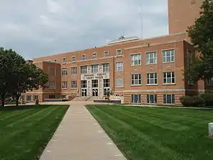 Johnson Courthouse in Olathe (2009) | |
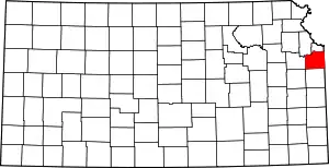 Location within the U.S. state of Kansas | |
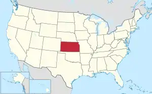 Kansas's location within the U.S. | |
| Coordinates: 38°52′00″N 94°52′00″W | |
| Country | |
| State | |
| Founded | August 25, 1855 |
| Named for | Thomas Johnson |
| Seat | Olathe |
| Largest city | Overland Park |
| Area | |
| • Total | 480 sq mi (1,200 km2) |
| • Land | 473 sq mi (1,230 km2) |
| • Water | 6.5 sq mi (17 km2) 1.4% |
| Population (2010) | |
| • Total | 544,179 |
| • Estimate (2019) | 602,401 |
| • Density | 1,100/sq mi (440/km2) |
| Time zone | UTC−6 (Central) |
| • Summer (DST) | UTC−5 (CDT) |
| Congressional district | 3rd |
| Website | jocogov.org |
In the mid-19th century, this was part of the Shawnee Reservation after their removal from east of the Mississippi River. The people were later forced to move to Indian Territory in present-day Ottawa County, Oklahoma.
History
This was part of the large territory of the Osage people, who occupied lands up to present-day Saint Louis, Missouri. After Indian Removal, the United States government reserved much of this area as Indian territory for a reservation for the Shawnee people, who were relocated from east of the Mississippi River in the upper Midwest.
The Santa Fe Trail and Oregon-California Trail, which pass through nearby Independence, Missouri, also passed through the county. Johnson County was established in 1855 as one of the first counties in the newly organized Kansas Territory; it was named for American missionary Thomas Johnson.[9] The renowned gunfighter Wild Bill Hickok settled for a time in the county, becoming constable of Monticello Township in 1858.
Johnson County was the site of many battles between abolitionists and pro-slavery advocates during the period of Bleeding Kansas, prior to the residents voting on whether slavery would be allowed in the territory. In 1862 during the American Civil War, Confederate guerrillas from nearby Missouri, led by William Quantrill, raided the Johnson County communities of Olathe and Spring Hill. They killed half a dozen men and destroyed numerous homes and businesses.[10]
The county was largely rural until the early 20th century, when housing subdivisions were developed in the northeastern portion of the county adjacent to Kansas City, Missouri. Developer J.C. Nichols spurred the boom in 1914 when he built the Mission Hills Country Club to lure upscale residents who previously had been reluctant to move from Missouri to Kansas.[11] Suburban development continued at a steady pace until the close of World War II.
Following the war, the pace of development exploded, triggered by the return of veterans in need of housing, construction of highways that facilitated commuting from suburbs, and the pent-up demand for new housing. The US Supreme Court ruling in Brown v. Board of Education (1954) ruled that segregation of public schools was unconstitutional. Integration of public schools in Kansas City, Missouri resulted in many white families leaving the inner city, resulting in increased migration to the county for new housing and what were considered higher quality public schools, generally an indicator of higher economic status. From the mid-1980s the pace of growth increased significantly, with the county adding 100,000 residents each decade between the 1990 census and 2010 census.
Geography

According to the U.S. Census Bureau, the county has a total area of 480 square miles (1,200 km2), of which 473 square miles (1,230 km2) is land and 6.5 square miles (17 km2) (1.4%) is water.[12]
Topography
The natural topography of the county consists of gently rolling terrain. The Kansas River forms a portion of the northwest boundary of the county. The elevation generally increases from north to south as the distance from the Kansas and Missouri rivers increases.
Watersheds and streams
The county is drained by the watersheds of the Kansas, Blue, and Marais des Cygnes, all of which are part of the Missouri River watershed. Located in northeastern Kansas, the county receives plentiful rainfall. The county contains numerous small streams, including Kill Creek, Mill Creek, Turkey Creek, Indian Creek, Brush Creek, Tomahawk Creek, the Blue River, Bull Creek and Little Bull Creek.
Kill Creek begins in the southwest portion of the county and flows northward into the Kansas River at De Soto. Mill Creek begins in the central portion of the county in Olathe, flowing northward it empties into the Kansas River at Shawnee. Turkey Creek and Brush Creek each begin in northeast Johnson County. Turkey Creek flows northeastward into Wyandotte County and joins the Kansas River just before its confluence with the Missouri River at Kaw Point. Brush Creek flows east-northeastward through Prairie Village and Mission Hills, entering Kansas City, Missouri within the median of Ward Parkway and passing the Country Club Plaza before emptying into the Blue River east of the Country Club Plaza and north of Swope Park. Indian Creek begins in the southern portion of Olathe and Tomahawk Creek begins in south Overland Park. Each flows northeastward meeting in Leawood, where the stream retains the name of Indian Creek, just before crossing the state line and entering the Blue River in Kansas City, Missouri. The Blue River begins in rural southern Johnson County and flows north-northeastward through the southeastern portion of the county and crossing the state line just east of the intersection of 151st Street and Kenneth Road in southern Overland Park. The Blue River flows through southern and eastern Kansas City before joining the Missouri River. Bull Creek and Little Bull Creek begin in rural southwestern Johnson County and flow southward where they enter Hillsdale Lake before continuing into Miami County, eventually joining the Marais des Cygnes at Paola.
Flora and fauna
The county consists primarily of prairie grassland with corridors of forested areas along streams and rivers.
Adjacent counties
- Wyandotte County (north)
- Jackson County, Missouri (east)
- Cass County, Missouri (southeast)
- Miami County (south)
- Franklin County (southwest)
- Douglas County (west)
- Leavenworth County (northwest)
Demographics
| Historical population | |||
|---|---|---|---|
| Census | Pop. | %± | |
| 1860 | 4,364 | — | |
| 1870 | 13,684 | 213.6% | |
| 1880 | 16,853 | 23.2% | |
| 1890 | 17,385 | 3.2% | |
| 1900 | 18,104 | 4.1% | |
| 1910 | 18,288 | 1.0% | |
| 1920 | 18,314 | 0.1% | |
| 1930 | 21,179 | 15.6% | |
| 1940 | 33,327 | 57.4% | |
| 1950 | 62,783 | 88.4% | |
| 1960 | 143,792 | 129.0% | |
| 1970 | 220,073 | 53.0% | |
| 1980 | 270,269 | 22.8% | |
| 1990 | 357,048 | 32.1% | |
| 2000 | 451,086 | 26.3% | |
| 2010 | 544,179 | 20.6% | |
| 2019 (est.) | 602,401 | [13] | 10.7% |
| U.S. Decennial Census[14] 1790-1960[15] 1900-1990[16] 1990-2000[17] 2010-2019[5] | |||

Johnson County (county code JO) is included in the Kansas City metropolitan area. The county has the highest median household income at $81,121 in 2017 and the highest per-capita income in Kansas, with the 19th highest median household income in 2000 and the 46th highest per-capita income in 2005. In 2010, Money magazine, in its list of the '100 Best Cities in the United States' in which to live, ranked Overland Park 7th (ranked 6th in 2006 and 9th in 2008) and Shawnee 17th (ranked 39th in 2008).[18] In 2008 the same magazine also ranked Olathe 11th.[19]
2010
As of the 2010 census, there were 544,179 people, 210,278 households, and 143,509 families residing in the county. The population density was 1,150 people per square mile (365/km2). There were 226,571 housing units at an average density of 381 per square mile (147/km2). The racial makeup of the county was 86.0% White, 4.2% Asian, 4.3% Black or African American, 0.4% Native American, 0.01% Pacific Islander, 1.55% from other races, and 2.5% from two or more races. Hispanic or Latino of any race were 7.2% of the population. 30.6% identified as of German, 16.8% Irish, 13.6% English and 5.7% American ancestry according to the 2010 census.[20]
There were 210,278 households, out of which 34.6% had children under the age of 18 living with them, 56.1% were married couples living together, 8.4% had a female householder with no husband present, and 31.8% were non-families. 25.9% of all households were made up of individuals, and 7.8% had someone living alone who was 65 years of age or older. The average household size was 2.51 and the average family size was 3.05.[20]
In the county, the population was spread out, with 26.3% under the age of 18, 7.60% from 18 to 24, 32.80% from 25 to 44, 22.50% from 45 to 64, and 10.9% who were 65 years of age or older. The median age was 36.4 years. 48.8% of the population were males and 51.2% of the population were females.
The median income for a household in the county was $73,733, and the median income for a family was $90,380. Males had a median income of $61,346 versus $43,785 for females. The per capita income for the county was $37,882. About 3.6% of families and 5.5% of the population were below the poverty line, including 7.1% of those under age 18 and 4.9% of those age 65 or over.[20]
2000
As of the census2 of 2000, there were 451,086 people, 174,570 households, and 121,675 families residing in the county. The population density was 365/km2 (946/mi2). There were 181,612 housing units at an average density of 147/km2 (381/mi2). The racial makeup of the county was 91.11% White, 2.61% Black or African American, 0.33% Native American, 2.83% Asian, 0.03% Pacific Islander, 1.55% from other races, and 1.54% from two or more races. 3.98% of the population were Hispanic or Latino of any race.
There were 174,570 households, out of which 36.00% had children under the age of 18 living with them, 59.20% were married couples living together, 7.80% had a female householder with no husband present, and 30.30% were non-families. 24.50% of all households were made up of individuals, and 6.70% had someone living alone who was 65 years of age or older. The average household size was 2.56 and the average family size was 3.09.
In the county the population was spread out, with 27.10% under the age of 18, 7.60% from 18 to 24, 32.80% from 25 to 44, 22.50% from 45 to 64, and 10.00% who were 65 years of age or older. The median age was 35 years. For every 100 females there were 95.50 males. For every 100 females age 18 and over, there were 92.00 males.
The median income for a household in the county was $61,455, and the median income for a family was $72,987. Males had a median income of $49,790 versus $32,145 for females. The per capita income for the county was $30,919. 3.40% of the population and 2.10% of families were below the poverty line. Out of the total population, 3.30% of those under the age of 18 and 3.60% of those 65 and older were living below the poverty line.
Government
Laws
Johnson County was a prohibition, or "dry", county until the Kansas Constitution was amended in 1986 and voters approved the sale of alcoholic liquor by the individual drink, with a 30% food sales requirement.[21]
Federal representation
| Year | Republican | Democratic | Third Parties |
|---|---|---|---|
| 2020 | 44.5% 155,631 | 52.7% 184,259 | 2.8% 9,496 |
| 2016 | 46.7% 137,490 | 44.1% 129,852 | 9.1% 26,866 |
| 2012 | 57.6% 158,401 | 40.2% 110,526 | 2.2% 6,147 |
| 2008 | 53.7% 152,627 | 44.7% 127,091 | 1.6% 4,493 |
| 2004 | 61.1% 158,103 | 37.8% 97,866 | 1.1% 2,718 |
| 2000 | 59.7% 129,965 | 36.4% 79,118 | 3.9% 8,453 |
| 1996 | 57.8% 110,368 | 35.7% 68,129 | 6.5% 12,397 |
| 1992 | 43.8% 85,418 | 30.6% 59,573 | 25.6% 49,875 |
| 1988 | 62.8% 95,591 | 36.3% 55,183 | 0.9% 1,425 |
| 1984 | 72.4% 101,987 | 27.0% 38,019 | 0.6% 876 |
| 1980 | 63.0% 78,048 | 26.8% 33,210 | 10.3% 12,725 |
| 1976 | 66.4% 75,798 | 31.2% 35,605 | 2.4% 2,739 |
| 1972 | 74.1% 76,161 | 23.7% 24,324 | 2.2% 2,242 |
| 1968 | 62.6% 55,060 | 29.6% 26,034 | 7.8% 6,818 |
| 1964 | 54.5% 37,672 | 45.1% 31,213 | 0.4% 294 |
| 1960 | 66.2% 43,026 | 33.7% 21,914 | 0.1% 93 |
| 1956 | 71.4% 35,511 | 28.5% 14,185 | 0.1% 37 |
| 1952 | 72.5% 29,103 | 27.4% 10,990 | 0.2% 70 |
| 1948 | 60.7% 14,191 | 38.4% 8,982 | 0.9% 205 |
| 1944 | 67.2% 11,951 | 32.5% 5,771 | 0.3% 51 |
| 1940 | 64.0% 10,326 | 35.8% 5,770 | 0.3% 46 |
| 1936 | 57.7% 8,399 | 42.0% 6,108 | 0.3% 47 |
| 1932 | 49.5% 6,487 | 49.5% 6,485 | 1.0% 124 |
| 1928 | 70.4% 8,185 | 29.0% 3,373 | 0.6% 69 |
| 1924 | 66.2% 6,102 | 27.3% 2,519 | 6.5% 603 |
| 1920 | 64.3% 4,325 | 34.2% 2,303 | 1.5% 101 |
| 1916 | 47.7% 3,767 | 49.7% 3,928 | 2.6% 205 |
| 1912 | 19.0% 834 | 41.9% 1,837 | 39.2% 1,719 |
| 1908 | 51.2% 2,313 | 46.3% 2,091 | 2.6% 116 |
| 1904 | 61.1% 2,573 | 32.6% 1,373 | 6.3% 267 |
| 1900 | 51.6% 2,393 | 46.8% 2,171 | 1.6% 75 |
| 1896 | 47.8% 2,313 | 50.9% 2,462 | 1.3% 62 |
| 1892 | 50.5% 2,070 | 49.5% 2,031 | |
| 1888 | 53.1% 2,164 | 35.2% 1,435 | 11.6% 474 |
| 1884 | 52.8% 2,110 | 34.8% 1,392 | 12.2% 489 |
| 1880 | 58.0% 2,132 | 32.1% 1,180 | 9.8% 360 |
Johnson County is a part of Kansas's 3rd congressional district, which elected Democrat Sharice Davids in the 2018 elections. The two U.S. Senators from Kansas are Republicans Roger Marshall and Jerry Moran. In the past, Johnson County has been solidly Republican. President George W. Bush received 61% of the vote in 2004, and has not supported a Democrat on the Presidential ticket since Woodrow Wilson in the 1916 election.[23][24] However, in 2016, Johnson County voted for then Republican presidential nominee Donald Trump by less than a three-point margin, as the GOP shifted towards right-wing populism. In 2020, former Vice President Joe Biden became the first Democrat to win Johnson County since Woodrow Wilson in 1916, winning Johnson County by an 8% margin.
State representation
Johnson County is home to 25 Kansas state representatives and 9 Kansas state senators. 13 out of 25 of Johnson County's representatives are Republicans, as are 6 of the county's 9 senators.[25][26] Numerous Republicans from the area identify as moderates, compared to some of the more ideological hard-liners from other parts of the state. Differences between moderates and the more hard-line members can most commonly be seen on social issues, the most infamous being the numerous debates about the state's school finance formula in 2004[27] and 2014–18.[28][29][30][31]
County government and unincorporated areas
The county government is administered by an elected, seven-member Board of County Commissioners, with six elected from single-member districts and one at-large.[32] Ed Eilert, former mayor of Overland Park, serves as the current County Chairman. Penny Postoak Ferguson has served as the county manager since 2018. Previously Hannes Zaccharias served this position from 2009 - 2018. Governance of the county is divided into six districts. The county government has full jurisdiction of the unincorporated areas of the county and limited jurisdiction of those areas of the county within incorporated places. For instance, decisions regarding the regulation of land use, development and zoning in unincorporated areas of the county are the responsibility of the county government, whereas such decisions for areas within incorporated places are the jurisdiction of the incorporated city of which the property is a part.
| District | Area Served | Commissioner | Term Expires |
|---|---|---|---|
| Chair | At-Large | Ed Eilert | January 2023 |
| One | Northeast | Becky Fast | January 2023 |
| Two | North | James Allen | January 2021 |
| Three | Southeast | Steven Klika | January 2021 |
| Four | East Central | Janeé Hanzlick | January 2023 |
| Five | West Central | Michael Ashcraft | January 2023 |
| Six | Western | Michael Brown | January 2021 |
Sales taxes
The current sales tax rate in Johnson County is 7.975%, higher than the 6.5% rate in Wyandotte (where Kansas City, Kansas is located).[33] The sales tax rates of each of the surrounding counties are nearly the same as the rate in Johnson County.[33] Individual cities have additional sales taxes.
Property taxes
Property taxes are a conglomeration of state, county, city, and school district taxes. Property tax rates are generally lower in Johnson County because property values in the county are higher than in other counties throughout Kansas.
| City | Commercial | Real Property | Motor Vehicle |
|---|---|---|---|
| De Soto | 3.20 | 1.47 | 3.84 |
| Gardner | 3.39 | 1.56 | 4.07 |
| Leawood | 3.39 | 1.56 | 4.07 |
| Lenexa | 2.75 | 1.26 | 3.30 |
| Merriam | 2.57 | 1.18 | 3.08 |
| Olathe | 3.09 | 1.42 | 3.71 |
| Overland Park | 2.31 | 1.06 | 2.77 |
| Prairie Village | 2.71 | 1.25 | 3.25 |
| Shawnee | 2.61 | 1.20 | 3.13 |
Note: Some cities have multiple tax rates because they are divided among multiple school districts. The above rates are what exist for the majority of residents in the city.
Crime
In 2019, the county announced that it is creating a new task force with shared jurisdiction between neighboring Miami and Franklin counties to combat crime.[35]
Education
.jpg.webp)
According to the 2010 Census Bureau, the education attainment of the population 25 years and over: 95.6% high school graduate or higher, 51.1% bachelor's degree or higher, and 17.9% graduate or professional degree.[20]
The Johnson County Library has 13 branches.[36]
Unified school districts
- Blue Valley USD 229
- Spring Hill USD 230
- Gardner-Edgerton USD 231
- De Soto USD 232
- Olathe USD 233
- Shawnee Mission USD 512
Colleges and universities
- Johnson County Community College
- University of Kansas Edwards Campus
- Kansas State University, Olathe Campus
- Kansas Christian College (Overland Park)
- MidAmerica Nazarene University
- Baker University, Overland Park Campus
- Ottawa University, Overland Park Campus
- Park University, Lenexa Campus
Transportation
Johnson County has a grid network through most of the county, with a road every mile. The grid has facilitated rapid growth and easy access. Interstate 435 runs through much of the county, and serves as a developmental "border" in the northbound–southbound portion. The westbound–eastbound part of I-435 divides the county into a northern and southern section. The northern section is older, while the southern portion is the fastest-growing area in Johnson County, containing a massive volume of new homes.
The Johnson County numbered street grid generally begins at 47th Street, the Wyandotte County line (the lowest numbered street is 40th Street in Bonner Springs), and is a continuation of the adjacent Kansas City, Missouri street grid. The grid continues to 215th Street, and into Miami County (with somewhat different named roads) to 407th Street at the Miami-Linn county line, with most suburban development ending around 167th Street. Named streets in the grid run from State Line Road (1900 West) to County Line Road (40699 West) at the Douglas County line. A portion of the grid extends north from Westwood into the Rosedale area in Kansas City, Kansas.
Another principal highway running through the area is Interstate 35, which runs diagonally through the county, entering it near Downtown Kansas City, Missouri and continuing through Olathe and Gardner. Outside the county, it eventually leads to Duluth, Minnesota in the north and the US–Mexico border in the south. U.S. 69 also serves Johnson County, entering from Wyandotte County at the south end of Interstate 635. Much of U.S. 69 within the county is freeway; this freeway eventually heads south and connects to Fort Scott and the rest of southeast Kansas.
Major highways
 I-35 Southwest corner with Franklin County northeast through Edgerton, Gardner, Olathe, Lenexa, Overland Park, and Merriam to the northeast corner with downtown Kansas City
 I-435 Northern border with Wyandotte County south through Shawnee and Lenexa to K-10 then east through Overland Park and Leawood to the Missouri border
 I-635 Starts in Johnson County at I-35 and enters Wyandotte County/Kansas City, KS less than 1000 feet later.
 US-50 Southwest corner with Franklin County northeast through Edgerton, Gardner, Olathe, Lenexa, Overland Park, and Merriam to the northeast corner with downtown Kansas City
 US-56 Southwest border with Douglas County east though Edgerton and Gardner to I-35
 US-69 Southeast border with Miami County north through Stilwell and Overland Park past I-435 to I-35
 US-169 Southern border with Miami County. Joins with I-35 in Olathe.
 K-7 Southern border with Miami County north through Spring Hill, Olathe, Lenexa, and Shawnee to Wyandotte County
 K-10 Western border with Douglas County east through De Soto, Lenexa, and Olathe to I-435
Other major roads
- Shawnee Mission Parkway – Interchange with K-7 in Shawnee east through Merriam, Mission, Fairway, and Mission Woods then joining up with Ward Parkway in Missouri
- Metcalf Avenue – Runs parallel with US-69 from Miami County north through Stilwell and Overland Park past I-435 and Shawnee Mission Parkway to join up with I-635 and I-35 in Wyandotte County
- Quivira Road – About 1⁄2 mile (0.80 km) mile north of Oak Grove Road in Kansas City, Kansas (as South 63rd Street, becomes Quivira Road at County Line Road/West 47th Street) to 183rd Street, with a second, rural southern section beginning at 187th Street and continuing to 239th Street in Miami County. The northern section is a major thoroughfare from Johnson Drive to 143rd Street, passing by Oak Park Mall at 95th Street and Johnson County Community College at College Boulevard.
- College Boulevard (formerly 111th Street, west of Tomahawk Creek Parkway) – State Line Road at Red Bridge Road in Leawood to Cedar Niles Parkway in Olathe. Takes its name from Johnson County Community College, at Quivira Road.
- 135th Street / Santa Fe Street – Interchange with State Line Road at MO-150 in south Kansas City, Missouri, west to Spoon Creek Road. Within the city limits of Olathe, 135th Street is legally known as Santa Fe Street. The numbering system changes to reflect the change in street name.
- 175/179th Street – Interchange with US-56 and I-35 as 175th St. east to Pflumm Rd. where it turns southeast to become 179th street then east to US-69 and Metcalf Ave.
- 199th Street – Intersection with US-56 in Edgerton east through Spring Hill and Stilwell to the Missouri border
- 119th Street – Major street that connects Olathe, Overland Park, and I-35 to each other.
- 151st Street – Major street that connects I-35 with U.S. 69 skirting the Johnson County Executive Airport and The Great Plains Mall.
- Lexington Ave/83rd Street/87th Street Parkway - Major street that runs from Douglas County through De Soto, Lenexa and Overland Park.
- 95th Street. Runs east and west from State line into Missouri, (east side) past 7 highway in Lenexa. (West side)
- 75th Street. Runs East and west from State line into Missouri, (east side) to Shawnee Mission Park. (west side).
- 159th Street. Runs east and west from Kenneth Road (east) into Missouri and to Baldwin City (West). Blue Valley High School and Blue Valley West High are located off 159th, as well as the New Century AirCenter in Gardner.
Airports
Johnson County is home to 3 general aviation airports:
The closest airport with airline service is Kansas City International Airport in Platte County, Missouri
Public transit
Johnson County Transit is the public transit operator.
Communities
Cities
- Bonner Springs (partly in Wyandotte County and Leavenworth County)
- De Soto (partly in Leavenworth County)
- Edgerton
- Fairway*
- Gardner
- Lenexa*
- Leawood*
- Lake Quivira* (partly in Wyandotte County)
- Merriam*
- Mission*
- Mission Hills*
- Mission Woods*
- Overland Park*
- Olathe
- Prairie Village*
- Roeland Park*
- Shawnee*
- Spring Hill (partly in Miami County)
- Westwood*
- Westwood Hills*
*Cities included in Shawnee Mission, a postal designation encompassing cities or regions thereof in northeastern Johnson County, headquarter post office located in Mission.
Townships
Johnson County was originally divided into nine townships, two of which have since been eliminated by the annexation of all their territory into independent municipalities. All of the cities are considered governmentally independent and are excluded from the census figures for the townships. In the following table, the population center is the largest city (or cities) included in that township's population total, if it is of a significant size.
| Township | FIPS | Population center |
Population | Population density /km2 (/sq mi) |
Land area km2 (sq mi) | Water area km2 (sq mi) | Water % | Geographic coordinates |
|---|---|---|---|---|---|---|---|---|
| Aubry | 03225 | 5,440 | 43 (112) | 126 (49) | 0 (0) | 0.31% | 38°46′48″N 94°41′4″W | |
| Gardner | 25450 | 2,143 | 21 (55) | 102 (39) | 1 (0) | 0.53% | 38°49′7″N 94°54′31″W | |
| Lexington | 39800 | De Soto | 3,712 | 10 (25) | 135 (52) | 2 (1) | 1.79% | 38°55′0″N 95°0′13″W |
| McCamish | 43625 | 878 | 8 (20) | 112 (43) | 0 (0) | 0.34% | 38°47′22″N 94°59′48″W | |
| Monticello (defunct) | 47950 | 0 | 0 (0) | 0 (0) | 0 (0) | 0% | 39°1′59″N 94°47′57″W | |
| Olathe | 52600 | 1,187 | 27 (70) | 44 (17) | 0 (0) | 0.04% | 38°54′21″N 94°49′18″W | |
| Oxford | 53825 | 2,020 | 121 (313) | 17 (6) | 0 (0) | 1.54% | 38°49′58″N 94°40′54″W | |
| Shawnee (defunct) | 64525 | 0 | 0 (0) | 0 (0) | 0 (0) | 0% | 39°1′51″N 94°47′47″W | |
| Spring Hill | 67650 | 2,059 | 29 (76) | 70 (27) | 0 (0) | 0.30% | 38°46′35″N 94°48′55″W | |
| Sources: "Census 2000 U.S. Gazetteer Files". U.S. Census Bureau, Geography Division. Archived from the original on 2002-08-02. | ||||||||
In popular culture
- Mission Hills is the setting for The ABC Family show Switched at Birth
- Netflix original documentary, Dirty Money, season 1 episode 2, entitled Payday, features the infamous predatory loan practices of Scott Tucker,[37] a resident of Leawood, Kansas. The episode features numerous aerial views of the area.
- The indie film All Creatures Here Below is partially set in De Soto, and filmed in Kansas City.[38]
See also
|
|
References
- "Home Page". Johnson County Kansas. Retrieved November 20, 2019.
- McCammon, Sarah (September 4, 2017). "As Kansas City Booms And Sprawls, Trying Not To Forget Those In Between". National Public Radio. Retrieved July 10, 2020.
- "Fast Facts". Johnson County Kansas. Archived from the original on July 16, 2019.
- https://www.census.gov/quickfacts/fact/table/johnsoncountykansas/PST045218
- "State & County QuickFacts". United States Census Bureau. Archived from the original on June 25, 2011. Retrieved July 26, 2014.
- "Sprint Headquarters and Corporate Office Info | Corporate Office Data".
- "Garmin Corporate Office Headquarters & Customer Service Info". 2017-07-28.
- "AMC Theatre Support Center".
- Gannett, Henry (1905). The Origin of Certain Place Names in the United States. Govt. Print. Off. pp. 169.
- "The Johnson County War: 1892 Invasion of Northern Wyoming | WyoHistory.org". www.wyohistory.org. Retrieved 2017-09-14.
- A Standard History of Kansas and Kansans – William E. Connelly – Lewis Publishing Company – 1918. 1918. Retrieved 2012-04-14.
- "US Gazetteer files: 2010, 2000, and 1990". United States Census Bureau. 2011-02-12. Retrieved 2011-04-23.
- "Population and Housing Unit Estimates". Retrieved March 26, 2020.
- "U.S. Decennial Census". United States Census Bureau. Retrieved July 26, 2014.
- "Historical Census Browser". University of Virginia Library. Retrieved July 26, 2014.
- "Population of Counties by Decennial Census: 1900 to 1990". United States Census Bureau. Retrieved July 26, 2014.
- "Census 2000 PHC-T-4. Ranking Tables for Counties: 1990 and 2000" (PDF). United States Census Bureau. Retrieved July 26, 2014.
- "Money Magazine". CNN. Retrieved June 8, 2011.
- "Best Places to Live 2008 – Kansas". Money Magazine. Retrieved 2008-08-11.
- "U.S. Census website". United States Census Bureau. Retrieved 2013-11-07.
- "Map of Wet and Dry Counties". Alcoholic Beverage Control, Kansas Department of Revenue. November 2006. Archived from the original on 2007-10-08. Retrieved 2007-12-28.
- Leip, David. "Dave Leip's Atlas of U.S. Presidential Elections". uselectionatlas.org.
- "Presidential Election Results by County 1960–Present". Uselectionatlas.org. 1999-01-24. Retrieved 2012-04-14.
- "Presidential Election Results by County Pre 1960". Geoelections.free.fr. Retrieved 2012-04-14.
- "Johnson County Election Office | State Representatives". www.jocoelection.org. Retrieved 2017-10-28.
- "Johnson County Election Office | State Senators". www.jocoelection.org. Retrieved 2017-10-28.
- Milburn, John (2004-08-24). "Lawmakers debate what constitutes 'suitable education'". .ljworld.com. Retrieved 2012-04-14.
- "Kansas to extend school-funding debate this week". Shawnee Dispatch. Retrieved 2018-04-14.
- "Capitol Update: Sen. Skubal says time has come for legislature to 'do its job to fully fund our schools'". Shawnee Mission Post - Neighborhood news and events for northeast Johnson County. 2018-01-15. Retrieved 2018-04-14.
- Sloan, Betsy Webster, Nick. "As school funding debate continues in Kansas, JoCo superintendents request $12M". Retrieved 2018-04-14.
- "Capitol Update: Rep. Rooker says 'devil is in the details' on Brownback budget proposal, including $600 million for schools". Shawnee Mission Post - Neighborhood news and events for northeast Johnson County. 2018-01-15. Retrieved 2018-04-14.
- "Board of County Commissioners". www.jocogov.org. Retrieved 2018-03-06.
- Kansas County Treasurer's Association Kansas Sales Tax Rates by County Archived 2011-08-07 at the Wayback Machine
- Kansas City Area Development Council ThinkKC Property Taxes Archived 2007-08-10 at the Wayback Machine (accessed 6/7/06)
- https://fox4kc.com/2019/03/29/johnson-county-forming-new-task-force-to-combat-violent-crime-keep-teens-safe/
- "Our Story". Johnson Countly Library. Retrieved 23 August 2014.
- "Payday loan mogul Scott Tucker can't pay for his own defense attorneys". kansascity. Retrieved 2019-03-09.
- https://www.thepitchkc.com/arts-entertainment/movies/article/21067709/david-dastmalchian-from-homeless-heroin-addict-to-antman-to-his-new-kansas-cityfilmed-all-creatures-here-below
Further reading
- Standard Atlas of Johnson County, Kansas; Geo. A. Ogle & Co; 78 pages; 1922.
- Standard Atlas of Johnson County, Kansas; Geo. A. Ogle & Co; 51 pages; 1902.
- Atlas Map of Johnson County, Kansas; E.F. Heisler; 86 pages; 1874.
External links
| Wikimedia Commons has media related to Johnson County, Kansas. |
- County
- Other
- Historical
- Maps
- Johnson County Maps: Current, Historic, KDOT
- Kansas Highway Maps: Current, Historic, KDOT
- Kansas Railroad Maps: Current, 1996, 1915, KDOT and Kansas Historical Society
Places adjacent to Johnson County, Kansas | |
|---|---|
Municipalities and communities of Johnson County, Kansas, United States | ||
|---|---|---|
| Cities | Map of Kansas highlighting Johnson County | |
| Unincorporated communities | ||
| Townships | ||
| Footnotes | ‡This populated place also has portions in an adjacent county or counties | |
| ||
Kansas City metropolitan area's cities and counties | ||
|---|---|---|
| Central city | 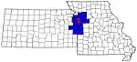 | |
| Largest cities (over 100,000 in 2000) | ||
| Medium-sized cities (10,000 to 100,000 in 2000) | ||
| Smaller Cities (between 5,000 and 9,900 in 2010) | ||
| Counties | ||
| Authority control |
|---|