Urbana Township, Champaign County, Illinois
Urbana Township is a township in Champaign County, Illinois, USA. As of the 2010 census, its population was 7,451 and it contained 3,435 housing units.[2]
Urbana Township | |
|---|---|
 Location in Champaign County | |
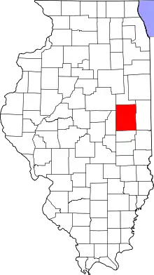 Champaign County's location in Illinois | |
| Coordinates: 40°05′54″N 88°10′24″W | |
| Country | United States |
| State | Illinois |
| County | Champaign |
| Established | November 8, 1859 |
| Area | |
| • Total | 24.07 sq mi (62.3 km2) |
| • Land | 24.03 sq mi (62.2 km2) |
| • Water | 0.04 sq mi (0.1 km2) 0.17% |
| Elevation | 705 ft (215 m) |
| Population (2010) | |
| • Estimate (2016)[1] | 7,136 |
| • Density | 310.1/sq mi (119.7/km2) |
| Time zone | UTC-6 (CST) |
| • Summer (DST) | UTC-5 (CDT) |
| FIPS code | 17-019-77018 |
Geography
Urbana is Township 19 North, Range 9 East of the Third Principal Meridian.
According to the 2010 census, the township has a total area of 24.07 square miles (62.3 km2), of which 24.03 square miles (62.2 km2) (or 99.83%) is land and 0.04 square miles (0.10 km2) (or 0.17%) is water.[2]
Portions of the township have been removed through annexation with the cities of Champaign and Urbana.
The University of Illinois South Farms occupy a large area south of the cities.
Yankee Ridge, a glacial moraine, extends through the central part of the township. Glacial rocks and large boulders frequently turn up on farms and construction sites in this area.
The Champaign County Poor Farm was in Section 16. The site on East Main Street in Urbana now has county offices, jail and nursing home.
The Kickapoo Rail Trail follows the former Big Four—Conrail System railroad right–of–way along U.S. Route 150 from the City of Urbana to the Village of St. Joseph.
Unincorporated towns
(This list is based on USGS data and may include former settlements.)
Cemeteries
The township contains several cemeteries: Eastlawn Burial Park and adjacent Greenwood—Harvey Cemetery (Section 9), Lincoln and Woodlawn (both Section 5), Mount Hope Cemetery and adjacent Roselawn (Section 18). All are now in the City of Urbana.
Potawatomi burial ground and Old Soldier's Burial Ground (Section 8). Burials were transferred to Mount Hope in 1902. The site is now Leal Park along University Avenue in Urbana.
Churches
Dunkard Church (Section 12 in 1893)
Grain Elevators
Myra Station elevator (Section 22) was built along the Wabash—Norfolk Southern railroad spur running between Urbana and Sidney 1881−1990. The elevator was operated by J.G. Holterman until December 1903 when it was taken over by Alfred Edmond Silver as Silver Elevator Company. The concrete elevator at the intersection of Illinois Route 130 and East Windsor Road was demolished in 1986. Myra Station depot on the opposite side of the tracks was named for Myra Silver (1834−1903) who owned a farm south of the depot in Section 26. On 30 November 1903 she was killed by a train approaching from the southeast as she was crossing the tracks to board at the station. The railroad spur was abandoned and the tracks taken up in the 1990s.
Urbana elevator (Section 8). H.R. Stinespring Coal, Flour and Feed elevator at 202 North Market Street (Broadway Avenue) in 1913 was south of both the Big Four and Wabash railroad tracks. The wooden elevator was still standing in 1968, but has since been demolished.
Mills
Runnel Fielder built a mill on the Saline Branch in Section 11 in the 1820s.
Charles Heptonstall built a water powered flour and sawmill on the Saline Branch about a mile downstream from the Urbana settlement in 1838. It later disappeared, probably washed away in a flood.
Jacob Mootz built a water–powered grist and sawmill on the Saline Branch around the year 1842. It was on land owned by Col. Matthew W. Busey in Section 8. The creek was dammed west of Market Street (Broadway Avenue) to form a millpond. The millpond and environs eventually evolved into Crystal Lake Park. Remains of the dam were still visible when Crystal Lake became an Urbana park in 1908. The lake occupies the original channel of the Saline Branch, cut off when the creek was straightened and channelized into its present course in 1909.
Schools
Rural schools in the township included Blackberry School (Section 1), Cottonwood School (Section 14), Perkins School (Section 4), Silver School (Section 26), Star School (Section 28), Union School No. 2 (Section 19), Willard School (Section 23).[3]
The rural schools were all demolished or converted to residences.
Major highways
 Interstate 74
 U.S. Route 45
 U.S. Route 150
 Illinois State Route 130
Airports and landing strips
- Day Aero-Place
References
- "Urbana Township, Champaign County, Illinois". Geographic Names Information System. United States Geological Survey. Retrieved 2010-01-04.
- United States Census Bureau cartographic boundary files
- "Population and Housing Unit Estimates". Retrieved June 9, 2017.
- "Population, Housing Units, Area, and Density: 2010 - County -- County Subdivision and Place -- 2010 Census Summary File 1". United States Census. Archived from the original on 2020-02-12. Retrieved 2013-05-28.
- Plat Book of Champaign County Illinois. Chicago: Geo. A. Ogle & Co., 1893. p. 55, Urbana Township
- "Census of Population and Housing". Census.gov. Retrieved June 4, 2016.
External links
Places adjacent to Urbana Township, Champaign County, Illinois | |
|---|---|
Municipalities and communities of Champaign County, Illinois, United States | ||
|---|---|---|
| Cities | Map of Illinois highlighting Champaign County | |
| Villages | ||
| Townships | ||
| CDPs | ||
| Other unincorporated communities | ||
| Ghost town | ||
| Footnotes | ‡This populated place also has portions in an adjacent county or counties | |
| ||