Waalre
Waalre (![]() pronunciation ) is an affluent municipality and town in the province of North Brabant in the southern Netherlands, immediately south of the city of Eindhoven.
pronunciation ) is an affluent municipality and town in the province of North Brabant in the southern Netherlands, immediately south of the city of Eindhoven.
Waalre | |
|---|---|
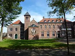 Former monastery in Waalre | |
 Flag Coat of arms | |
.svg.png.webp) Location in North Brabant | |
| Coordinates: 51°24′N 5°28′E | |
| Country | Netherlands |
| Province | North Brabant |
| Government | |
| • Body | Municipal council |
| • Mayor | Jan Brenninkmeijer (CDA) |
| Area | |
| • Total | 22.66 km2 (8.75 sq mi) |
| • Land | 22.39 km2 (8.64 sq mi) |
| • Water | 0.27 km2 (0.10 sq mi) |
| Elevation | 19 m (62 ft) |
| Population (January 2019)[4] | |
| • Total | 17,247 |
| • Density | 770/km2 (2,000/sq mi) |
| Demonym(s) | Waalrenaar |
| Time zone | UTC+1 (CET) |
| • Summer (DST) | UTC+2 (CEST) |
| Postcode | 5580–5583 |
| Area code | 040 |
| Website | www |
Population centres
- Aalst
- Waalre
Waalre is the so-called Groenfontein (Green fountain). This stems from its civic policy to provide a diverse tree population in streets and lanes.
Waalre is considered as one of the richest villages in The Netherlands due to the numerous millionaires living there. It was voted 7th best Dutch municipality to live in, according to a 2010 Elsevier research. The municipality is surrounded by woods, fields, and lakes. The nearest city is Eindhoven, which is situated on the other side of the A67 motorway.
The spoken language is Kempenlands (an East Brabantian dialect, which is very similar to colloquial Dutch).[5]
Town council
The current town council was elected at the 2014 local elections.
| Council seats | |||||
|---|---|---|---|---|---|
| Party | 1998 | 2002[6] | 2006[7] | 2010[8] | 2014[9] |
| D66 | 2 | 1 | 1 | 2 | 3 |
| Aalst-Waalre Belang | 4 | 4 | 2 | 5 | 3 |
| VVD | 4 | 4 | 4 | 4 | 3 |
| CDA | 2 | 3 | 3 | 3 | 3 |
| Zelfstandig Waalre | 0 | 0 | 0 | 0 | 2 |
| PvdA | 1 | 2 | 4 | 2 | 1 |
| GroenLinks | 0 | 0 | 1 | 1 | 1 |
| Nieuw Elan Waalre | 0 | 0 | 0 | 0 | 1 |
| Gemeente Belangen '74 | 4 | 3 | 2 | 0 | 0 |
| Total | 17 | 17 | 17 | 17 | 17 |
Waalre Town Hall
In July 2012 the town hall of Waalre was destroyed by a fire that resulted from two cars driving into the building from opposite ends at night.[10]
Notable people
- Geert Jan Jansen (born 1943 in Waalre) a Dutch painter and art forger, who was arrested in 1994 and convicted in 2000.
- John Baselmans (born 1954 in Aalst) a Dutch artist, sculptor, graphic designer and illustrator, lives in Curaçao
- Jan van den Dobbelsteen (born 1954 in Waalre) an interdisciplinary Dutch artist who teaches at Academy St. Joost
- Frans van Houten (born 1960) CEO of Royal Philips Electronics since 2011
- Martijn Oostra (born 1971 in Waalre) a Dutch graphic designer, photographer, artist and publicist
Gallery
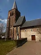 Oude Sint Willibrordus kerk, Waalre
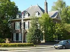 Eindhovenseweg, Waalre
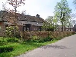 Heikant, a hamlet located between Waalre and Valkenswaard
 Eindhovenseweg, Aalst
References
- "Samenstelling B&W" [Members of the board of mayor and aldermen] (in Dutch). Gemeente Waalre. Retrieved 18 April 2014.
- "Kerncijfers wijken en buurten 2020" [Key figures for neighbourhoods 2020]. StatLine (in Dutch). CBS. 24 July 2020. Retrieved 19 September 2020.
- "Postcodetool for 5582LA". Actueel Hoogtebestand Nederland (in Dutch). Het Waterschapshuis. Retrieved 21 April 2014.
- "Bevolkingsontwikkeling; regio per maand" [Population growth; regions per month]. CBS Statline (in Dutch). CBS. 1 January 2019. Retrieved 1 January 2019.
- Jos & Cor Swanenberg: Taal in stad en land: Oost-Brabants, ISBN 9012090105
- NRC Handelsblad (2002) Gemeenteraadsverkiezingen 6 maart 2002
- NRC Handelsblad (2006) Gemeenteraadsverkiezingen 7 maart 2006
- Gemeente Waalre (2010) Verkiezingsuitslag 2010
- Gemeente Waalre (2014) Verkiezingsuitslag 2014
- "Town hall destroyed by fire after night-time attack by two cars". Dutch News . NL. Retrieved 18 December 2012.
External links
 Media related to Waalre at Wikimedia Commons
- Official website
Places adjacent to Waalre | |
|---|---|

| Authority control |
|---|