Geertruidenberg
Geertruidenberg (Dutch pronunciation: [ˈɣeːrtrœydə(m)ˌbɛrx] (![]() listen)) is a city and municipality in the province North Brabant in the south of the Netherlands. The city, named after Saint Gertrude of Nivelles, received city rights in 1213 from the count of Holland. The fortified city prospered until the 15th century.
listen)) is a city and municipality in the province North Brabant in the south of the Netherlands. The city, named after Saint Gertrude of Nivelles, received city rights in 1213 from the count of Holland. The fortified city prospered until the 15th century.
Geertruidenberg | |
|---|---|
City and Municipality | |
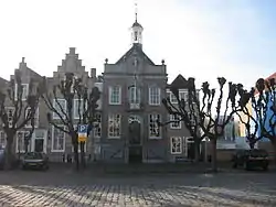 Former city hall on market square | |
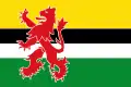 Flag  Coat of arms | |
.svg.png.webp) Location in North Brabant | |
| Coordinates: 51°42′N 4°52′E | |
| Country | Netherlands |
| Province | North Brabant |
| Government | |
| • Body | Municipal council |
| • Mayor | Jan Luteijn (acting) (SGP) |
| Area | |
| • Municipality | 29.64 km2 (11.44 sq mi) |
| • Land | 26.63 km2 (10.28 sq mi) |
| • Water | 3.01 km2 (1.16 sq mi) |
| Elevation | 3 m (10 ft) |
| Population (January 2019)[3] | |
| • Municipality | 21,515 |
| • Density | 808/km2 (2,090/sq mi) |
| Time zone | UTC+1 (CET) |
| • Summer (DST) | UTC+2 (CEST) |
| Postcode | 4930–4944 |
| Area code | 0162 |
| Website | www |
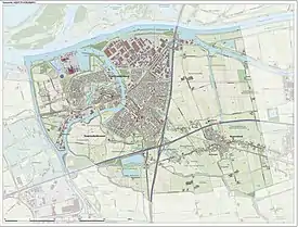
Today, the municipality of Geertruidenberg also includes the population centres Raamsdonk and Raamsdonksveer. The municipality has a total area of 29.64 km2 (11.44 sq mi) and had a population of 21,515 in 2019. The city government consists of the mayor Willemijn van Hees and three aldermen.
History
Geertruidenberg is named after Saint Gertrude of Nivelles.
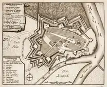
In 1213, Sint Geertruidenberg (English: "Saint Gertrude's Mountain") received city rights from Count William I of Holland. The fortified city became a trade center, where counts and other nobility gathered for negotiations. The Hook and Cod wars in 1420 and the Saint Elizabeth's flood in 1421 ended the prosperity of the city.[4]
During the Eighty Years War the city was captured by an English, French Huguenot and Fleming force in 1573 - in a surprise attack. In 1589 however the city was betrayed to Parma by its English garrison.[5] It was finally recaptured by an Anglo-Dutch force under the command of Maurice of Nassau in the summer of 1593.
Today, Geertruidenberg is part of the province of North Brabant, but it was once part of the county of Holland. Geertruidenberg is the second oldest city of Holland as it was the first to receive city rights. It is a common misconception that Geertruidenberg is the oldest city of the Netherlands, because the names Holland and the Netherlands are used interchangeably by some.
Geography
The total area of the municipality is 29.64 km2 (11.44 sq mi), of which 26.63 km2 (10.28 sq mi) is land and 3.01 km2 (1.16 sq mi) is water.
The municipality of Geertruidenberg comprises three population centres:
- Geertruidenberg
- Raamsdonk
- Raamsdonksveer
Geertruidenberg is located on the bank of the Donge, close to where this river flows into the Amer.
Demography
As of 2019, the total population of Geertruidenberg is 21,515 inhabitants. The population density of the municipality is 808/km2 (2,090/sq mi).
Government

The mayor of Geertruidenberg is Willemijn van Hees (VVD) and she was appointed mayor by the Dutch monarch, like all mayors in the Netherlands. The three aldermen of Geertruidenberg are Kevin van Oort (Groenlinks/D66), Adriaan de Jongh (CDA),and Bert van den Kieboom (Uw 3 Kernen). Together, the mayor and the aldermen form the College van Burgemeester en Wethouders, which is supported by the city's secretary Richard Nagtzaam.[6]
The city council is elected every four years during municipal elections, at the same time as in most other municipalities of the Netherlands. The 19 members of the city council assemble ten times per year for public meetings in the city hall in Raamsdonksveer. The council members come from eight political parties, three local and five national (2014):[7]
Notable people
- Johannes Vollevens (1649 in Geertruidenberg – 1728) a Dutch Golden Age painter
- Juliana de Lannoy (1738 – 1782 in St. Geertruidenberg) an artist and poet, lived in St. Geertruidenberg from 1758
- Willem Sassen (1918 in Geertruidenberg – 2002) a Dutch collaborator, Nazi journalist, a member of the Waffen-SS and the interviewer of Adolf Eichmann in 1960
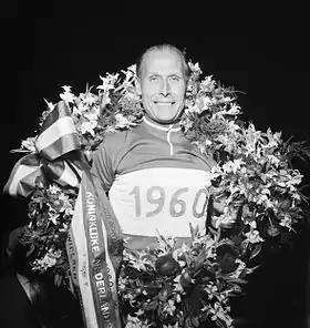
- Jan Derksen (1919 in Geertruidenberg – 2011) a Dutch professional cyclist, world professional track sprint champion in 1946 and 1957
- Matthijs Brouwer (born 1980 in Raamsdonk) a field hockey player, team silver medallist at the 2004 Summer Olympics
Gallery
.jpg.webp) Geertruidenberg
Geertruidenberg.jpg.webp) Geertruidenberg
Geertruidenberg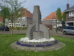 Geertruidenberg kunstwerk bloemenmonument
.jpg.webp) Dordrecht Brabantse Biesbosch
Dordrecht Brabantse Biesbosch
References
- "Kerncijfers wijken en buurten 2020" [Key figures for neighbourhoods 2020]. StatLine (in Dutch). CBS. 24 July 2020. Retrieved 19 September 2020.
- "Postcodetool for 4941DX". Actueel Hoogtebestand Nederland (in Dutch). Het Waterschapshuis. Archived from the original on 21 September 2013. Retrieved 19 May 2014.
- "Bevolkingsontwikkeling; regio per maand" [Population growth; regions per month]. CBS Statline (in Dutch). CBS. 1 January 2019. Retrieved 1 January 2019.
- "Vroeger en nu". www.geertruidenberg.nl (in Dutch). Municipality of Geertruidenberg. Retrieved 2008-08-16. External link in
|work=(help) - Israel, Jonathan (1995), The Dutch Republic: Its Rise, Greatness, and Fall 1477–1806, Clarendon Press, Oxford, ISBN 0-19-873072-1, p. 234
- "College van B&W". www.geertruidenberg.nl (in Dutch). Municipality of Geertruidenberg. Archived from the original on 2014-01-31. Retrieved 2014-02-03. External link in
|work=(help) - "Gemeenteraad". www.geertruidenberg.nl (in Dutch). Municipality of Geertruidenberg. Archived from the original on 2014-02-19. Retrieved 2014-02-03. External link in
|work=(help)
External links
 Media related to Geertruidenberg at Wikimedia Commons
- Official website

| Authority control |
|---|