Waitangi Park
Waitangi Park, a remodelled recreation space in Te Aro, Wellington, New Zealand, dates from 2006. It lies near Te Papa (the National Museum of New Zealand), Former Post and Telegraph Building and Courtenay Place. The facility includes a waka-launching area, a children's playground, a skateboard zone, and a large grassy space.
| Waitangi Park | |
|---|---|
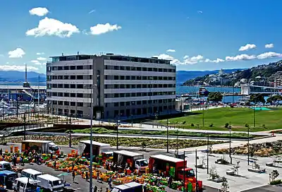 Waitangi Park in March 2007. In the foreground is the Sunday market. | |
| |
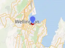
| Location | Wellington, New Zealand |
| Coordinates | 41.29137°S 174.78482°E |
| Area | 6.5 ha (16 acres) |
| Created | 2006 |
| Operated by | Wellington City Council |
Events
Numerous events have taken place at Waitangi Park, these include:
- In early 2006 the "Earth From Above" exhibition occurred at Waitangi Park. The exhibition consisted of a series of photographs by Yann Arthus-Bertrand and raised questions about sustainable development.[1]
- During the 2006 "International Festival of the Arts" a series of live performances, both by local artists (such as Salmonella Dub, The Warratahs, The Phoenix Foundation, Fat Freddys Drop) and by international acts selected from the festival (such as Antonio Forcione from Italy and The Sharon Shannon Band from Ireland)
Regular events include:
- Waitangi Park Market. Fruit and vegetable market. Open hours: Sunday 7am - 12pm.[2]
- Petanque
- Skateboarding
- Waka-launching
History
Wellingtonians formerly referred to the Waitangi Park area as Chaffers Park. Prior to 1855 the park area consisted of part of a gently sloping beach (Chaffers Beach), often covered in water from the harbour and stream.
Redevelopment into Waitangi Park
Wraight Athfield Landscape Architecture (WALA) won the competition held to design the park. WALA saw the design through to completion in 2005. The redevelopment of the park won a number of awards from the New Zealand Institute of Landscape Architects, the New Zealand Institute of Architects and the Wellington Civic Trust, among others.[3][4]
As part of the redevelopment, on the north-east side of the park the former Herd St Post Office was developed into lifestyle-apartments and into a commercial space called Chaffers Dock Apartments.
The redeveloped park was officially opened in March 2006. The redevelopment project cost a total of $22 million.[5]
The New Zealand Construction Industry Council (NZCIC) criticised the construction tendering process for the park, arguing that under-tendering caused problems. According to the NZCIC, the "initial tender accepted for the development at Waitangi Park was $2.1 million less than the estimated cost of the project, and at least $2.6 million below tenders from two other companies."[6]
Geography
The surrounding waterway (wetlands) is fed by the outflow from the Waitangi stream; recently lifted from stormwater drains and caused to flow through gravel and grass. The Waitangi stream flows from the Aro valley .
Waitangi Park is near the historic Waitangi Lagoon, fed by the Waitangi Stream. The lagoon used to harbour eel, fish, and shellfish, and was used by Māori for food gathering, fresh water, and waka launching. "Early English settlers planned to dig a canal along the path of the stream to allow boats to be anchored in the Basin Lagoon (now the Basin Reserve)", but the plan did not come to fruition.[7]
In 1855, an earthquake raised the land around the stream several metres, forcing the stream underground.[8] Waitangi Park is hence on reclaimed land.[7]
Further reading
- Price, Nina (2009). Waitangi Park: Public Land in Competition (Thesis).
References
- Festival Of The Arts 2006
- Waitangi Park Market
- "Waitangi Park". Wraight + Associates landscape architecture and urban design. Retrieved 15 January 2015.
- "Waitangi Park". New Zealand Institute of Landscape Architects. Retrieved 15 January 2015.
- "Waitangi Park opens in Wellington". New Zealand Herald. 15 March 2006. Retrieved 15 January 2015.
- "Waitangi Park costs: Value better than lowest cost". Scoop.co.nz (Press release). 1 March 2006.
- Burgess, Dave (3 November 2010). "Group plans to slip a few eels downtown". The Dominion Post. Retrieved 15 January 2015.
- "Waitangi Park – an urban wetland recreated". Enviro History NZ. 12 December 2010. Retrieved 15 January 2015.
External links
| Wikimedia Commons has media related to Waitangi Park. |
- Design Plan (pdf)
- Wellington Waterfront
- Festival Zone
- Well Urban Eye review of the Park
| Government |
|  | ||||||||
|---|---|---|---|---|---|---|---|---|---|---|
| Hospitals | ||||||||||
| Education | ||||||||||
| Public transportation | ||||||||||
| Culture |
| |||||||||
| Places |
| |||||||||
| ||||||||||
