Te Aro
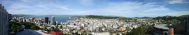
Te Aro is an inner-city suburb of Wellington, New Zealand. It comprises the southern part of the central business district including the majority of the city's entertainment district and covers the mostly flat area of city between The Terrace and Cambridge Terrace at the base of Mount Victoria.
Te Aro | |
|---|---|
Suburb | |
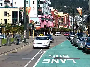 Dixon Street, looking towards Courtenay Place, in the heart of Te Aro | |
 Te Aro | |
| Coordinates: 41.294°S 174.777°E | |
| Country | New Zealand |
| Local authority | Wellington City |
| Population (2016[1]) | |
| • Total | 11,313 |
| Kelburn | Wellington Central | |
| Aro Valley |
|
Oriental Bay |
| Mount Cook | Mount Victoria |
Demographics
The population of Te Aro roughly doubled between 1991 and 1996 and again between 1996 and 2001. The rapid growth rate of population in the area has become particularly evident in the last five years as apartment buildings have been erected (or converted out of former office buildings) all over the suburb. Particularly characteristic are new rooftop apartments on existing buildings. These can be attributed to the relaxation of city by-laws governing commercial building-zones in the early 1990s. As of 2016 there are many apartment blocks planned for the area, some of which are at least 15 floors high.
Census facts
At the 2001 census:
- there were 3,024 people usually resident in Te Aro.[2]
- 16,281 people worked in Te Aro, the fourth-largest for any suburb in New Zealand, after Auckland Central, Wellington Central and Christchurch Central
- a quarter of the population were professionals
- 15% of the businesses in Wellington City were in Te Aro, 0.9% of all the businesses in New Zealand
- about one in 20 Te Aro residents had no qualifications
- 62% of Te Aro residents walked or jogged to work
- of the languages spoken by residents, 98.3% spoke English, 4.6% spoke French, 4.1% spoke Māori, 3.1% spoke German. Other languages were all spoken by less than 2% of the population.
(Statistical areas do not always coincide with the local council's definitions of suburbs.)
Major ethnic groups in Te Aro
| 77.7% | New Zealand European |
| 8.4% | Māori |
| 4.7% | Chinese |
| 3.1% | British/Irish |
| 2.2% | Indian |
| 1.8% | Samoan |
| 1.3% | Australian |
Entertainment district
Te Aro is New Zealand's largest entertainment district and thrives at night when the business district to the north closes down. Much of the nightlife is in the north of the suburb around Courtenay Place, Dixon Street, and lower Cuba Street. Saturdays are the biggest nights when most bars and clubs stay open to at least 3am.
Movies are a popular pastime in Te Aro, which boasts three commercial cinema complexes including the iconic Embassy Theatre, symbolic home of The Lord of the Rings film series.
Te Aro is home to several small theatres, including Circa, BATS, The Hannah Playhouse and Griffin. Larger venues include The Opera House on Manners Street and the St. James Theatre on Courtenay Place.
Waterfront
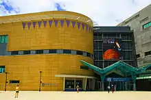
Te Aro is a coastal suburb, and has a popular publicly accessible waterfront area that boasts the Museum of New Zealand and the Overseas Passenger Terminal, a large function venue. A new outdoor recreation area, Waitangi Park, opened in 2006. The Wellington waterfront west of Taranaki Street, including Frank Kitts Park and Civic Square, is part of Wellington Central, not Te Aro.
The popular beach at Oriental Bay is five minutes' walk from the northeastern edge of Te Aro. Positively Wellington Tourism divides Te Aro into smaller areas – Courtenay Quarter, Courtenay Place, Waitangi Park – to help visitors find their way.
Politics
As the heart of the capital city, Te Aro is a highly politicised suburb. A number of issues in Te Aro have garnered national attention. The long-proposed and much-protested Wellington Inner City Bypass through Te Aro was a news story for decades, but is now accepted.
Former Wellington Mayor Kerry Prendergast was accused of nepotism for allowing high-rise development by her husband to go ahead in the predominantly low-rise area of southern Te Aro.
She was also criticised for forcibly ejecting a group of homeless people from an out-of-the-way park. This strategy backfired when the homeless took up residence in Cuba Street, in the heart of the retail area. The homeless now have regular altercations with retailers who accuse them of being drunk.
Transport
Te Aro is served by buses, which have taken the place of trams.
The Wellington tramway system served Te Aro from 1878 to 1964, with a number of routes to other Wellington suburbs. For over two decades, Te Aro was also served by the Te Aro Extension, a railway line from the New Zealand Railway's former Lambton station (not to be confused with the current Wellington station on Bunny Street) to Te Aro station. It opened in 1893; at its peak approximately 30 trains daily used the line, but local businesses complained of the dirt and noise of steam locomotives and the trains caused delays to traffic on important city streets. This led to the line's closure in 1917 and subsequent removal.
Some Wellington City Councillors have proposed re-extending rail services back to Courtenay Place and further, either as light rail or underground.[3]
Education
Te Aro School is a co-educational state primary school for Year 1 to 8 students,[4][5] with a roll of 236 as of March 2020.[6]
Neighbouring suburbs
- Wellington Central, the city's high-rise office district, is to the north. The boundary between the two halves of the central business district is at Civic Square where the ridge to the west comes closest to the sea.
- Kelburn is on the hills to the west, accessible via The Terrace and a few streets climbing from it, such as Salamanca Road and Bolton Street, and separated from Te Aro by Victoria University's main (Kelburn) Campus.
- Aro Valley lies beneath Kelburn to the southwest, and the turn into Aro Street marks the transition from Te Aro.
- Mount Cook is the low hill south of Te Aro; it contains the National War Memorial and Carillon, visible from much of southern Te Aro. Te Aro's southern boundary runs along Webb and Buckle Streets.
- Mount Victoria, the suburb on the western slope of the hill of the same name, is divided from Te Aro by the twin roads of Kent Terrace and Cambridge Terrace. The land for these roads was initially planned to be a channel into an inner harbour at the Basin Reserve. The plans were dropped when the 1855 earthquake lifted the land by several metres.
- Oriental Bay is the capital's inner-city beach suburb, accessible from Te Aro via Oriental Parade to the northeast.
References
- "Archived copy". Archived from the original on 2016-09-04. Retrieved 2016-11-20.CS1 maint: archived copy as title (link)
- "Willis Street–Cambridge Terrace Community Profile". 2003. Archived from the original on 2003-08-05.
- "Councillors signal light rail battle lines". Stuff. Retrieved 2017-09-14.
- "Te Aro School Official School Website". tearo.school.nz.
- "Te Aro School Education Review Office Report". ero.govt.nz. Education Review Office.
- "Te Aro School Ministry of Education School Profile". educationcounts.govt.nz. Ministry of Education.
Further reading
Kerr, Pete. 'Downtown discovery'. Heritage New Zealand. Autumn 2008. Issue 108, p. 4-9. Gives the history of Te Aro pa and the archaeological excavations in 2005.
