King County, Washington
King County is located in the U.S. state of Washington. The population was 2,252,782 in the 2019 census estimate, making it the most populous county in Washington, and the 12th-most populous in the United States. The county seat is Seattle,[1] also the state's most populous city.
King County | |
|---|---|
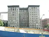
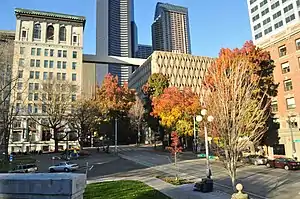 City Hall Park and King County Courthouse in downtown Seattle | |
 Flag Logo | |
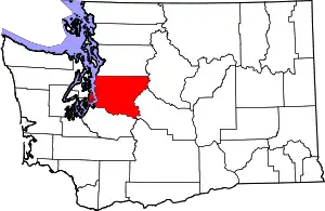 Location within the U.S. state of Washington | |
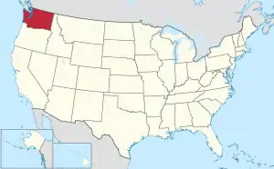 Washington's location within the U.S. | |
| Coordinates: 47°28′N 121°50′W | |
| Country | |
| State | |
| Founded | December 22, 1852 |
| Named for |
|
| Seat | Seattle |
| Largest city | Seattle |
| Area | |
| • Total | 2,307 sq mi (5,980 km2) |
| • Land | 2,116 sq mi (5,480 km2) |
| • Water | 191 sq mi (490 km2) 8.3%% |
| Population (2010) | |
| • Total | 1,931,249 |
| • Estimate (2019) | 2,252,782 |
| • Density | 1,034/sq mi (399/km2) |
| Time zone | UTC−8 (Pacific) |
| • Summer (DST) | UTC−7 (PDT) |
| Congressional districts | 1st, 7th, 8th, 9th |
| Website | www |
King County is one of three Washington counties that are included in the Seattle–Tacoma–Bellevue metropolitan statistical area. (The others are Snohomish County to the north, and Pierce County to the south.) About two-thirds of King County's population lives in Seattle's suburbs.
History
The county was formed out of territory within Thurston County on December 22, 1852, by the Oregon Territory legislature and was named after Alabamian William R. King, who had just been elected Vice President of the United States under President Franklin Pierce. Seattle was made the county seat on January 11, 1853.[2][3] The area became part of the Washington Territory when it was created later that year.
King County originally extended to the Olympic Peninsula. According to historian Bill Speidel, when peninsular prohibitionists threatened to shut down Seattle's saloons, Doc Maynard engineered a peninsular independence movement; King County lost what is now Kitsap County but preserved its entertainment industry.[4]
Coal was discovered in 1853 by Dr. M. Bigelow along the Black River, and in subsequent decades several companies formed to mine coal around Lake Washington and deliver it to Seattle. The Seattle and Walla Walla Railroad started servicing the Renton coal fields in 1877, and the Newcastle fields in 1878. By 1880, King County produced 22% of the coal mined on the West Coast, most of that coal being found within the Renton Formation's Muldoon coal seam.[5][6][7][8][9]
Namesake
On February 24, 1986, the King County Council approved a motion to rename the county to honor civil rights leader Martin Luther King Jr. (no relation to William R. King), preserving the name "King County" while changing its namesake.[10][11][12] The motion stated, among other reasons for the change, that "William Rufus DeVane King was a slaveowner" who "earned income and maintained his lifestyle by oppressing and exploiting other human beings," while Martin Luther King's "contributions are well-documented and celebrated by millions throughout this nation and the world, and embody the attributes for which the citizens of King County can be proud, and claim as their own."[13]
Because only the state can charter counties, the change was not made official until April 19, 2005, when Governor Christine Gregoire signed into law Senate Bill 5332, which provided that "King county is renamed in honor of the Reverend Doctor Martin Luther King, Jr." effective July 24, 2005.[14][15][16]
The County Council voted on February 27, 2006 to adopt the proposal sponsored by Councilmember Larry Gossett to change the county's logo from an imperial crown to an image of Martin Luther King, Jr.[17] On March 12, 2007, the new logo was unveiled.[18][19] The new logo design was developed by the Gable Design Group and the specific image was selected by a committee consisting of King County Executive Ron Sims, Council Chair Larry Gossett, Prosecutor Norm Maleng, Sheriff Sue Rahr, District Court Judge Corrina Harn, and Superior Court Judge Michael Trickey.[20] The same logo is used in the flag (illustrated).
Martin Luther King Jr. visited King County once, for three days in November 1961.[21][22]
Geography
According to the U.S. Census Bureau, the county has a total area of 2,307 square miles (5,980 km2), of which 2,116 square miles (5,480 km2) is land and 191 square miles (490 km2) (8.3%) is water.[23] King County has nearly twice the land area of the state of Rhode Island. The highest point in the county is Mount Daniel at 7,959 feet (2,426 meters) above sea level.
King County borders Snohomish County to the north, Kitsap County to the west, Kittitas County to the east, and Pierce County to the south. It also shares a small border with Chelan County to the northeast. King County includes Vashon Island and Maury Island in Puget Sound.
Geographic features

Terrain
Water
Major highways
Adjacent counties
- Snohomish County – north
- Pierce County – south
- Chelan County – east/northeast
- Kittitas County – east/southeast
- Kitsap County – west
National protected areas
- Klondike Gold Rush National Historical Park (part, also in Skagway, Alaska)
- Snoqualmie National Forest (part)
Demographics
| Historical population | |||
|---|---|---|---|
| Census | Pop. | %± | |
| 1860 | 302 | — | |
| 1870 | 2,120 | 602.0% | |
| 1880 | 6,910 | 225.9% | |
| 1890 | 63,989 | 826.0% | |
| 1900 | 110,053 | 72.0% | |
| 1910 | 284,638 | 158.6% | |
| 1920 | 389,273 | 36.8% | |
| 1930 | 463,517 | 19.1% | |
| 1940 | 504,980 | 8.9% | |
| 1950 | 732,992 | 45.2% | |
| 1960 | 935,014 | 27.6% | |
| 1970 | 1,156,633 | 23.7% | |
| 1980 | 1,269,749 | 9.8% | |
| 1990 | 1,507,319 | 18.7% | |
| 2000 | 1,737,034 | 15.2% | |
| 2010 | 1,931,249 | 11.2% | |
| 2019 (est.) | 2,252,782 | [24] | 16.6% |
| U.S. Decennial Census[25] 1790–1960[26] 1900–1990[27] 1990–2000[28] 2010–2019 | |||
The center of population of the state of Washington in 2010 was located in eastern King County (47.330750°N 121.619994°W).[29] King County's own center of population was located on Mercer Island (47.548320°N 122.229983°W).[30]
2010 census
As of the 2010 United States Census, there were 1,931,249 people, 789,232 households, and 461,510 families residing in the county.[31] The population density was 912.9 inhabitants per square mile (352.5/km2). There were 851,261 housing units at an average density of 402.4 per square mile (155.4/km2).[32] The racial makeup of the county was 68.7% White (64.8% Non-Hispanic White), 6.2% African American, 14.6% Asian, 0.8% Pacific Islander, 0.8% Native American, 3.9% from other races, and 5.0% from two or more races. Those of Hispanic or Latino origin made up 8.9% of the population.[31] In terms of ancestry, 17.1% were German, 11.6% were English, 11.1% were Irish, 5.5% were Norwegian, and 2.9% were American.[33]
Of the 789,232 households, 29.2% had children under the age of 18 living with them, 45.3% were married couples living together, 9.1% had a female householder with no husband present, 41.5% were non-families, and 31.0% of all households were made up of individuals. The average household size was 2.40 and the average family size was 3.05. The median age was 37.1 years.[31]
The median income for a household in the county was $68,065 and the median income for a family was $87,010. Males had a median income of $62,373 versus $45,761 for females. The per capita income for the county was $38,211. About 6.4% of families and 10.2% of the population were below the poverty line, including 12.5% of those under age 18 and 8.6% of those age 65 or over.[34]
Government
The King County Executive (currently Dow Constantine) heads the county's executive branch. The King County Prosecuting Attorney (currently Dan Satterberg), Elections Director (currently Julie Wise), Sheriff (currently Mitzi Johanknecht), and the King County Assessor (currently John Wilson) are elected executive positions. Judicial power is vested in the King County Superior Court and the King County District Court. Seattle houses the King County Courthouse.
King County is represented in the United States Congress through a near-entirety of the population in the 7th and 9th Congressional Districts, a majority of the population in the 8th Congressional District and a plurality of the population in the 1st Congressional District. In the state legislature, King contains the entirety of the 5th, 11th, 33rd, 34th, 36th, 37th, 41st, 43rd, 45th, 46th, 47th, and 48th legislative districts as well as the near-entirety of the 30th legislative district, about one-half of the 32nd legislative district, about one-third of the 1st and 31st legislative district, and a mere 627 people in the 39th legislative district. The only legislative districts represented by Republicans that include any part of King County are the 31st and 39th districts.
The people of King County voted on September 5, 1911 to create a Port District. King County's Port of Seattle was established as the first Port District in Washington State. The Port of Seattle is King County's only Port District. It is governed by five Port Commissioners, who are elected countywide and serve four-year terms. The Port of Seattle owns and operates many properties on behalf of King County's citizens, including Sea-Tac International Airport; many seaport facilities around Elliott Bay, including its original property, publicly owned Fishermen's Terminal, home to the North Pacific fishing fleet and the largest homeport for fishermen in the U.S. West Coast; four container ship terminals; two cruise ship terminals; the largest grain export terminal in the U.S. Pacific Northwest; three public marinas; 22 public parks; and nearly 5,000 acres of industrial lands in the Ballard-Interbay and Lower Duwamish industrial centers.
Council members
|
|
|
Politics
King County and Seattle are strongly liberal; the area is a bastion for the Democratic Party. No Republican presidential candidate has garnered the majority of the county's votes since Ronald Reagan's landslide reelection victory in 1984. In the 2008 election, Barack Obama defeated John McCain in the county by 42 percentage points, a larger margin than any previous election. Slightly more than 29% of Washington state's population reside in King County, making it a significant factor for the Democrats in a few recent close statewide elections. In 2000, King County's margin of victory pushed Maria Cantwell's total over that of incumbent Republican Slade Gorton, winning her a seat in the United States Senate. In 2004, King County gave a lead to Democrat Christine Gregoire in her 2004 victory gubernatorial election, pushing her ahead of Republican Dino Rossi, who led by 261 votes after the initial count.[35] Rossi resided in the county at the time of the election, in Sammamish.
In 2004, voters passed a referendum reducing the size of the County Council from 13 members to 9. This resulted in all council seats ending up on the 2005 ballot.
Some residents of eastern King County have long desired to secede and form their own county. This movement was most vocal in the mid-1990s (see Cedar County, Washington).[36][37] It has recently been revived as Cascade County.[38] According to a map published by the Seattle Times,[39] four different geographic borders are being considered. Additional plans (see Skykomish County, Washington) also exist or have existed.
| Year | Republican | Democratic | Third parties |
|---|---|---|---|
| 2020 | 22.2% 269,167 | 74.9% 907,310 | 2.8% 34,030 |
| 2016 | 21.8% 216,339 | 72.3% 718,322 | 6.4% 93,789 |
| 2012 | 28.4% 275,700 | 68.7% 668,004 | 2.9% 28,317 |
| 2008 | 28.0% 259,716 | 70.0% 648,230 | 2.0% 18,511 |
| 2004 | 33.7% 301,043 | 64.9% 580,378 | 1.5% 13,307 |
| 2000 | 34.4% 273,171 | 60.0% 476,700 | 5.6% 44,325 |
| 1996 | 31.4% 232,811 | 56.4% 417,846 | 12.2% 90,447 |
| 1992 | 27.4% 212,986 | 50.2% 391,050 | 22.4% 174,557 |
| 1988 | 44.8% 290,574 | 53.9% 349,663 | 1.3% 8,720 |
| 1984 | 52.1% 332,987 | 46.7% 298,620 | 1.2% 7,654 |
| 1980 | 45.4% 272,567 | 39.2% 235,046 | 15.4% 92,544 |
| 1976 | 50.8% 279,382 | 45.2% 248,743 | 4.0% 21,994 |
| 1972 | 56.4% 298,707 | 40.1% 212,509 | 3.5% 18,478 |
| 1968 | 46.0% 218,457 | 47.1% 223,469 | 7.0% 33,009 |
| 1964 | 39.4% 177,598 | 59.5% 268,216 | 1.1% 4,826 |
| 1960 | 50.9% 224,150 | 47.4% 208,756 | 1.8% 7,904 |
| 1956 | 55.3% 213,504 | 43.4% 167,443 | 1.4% 5,276 |
| 1952 | 53.9% 200,507 | 44.5% 165,583 | 1.5% 5,681 |
| 1948 | 44.9% 131,039 | 49.1% 143,295 | 5.9% 17,301 |
| 1944 | 41.4% 118,719 | 57.7% 165,308 | 0.9% 2,577 |
| 1940 | 39.5% 95,504 | 59.2% 143,134 | 1.3% 3,165 |
| 1936 | 31.7% 66,544 | 66.0% 138,597 | 2.3% 4,904 |
| 1932 | 34.4% 63,346 | 59.1% 108,738 | 6.5% 11,947 |
| 1928 | 65.6% 96,263 | 31.8% 46,604 | 2.6% 3,811 |
| 1924 | 53.5% 60,438 | 6.6% 7,404 | 39.9% 45,098 |
| 1920 | 54.7% 58,584 | 16.2% 17,369 | 29.1% 31,171 |
| 1916 | 40.7% 38,959 | 54.7% 52,362 | 4.6% 4,387 |
| 1912 | 21.9% 15,579 | 28.2% 20,088 | 50.0% 35,642 |
| 1908 | 55.8% 22,297 | 36.6% 14,644 | 7.6% 3,052 |
| 1904 | 70.4% 20,434 | 18.1% 5,266 | 11.5% 3,329 |
| 1900 | 54.3% 10,218 | 41.4% 7,804 | 4.3% 810 |
| 1896 | 44.8% 6,413 | 54.1% 7,733 | 1.1% 159 |
| 1892 | 44.2% 6,520 | 33.7% 4,974 | 22.1% 3,268 |
Religion
In 2010 statistics, the largest religious group in King County was the Archdiocese of Seattle, with 278,340 Catholics worshipping at 71 parishes, followed by 95,218 non-denominational adherents with 159 congregations, 56,985 LDS Mormons with 110 congregations, 25,937 AoG Pentecostals with 63 congregations, 25,789 ELCA Lutherans with 68 congregations, 24,909 PC-USA Presbyterians with 54 congregations, 18,185 Mahayana Buddhists with 39 congregations, 18,161 UMC Methodists with 50 congregations, 14,971 TEC Episcopalians with 35 congregations, and 12,531 ABCUSA Baptists with 42 congregations. Altogether, 37.6% of the population was claimed as members by religious congregations, although members of historically African-American denominations were underrepresented due to incomplete information.[41] In 2014, King County had 944 religious organizations, the 8th most out of all US counties.[42]
Education
K–12 schools
- Auburn School District
- Bellevue School District
- Enumclaw School District
- Federal Way Public Schools
- Highline School District
- Issaquah School District
- Kent School District
- Lake Washington School District
- Mercer Island School District
- Northshore School District
- Renton School District
- Riverview School District
- Seattle Public Schools
- Shoreline School District
- Snoqualmie Valley School District
- Tahoma School District
- Tukwila School District
- Vashon Island School District
Public libraries
Most of King County is served by the King County Library System, while the city of Seattle is served by its own system.
Communities
Cities
- Algona
- Auburn (partial)
- Bellevue
- Black Diamond
- Bothell (partial)
- Burien
- Carnation
- Clyde Hill
- Covington
- Des Moines
- Duvall
- Enumclaw
- Federal Way
- Issaquah
- Kenmore
- Kent
- Kirkland
- Lake Forest Park
- Maple Valley
- Medina
- Mercer Island
- Milton (partial)
- Newcastle
- Normandy Park
- North Bend
- Pacific (partial)
- Redmond
- Renton
- Sammamish
- SeaTac
- Seattle (county seat)
- Shoreline
- Snoqualmie
- Tukwila
- Woodinville
Census-designated places
- Ames Lake
- Baring
- Boulevard Park
- Bryn Mawr-Skyway
- Cottage Lake
- East Renton Highlands
- Fairwood
- Fall City
- Hobart
- Klahanie (former)
- Lake Holm
- Lake Marcel-Stillwater
- Lake Morton-Berrydale
- Lakeland North
- Lakeland South
- Maple Heights-Lake Desire
- Mirrormont
- Ravensdale
- Riverbend
- Riverton (former)
- Shadow Lake
- Tanner
- Union Hill-Novelty Hill
- Vashon
- Westwood
- White Center
- Wilderness Rim
Other unincorporated communities
- Cedar Falls
- Cumberland
- Denny Creek
- Ernie's Grove
- Grotto
- Kanaskat
- Kangley
- Lake Joy
- Naco
- Novelty
- Palmer
- Preston
- Selleck
- Spring Glen
- Wabash
Former cities and towns
References
- "Court Directory: County-City Reference List". Washington Courts. Retrieved May 7, 2017.
- "Milestones for Washington State History — Part 2: 1851 to 1900". HistoryLink.org. March 6, 2003.
- Reinartz, Kay. "History of King County Government 1853–2002" (PDF). Archived from the original (PDF) on December 1, 2007. Retrieved December 29, 2007.
- Bill Speidel, Doc Maynard, The Man Who Invented Seattle (Seattle: Nettle Creek Publishing Co., 1978) (ISBN 0-914890-02-6).
- Landes, Henry (1902). "The Coal Deposits of Washington, in Washington Geologic Survey Annual Report for 1901, Part IV". Retrieved 27 May 2020.
- Melder, F.E. (1938). "History of the Discoveries and Physical Development of the Coal Industry in the State of Washington". The Pacific Northwest Quarterly. 29 (2): 151–165. JSTOR 40486284.
- Smith, E. Eggleston. "Coals of the State of Washington, USGS Bulletin 474" (PDF). USGS. Retrieved 27 May 2020.
- Speidel, William (1967). Sons of the Profits. Seattle: Nettle Creek Publishing Company. pp. 144–151.
- Booth, Derek; Walsh, Timothy; Troost, Kathy; Shimel, Scott. "Geologic Map of the East Half of the Bellevue South 7.5' x 15' Quadrangle, Issaquah Area, King County, Washington,U.S. Geological Survey Scientific Investigations Map 3211, scale 1:24,000" (PDF). USGS. Retrieved 27 May 2020.
- "County's Name Is Same, But Meaning Is All New". Toledo Blade. Associated Press. February 25, 1986.
- "What's in a Name? King County renamed for civil rights leader". Spokane Chronicle. Associated Press. February 25, 1986.
- Sims, Ron. "Motion redesignating King County's name". Archived from the original on May 14, 2009. Retrieved September 24, 2009.
- "King County Council names county after Rev. Dr. Martin Luther King Jr. on February 24, 1986. - HistoryLink.org". www.historylink.org.
- "2005 Senate Bill 5332: Honoring the Reverend Doctor Martin Luther King, Jr". WashingtonVotes.org. Retrieved 2018-09-25.
- "Bill Information, SB 5332 - 2005-06 - Honoring the Reverend Doctor Martin Luther King, Jr". Washington State Legislature. Archived from the original on September 26, 2018. Retrieved September 25, 2018.
- ENGROSSED SENATE BILL 5332, 59th Legislature of the State of Washington, 2005 Regular Session.
- Ervin, Keith (February 28, 2006). "County logo to get makeover, show MLK". The Seattle Times. Archived from the original on March 14, 2006.
- "Executive praises County Council for approval of new logo". December 29, 2007. Archived from the original on November 2, 2007.
- "King County updates logo to reflect namesake", https://www.kingcounty.gov/about/logo.aspx (archive)
- "Background about the logo- King County - King County". www.kingcounty.gov.
- "Martin Luther King's Controversial Visit to Seattle: Rev. Samuel B. McKinney Tells the Story". The Daily. 2000-01-06.
- "Martin Luther King Jr. arrives for his sole Seattle visit on November 8, 1961". historylink.org. Retrieved March 13, 2020.
- "2010 Census Gazetteer Files". United States Census Bureau. August 22, 2012. Retrieved July 7, 2015.
- "American FactFinder". Retrieved April 8, 2020.
- "U.S. Decennial Census". United States Census Bureau. Retrieved January 7, 2014.
- "Historical Census Browser". University of Virginia Library. Retrieved January 7, 2014.
- "Population of Counties by Decennial Census: 1900 to 1990". United States Census Bureau. Retrieved January 7, 2014.
- "Census 2000 PHC-T-4. Ranking Tables for Counties: 1990 and 2000" (PDF). United States Census Bureau. Retrieved January 7, 2014.
- "Centers of Population by State: 2010". United States Census Bureau. Archived from the original on January 3, 2014. Retrieved March 22, 2014.
- "Centers of Population by County: 2010". United States Census Bureau. Archived from the original on March 22, 2014. Retrieved March 22, 2014.
- "DP-1 Profile of General Population and Housing Characteristics: 2010 Demographic Profile Data". United States Census Bureau. Archived from the original on February 13, 2020. Retrieved March 6, 2016.
- "Population, Housing Units, Area, and Density: 2010 – County". United States Census Bureau. Archived from the original on February 13, 2020. Retrieved March 26, 2016.
- "DP02 SELECTED SOCIAL CHARACTERISTICS IN THE UNITED STATES – 2006-2010 American Community Survey 5-Year Estimates". United States Census Bureau. Archived from the original on February 13, 2020. Retrieved March 6, 2016.
- "DP03 SELECTED ECONOMIC CHARACTERISTICS – 2006-2010 American Community Survey 5-Year Estimates". United States Census Bureau. Archived from the original on February 13, 2020. Retrieved March 6, 2016.
- "It's Rossi by 261; recount is next". The Seattle Times. November 18, 2004. Archived from the original on March 23, 2006.
- Radford, Dean (January 26, 2005). "Proposal would ease creation of new county". King County Journal. Archived from the original on April 4, 2005.
- Radford, Dean (February 6, 2005). "Calls for new county intensify – Rural rage revives drive to escape Seattle influence". King County Journal. Archived from the original on November 18, 2005.
- Cascadecounty.org Archived 2012-02-04 at the Wayback Machine
- "Cascade County (GIF)".
- Leip, David. "Dave Leip's Atlas of U.S. Presidential Elections". uselectionatlas.org.
- "County Membership Report King County (Washington)". The Association of Religion Data Archives. 2010. Retrieved January 2, 2020.
- "Social Capital Variables Spreadsheet for 2014". PennState College of Agricultural Sciences, Northeast Regional Center for Rural Development. December 8, 2017. Retrieved December 30, 2019.
External links
| Wikivoyage has a travel guide for King County. |
- King County website
- King County Snapshots presents King County, Washington, through 12,000 historical images carefully chosen from twelve cultural heritage organizations' collections. These catalogued 19th and 20th century images portray people, places, and events in the county's urban, suburban, and rural communities.
Places adjacent to King County, Washington | ||||||||||
|---|---|---|---|---|---|---|---|---|---|---|
| ||||||||||
Municipalities and communities of King County, Washington, United States | ||
|---|---|---|
| Cities |
| King County map |
| Towns | ||
| CDPs |
| |
| Unincorporated communities | ||
| Indian reservation | ||
| Ghost towns | ||
| Footnotes | ‡This populated place also has portions in an adjacent county or counties | |
| ||
| Authority control |
|---|