West Suffolk (district)
West Suffolk is a local government district in Suffolk, England, which was established on 1 April 2019, following the merger of the existing Forest Heath district with the borough of St Edmundsbury.[1] The two councils had already had a joint Chief Executive since 2011.[2] At the 2011 census, the two districts had a combined population of 170,756.
West Suffolk | |
|---|---|
 | |
 | |
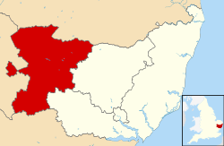 West Suffolk district within Suffolk | |
| Sovereign state | United Kingdom |
| Constituent country | England |
| Region | East of England |
| Non-metropolitan county | Suffolk |
| Status | Non-metropolitan district |
| Admin HQ | Bury St Edmunds |
| Incorporated | 1 April 2019 |
| Government | |
| • Type | Non-metropolitan district council |
| • Body | West Suffolk District Council |
| Area | |
| • Total | 400 sq mi (1,035 km2) |
| Area rank | 28th (of 317) |
| Population (mid-2019 est.) | |
| • Total | 179,045 |
| • Rank | 107th (of 317) |
| • Density | 450/sq mi (170/km2) |
| • Density rank | 263rd |
| Time zone | UTC0 (GMT) |
| • Summer (DST) | UTC+1 (BST) |
| Website | www |
The main towns in the new district are Bury St Edmunds, Newmarket, Brandon, Haverhill and Mildenhall.
The district covers a smaller area compared to the former administrative county of West Suffolk, which was abolished by the Local Government Act 1972.
List of Wards
The council area is divided up into 43 wards and represented by 64 councillors.[3]
- Abbeygate
- Bardwell
- Barningham
- Barrow
- Brandon Central
- Brandon East
- Brandon West
- Chedburgh and Chevington
- Clare, Hundon and Kedington
- Eastgate
- Exning
- Haverhill Central
- Haverhill East
- Haverhill North
- Haverhill South
- Haverhill South East
- Haverhill West
- Horringer
- Iceni
- Ixworth
- Kentford and Moulton
- Lakenheath
- Manor
- Mildenhall Great Heath
- Mildenhall Kingsway and Market
- Mildenhall Queensway
- Minden
- Moreton Hall
- Newmarket East
- Newmarket North
- Newmarket West
- Pakenham and Troston
- Risby
- Rougham
- Southgate
- St Olaves
- Stanton
- The Fornhams and Great Barton
- The Rows
- Tollgate
- Westgate
- Whepstead and Wickhambrook
- Withersfield
Communities
The district council area is made up of 5 towns and 97 civil parishes, with the whole area being parished.
Governance
As of its 2019 creation, the Conservative Party control West Suffolk Council.[4] The result of the council elections held on 2 May 2019 are shown in the table below.
| Party | Seats |
|---|---|
| Conservative | 36 |
| Independent | 15 |
| West Suffolk Independents | 7 |
| Labour | 5 |
| Green | 1 |
See also
- 2019 structural changes to local government in England
- East Suffolk, another district that was created in Suffolk on 1 April 2019.
References
- Ministry of Housing, Communities and Local Government (24 May 2018). "The West Suffolk (Local Government Changes) Order 2018". legislation.gov.uk. Retrieved 12 August 2018.
- "West Suffolk: Councils to merge workforces in move to save cash". East Anglian Daily Times. 27 October 2011. Retrieved 12 August 2018.
- "Agenda for West Suffolk Council Constitution on Wednesday 5 August 2020". democracy.westsuffolk.gov.uk. Retrieved 2020-08-27.
- "West Suffolk Council election results". www.westsuffolk.gov.uk. Retrieved 2019-05-30.
External links
| Wikimedia Commons has media related to West Suffolk. |
| Boroughs or districts | |
|---|---|
| Major settlements |
|
| Topics | |