Perimeter Highway (Winnipeg)
Provincial Trunk Highways (PTH) 100 and 101, also known as the Perimeter Highway, form a beltway around the Canadian city of Winnipeg, Manitoba. The Perimeter Highway is approximately 90 km (56 mi) in length and serves as an alternate route around Winnipeg for through traffic, as there are no freeways in the city.
  | ||||
|---|---|---|---|---|
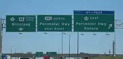
| Winnipeg By-Pass | ||||
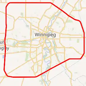
Perimeter Highway highlighted in red. | ||||
| Route information | ||||
| Auxiliary route of PTH 1 | ||||
| Maintained by Manitoba Infrastructure | ||||
| Length | 89.5 km (55.6 mi) | |||
| Existed | 1955–present | |||
| Component highways | ||||
| Major junctions | ||||
| Beltway around Winnipeg, Manitoba | ||||
| East end | ||||
| West end | ||||
| Length | 40 km (20 mi) | |||
| Major junctions | ||||
| Length | 49.5 km (30.8 mi) | |||
| Major junctions | ||||
| Location | ||||
| Rural municipalities | ||||
| Major cities | Winnipeg | |||
| Highway system | ||||
| Manitoba provincial highways Winnipeg City Routes
| ||||
History and Future Plans
The Perimeter Highway is a four-lane divided expressway that consists of a mixture of interchanges and at-grade intersections. It was originally built in 1955 to bypass city centre rush hour traffic. The southern segment of the Perimeter Highway, or South Perimeter, is the Trans-Canada Highway's official Winnipeg Bypass and designated as Highway 100. The northern segment, or North Perimeter is a provincial highway designated as PTH 101. However, PTH 101 is part of Canada's National Highway System while PTH 100 is not. The South Perimeter Highway bridge across the Red River and roadway at Pembina Highway/PTH 75 south was constructed in 1958. The job was tendered to Peter Leitch Construction Ltd. at a cost of $188,670. In December 1957, Dominion Bridge was awarded the contract ($80,157) to supply the structural steel for the overpass.[1]
The Perimeter Highway was originally unconnected between PTH 59 and PTH 15 as PTH 59 had received significant upgrades, making the need for a northeast section less pressing. PTH 59 continued to serve as the de facto northeast leg of the Perimeter until the mid-1990s, when PTH 59 and PTH 15 were connected. The last remaining two-lane section was the PTH 59 north interchange, which was upgraded over a three-year span ending in 2018.[2][3] The highway now encircles Winnipeg as a four-lane roadway.
Improvements were made to the western segment of the highway in the early 2010s when PTH 190, Centreport Canada Way, was constructed. In addition to the interchange that connected to this new highway, a flyover was constructed over Saskatchewan Avenue (PR 425) and the adjacent railway crossing; and the median was closed at the entrance to Assiniboia Downs leaving only right-in/right-out access from the southbound side.
Planning is currently underway to upgrade the South Perimeter to a six-lane freeway.[4] The first execution of this plan included closing multiple medians and minor accesses to the South Perimeter, and replacing others with right-in/right-out accesses.[5] In 2020, the Manitoba government announced that the first major upgrade would be to replace the traffic signals at St. Mary's Road with an interchange, construction for which is planned to begin in 2021 and finish in 2023.[6]
Exit list
Exit numbering begins at Fermor Avenue and increases clockwise.
| Location | km | mi | Exit | Destinations | Notes | |||
|---|---|---|---|---|---|---|---|---|
| Springfield | 0.0 | 0.0 | 1 | Cloverleaf interchange Signed as exits 1A (west) and 1B (east) | ||||
| 0.3 | 0.19 | Railway Crossing | Grade-separated | |||||
| 2.0 | 1.2 | Murdock Road north | Westbound (clockwise) right-in/right-out | |||||
| 3.6 | 2.2 | Symington Road | At grade | |||||
| ↑ / ↓ | 5.2 | 3.2 | Plessis Road | Median closed, right-in/right-out access only | ||||
| Winnipeg | 6.8 | 4.2 | 8 | Partial cloverleaf interchange | ||||
| 7.9 | 4.9 | Melnick Road north Budd Road south | Westbound (clockwise) right-in/right-out Eastbound (counter-clockwise) right-in/right-out | |||||
| 8.0 | 5.0 | Canadian Pacific Railway | Level crossing | |||||
| 8.1 | 5.0 | Aimes Road north Sumka Road south | Westbound (clockwise) right-in/right-out Eastbound (counter-clockwise) right-in/right-out | |||||
| 8.8 | 5.5 | At grade; traffic signals | ||||||
| 12.4 | 7.7 | At grade; traffic signals | ||||||
| 14.0 | 8.7 | Crosses the Red River | ||||||
| 14.1 | 8.8 | Kilkenny Drive/Cloutier Drive | Grade separated; no access | |||||
| 15.9 | 9.9 | 18 | Cloverleaf interchange Signed as exits 18A (north) and 18B (south) | |||||
| 16.2 | 10.1 | Canadian National Railway | Grade-separated | |||||
| 17.2 | 10.7 | Waverley Street south | At grade; traffic signals | |||||
| 17.9 | 11.1 | At grade; traffic signals | ||||||
| ↑ / ↓ | 20.2 | 12.6 | Brady Road | No access, intersection permanently closed | ||||
| Macdonald | 21.4 | 13.3 | At grade; traffic signals | |||||
| 21.9 | 13.6 | Canadian Pacific Railway | Level crossing | |||||
| 23.1 | 14.4 | Municipal Road 9E (La Salle Road) | Median closed, right-in/right-out access only | |||||
| 24.7 | 15.3 | Municipal Road 8E | Median closed, right-in/right-out access only | |||||
| 26.4 | 16.4 | Municipal Road 7E | No access, intersection permanently closed | |||||
| 26.8 | 16.7 | At-grade Eastbound (counter-clockwise) right-in only | ||||||
| 28.0 | 17.4 | At grade; traffic signals | ||||||
| 29.8 | 18.5 | Oakland Road west Township Road 53NE east | Southbound (counter-clockwise) right-in/right-out Nouthbound (clockwise) right-in/right-out | |||||
| 30.2 | 18.8 | Central Manitoba Railway (CEMR) | Level crossing | |||||
| 30.7 | 19.1 | La Verendrye Road west | Southbound (counter-clockwise) right-in/right-out | |||||
| ↑ / ↓ | 31.0 | 19.3 | Two Mile Road | Southbound (counter-clockwise) right-in/right-out | ||||
| Winnipeg | 35.3 | 21.9 | Partial cloverleaf interchange | |||||
| 35.3 | 21.9 | Canadian National Railway | Grade-separated | |||||
| 38.1 | 23.7 | 40 | Partial cloverleaf interchange Signed as exits 40A (east) and 40B (west) counterclockwise | |||||
| 38.6 | 24.0 | Crosses the Assiniboine River | ||||||
| 38.6 | 24.0 | Oxbow Bend Road | Grade separated; no access | |||||
| 39.3 | 24.4 | Oak Forest Crescent Augier Avenue | Southbound (counter-clockwise) right-in/right-out Northbound (clockwise) right-in | |||||
| 40.0 | 24.9 | 42 | Cloverleaf interchange Signed as exits 42A (east) and 42B (west) | |||||
| 40.7 | 25.3 | Service road – Assiniboia Downs | Southbound (counter-clockwise) right-in/right-out | |||||
| 42.0 | 26.1 | Grade separated; no access, intersection permanently closed | ||||||
| 42.0 | 26.1 | Canadian Pacific Railway | Grade-separated | |||||
| 43.1 | 26.8 | 45 | Partial cloverleaf interchange Signed as exits 45A (east) and 45B (west) | |||||
| 44.0 | 27.3 | Boychuk Road | No access, intersection permanently closed | |||||
| Rosser | 45.6 | 28.3 | Selkirk Avenue / Township Road 63N | At grade | ||||
| 47.3 | 29.4 | Inkster Boulevard / Township Road 64N | At grade | |||||
| 48.5 | 30.1 | 50 | Partial cloverleaf interchange | |||||
| 48.5 | 30.1 | Canadian Pacific Railway | Grade-separated | |||||
| 51.2 | 31.8 | Service Road | At grade | |||||
| 51.3 | 31.9 | Canadian National Railway | Level crossing | |||||
| 52.1 | 32.4 | At grade; traffic signals | ||||||
| 52.9 | 32.9 | Summit Road | At grade | |||||
| 54.6 | 33.9 | Sturgeon Road | At grade | |||||
| 56.2 | 34.9 | Klimpke Road | At grade | |||||
| 57.9 | 36.0 | 60 | Cloverleaf interchange Signed as exits 60A (South) and 60B (North) | |||||
| 59.5 | 37.0 | King Edward Street | At grade | |||||
| 59.8 | 37.2 | Canadian Pacific Railway | Level crossing | |||||
| West St. Paul | 62.8 | 39.0 | At grade; traffic signals | |||||
| 65.5 | 40.7 | Second Street south / Holmes Road north | No access, intersection permanently closed | |||||
| 66.8 | 41.5 | 69 | Cloverleaf interchange Signed as exits 69A (south) and 69B (north) | |||||
| 68.7 | 42.7 | Kapelus Drive north Prest Avenue south | Westbound (clockwise) right-in/right-out Eastbound (counter-clockwise) right-in/right-out | |||||
| 69.0 | 42.9 | Canadian Pacific Railway | Level crossing | |||||
| 69.6 | 43.2 | 71 | Cloverleaf interchange Signed as exits 71A (south) and 71B (north) | |||||
| ↑ / ↓ | 70.3 | 43.7 | Crosses the Red River | |||||
| East St. Paul | 70.7 | 43.9 | 72 | Partial cloverleaf interchange | ||||
| 72.1– 74.6 | 44.8– 46.4 | 76 | Interchange[7] Signed as exits 76A (north) and 76B (south) | |||||
| 76.2 | 47.3 | Wenzel Street | At grade | |||||
| ↑ / ↓ | 77.0 | 47.8 | Central Manitoba Railway (CEMR) | Grade separated | ||||
| Springfield |
No major junctions | |||||||
| ↑ / ↓ | 80.2 | 49.8 | Gunn Road | At grade | ||||
| Winnipeg | 83.5 | 51.9 | Canadian National Railway | Level crossing | ||||
| ↑ / ↓ | 83.6 | 51.9 | At grade; traffic signals | |||||
| Springfield | 85.3 | 53.0 | St. Boniface Road | Southbound (counter-clockwise) right-in/right-out | ||||
| 87.0 | 54.1 | Niakwa Road | No access, intersection permanently closed | |||||
| 87.2 | 54.2 | Greater Winnipeg Water District Railway (GWWDRR) | Level crossing | |||||
| 88.6 | 55.1 | Navin Road | No access, intersection permanently closed | |||||
| 89.5 0.0 | 55.6 0.0 | 1 | Cloverleaf interchange Signed as exits 1A (west) and 1B (east) | |||||
1.000 mi = 1.609 km; 1.000 km = 0.621 mi
| ||||||||
Inner city beltway, the second half of the Perimeter plan
This roadway is what was to be part of a two ring road system, with the outer Perimeter Highway, and an inner ring. The inner ring was initially tabled in the 1960s and was slow to progress.
The inner ring, also sometimes referred to as the inner city beltway, was to be (Route 17) the Chief Peguis Trail to the north, heading west to Route 96 (William R. Clement Pkwy), circling to Route 165 (Bishop Grandin Blvd), and from there to a point near Northern Blower on Route 37 (Regent Ave). Several years ago a group working with a councillor, worked to stop the loop from going into the Transcona area, and had the roadway's land designated a natural prairie grass park. From this point on Regent, the road was supposed to loop north back to Route 17 (Chief Peguis Tr). The current plan has had to move the eastern portion to Plessis Road. Plessis Road is not as suited to the required connection and space for intersections, but is the only remaining viable option.
While construction of the east–west Bishop Grandin portion was done years ago, the northern portions have remained unlinked, with only the short portion between Route 52 (Main Street) and Lagimodière. This has provided an effective link over the Red River, but the short span of road leaves much of the north part of the city with difficult navigation choices on an east–west basis, often pushing major cross town traffic to use residential roads and regional arteries like Inkster, MacIvor and Springfield Roads.
The city of Winnipeg completed the extension of Route 17 (Chief Peguis Tr) to Lagimodière Blvd in [8] December 2011. This brings the inner ring road one step further to completion.
The absence of a link between the intersection of Route 52 (Main St) and Route 17 (Chief Peguis Tr) toward Route 90 (Brookside Blvd) makes east-west travel difficult, and is an important link for the north part of town to significant areas like the Airport and Red River Community College, as well as the future CentrePort (an inland port).
The land for these links is owned by the city and simply awaits the laying of roadway. These type of major traffic arteries are designed to carry crosstown traffic efficiently with fewer environmentally damaging starts and stops. Further these roadways are designed to move traffic away from direct contact with residential streets.
References
- "Giant Overpass, Bridge For City Perimeter Route". The Winnipeg Tribune. January 30, 1958.
- Rollason, Kevin. "Work starts on interchange at Perimeter, Highway 59". Retrieved 6 September 2015.
- Lawson, Kim. "Cloverleaf at Perimeter, Hwy 59 Under Construction". AM 680 CJOB. Retrieved 6 September 2015.
- "Province looks for input on plans to change South Perimeter Highway into a freeway". CTV News. December 10, 2019.
- "South Perimeter Highway Safety Plan". Manitoba Government. 2019.
- "Manitoba government plans new interchange for South Perimeter Highway". Global News. June 29, 2020.
- "PTH 59 – PTH 101 Interchange Construction Project" (Map). Government of Manitoba. Retrieved December 15, 2016.
- "Chief Peguis Trail extension opens". CBC News. December 2, 2011.
| Preceded by Highway 1 |
Trans-Canada Highway Highway 100 |
Succeeded by Highway 1 |
| British Columbia | ||
|---|---|---|
| Alberta | ||
| Saskatchewan | ||
| Manitoba | ||
| Ontario | ||
| Quebec | ||
| New Brunswick | ||
| Prince Edward Island | ||
| Nova Scotia | ||
| Newfoundland | ||
| ||