Winnipeg Route 57
Route 57 is a major road located in Winnipeg, Manitoba. It connects the suburbs of St. James and St. Boniface with the West End and the downtown core.
| ||||
|---|---|---|---|---|
| Dublin Avenue Notre Dame Avenue / Cumberland Avenue Carlton Street / Portage Avenue Westbrook Street William Stephenson Way / Pioneer Avenue Provencher Boulevard | ||||
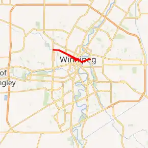
Route 57 highlighted in red | ||||
 Corner of Portage and Main as seen from eastbound Portage Ave (Route 57) | ||||
| Route information | ||||
| Maintained by City of Winnipeg | ||||
| Length | 8.4 km[1] (5.2 mi) | |||
| Existed | 1966–present | |||
| Known for | Junction of Portage and Main | |||
| Major junctions | ||||
| West end | Route 90 (King Edward St) | |||
| East end | Route 30 (Archibald St) | |||
| Highway system | ||||
| Manitoba provincial highways Winnipeg City Routes
| ||||

Route Description
Route 57 begins as Dublin Avenue at Route 90 in the St. James Industrial Area near the Winnipeg airport. It follows Dublin Avenue, then diverts onto eastbound Notre Dame Avenue. Between Sherbrook Street and Portage Avenue, Route 57 follows different streets, Notre Dame Avenue (westbound), Fort Street (northbound), or Cumberland Avenue (eastbound) and Carlton Street (southbound). The westbound route passes through the Exchange District.
East of Portage Avenue, Route 57 passes by Shaw Park and The Forks as it follows Pioneer Avenue (westbound) or William Stephenson Way (eastbound) via Main Street. It crosses the Provencher Bridge into St. Boniface and follows Provencher Boulevard, the main street of Old St. Boniface. It crosses the Seine River before ending at Archibald Street.
History
Dublin Avenue is named after the Irish capital. Notre Dame Avenue (not to be confused with Notre Dame Street in St. Boniface) was named for a girls' school which was located on the road (it later moved to Academy Road). William Stephenson Way (formerly Water Avenue) is named after the British-Canadian spy, who was born in Winnipeg.[2]
Provencher Boulevard is named for Norbert Provencher, the first Roman Catholic Bishop of St. Boniface.[2] Many city heritage buildings, including the former St. Boniface City Hall, are located along this street.[3]
Major intersections
From west to east:
| Street Name | Location | km[1] | mi | Destinations | Notes |
|---|---|---|---|---|---|
| Dublin Avenue | St. James-Assiniboia | 0.0 | 0.0 | Dublin Avenue | Continues west |
| Route 57 western terminus | |||||
| 0.5 | 0.31 | St. James Street | |||
| Notre Dame Avenue | 1.2 | 0.75 | Notre Dame Avenue | Route 57 branches east onto Notre Dame Avenue | |
| Midland Street | Eastbound right-in/right-out | ||||
| Dublin Avenue east end • Notre Dame Avenue west end | |||||
| West End | 1.7 | 1.1 | Weston Street | ||
| 1.75 | 1.09 | Erin Street | One-way, southbound | ||
| 1.9 | 1.2 | Wall Street | One-way northbound (no access, T-intersection) | ||
| 2.6 | 1.6 | ||||
| 2.9 | 1.8 | Arlington Street | |||
| 3.4 | 2.1 | ||||
| Notre Dame Avenue (westbound) Cumberland Avenue (eastbound) | Downtown | 3.6 | 2.2 | One-way, southbound | |
| Cumberland Avenue west end (one-way transition) | |||||
| 3.8 | 2.4 | Sherbrook Street | Route 70 / one-way, northbound south of Notre Dame Avenue | ||
| 4.3 | 2.7 | ||||
| Notre Dame Avenue (westbound) Carlton Street (eastbound) | 4.6 | 2.9 | Carlton Street | Route 57 east branches south onto Carlton Street; one-way, southbound | |
| Cumberland Avenue | One-way, eastbound; direct eastbound access only | ||||
| Cumberland Avenue east end • Carlton Street north end | |||||
| 4.9 | 3.0 | Ellice Avenue | Access from Route 57 eastbound | ||
| Notre Dame Avenue (westbound) Portage Avenue (eastbound) | 5.1 | 3.2 | Carlton Street | Route 57 east branches east onto Portage Avenue (two-way traffic); west end of Route 57 east / Route 85 concurrency | |
| Carlton Street south end • Portage Avenue west end (eastbound) | |||||
| 5.2 | 3.2 | Hargrave Street | One-way, northbound | ||
| 5.3 | 3.3 | One-way, southbound | |||
| 5.4 | 3.4 | One-way, northbound | |||
| 5.5 | 3.4 | Garry Street | One-way, southbound | ||
| Ellice Avenue | Access from Route 57 westbound | ||||
| Portage Avenue | 5.6 | 3.5 | West end of Route 57 west / Route 85 concurrency; one-way northbound (westbound) Route 57 west branches west onto Notre Dame Avenue | ||
| Notre Dame Avenue east end (westbound) | |||||
| 5.7 | 3.5 | See Portage and Main | |||
| Westbrook Street | 6.0 | 3.7 | Westbrook Street – Shaw Park | Route 57 branches south onto Westbrook Street | |
| Portage Avenue east end • Westbrook Street north end | |||||
| Pioneer Avenue (westbound) William Stephenson Way (eastbound) | 6.05– 6.10 | 3.76– 3.79 | One-way westbound; Route 52 west branches north onto Westbrook Street | ||
| William Stephenson Way | One-way eastbound; Route 52 east branches east onto William Stephenson Way | ||||
| Westbrook Street south end • Pioneer Avenue / William Stephenson Way west end (one-way transition) | |||||
| Pioneer Avenue | 6.4 | 4.0 | Waterfront Drive / Israel Asper Way – Canadian Museum for Human Rights, The Forks | ||
| William Stephenson Way east end (one-way transition) | |||||
| Red River | 6.8 | 4.2 | Provencher Bridge Pioneer Avenue east end • Provencher Boulevard west end | ||
| Provencher Boulevard | St. Boniface | 7.0 | 4.3 | Tache Avenue | |
| 7.9 | 4.9 | Thibault Street / Des Meurons Street | |||
| 8.4 | 5.2 | Route 57 eastern terminus | |||
1.000 mi = 1.609 km; 1.000 km = 0.621 mi
| |||||
References
- Google (August 16, 2017). "Route 57 in Winnipeg, Manitoba" (Map). Google Maps. Google. Retrieved August 16, 2017.
- "History in Winnipeg Street Names". Manitoba Historical Society. Retrieved 1 November 2014.
- "St. Boniface City Hall". Manitoba Historical Society. Retrieved 1 November 2014.