Winston Churchill Boulevard
Winston Churchill Boulevard is a long north-south roadway that predominately forms the western boundary of Peel Region with the eastern boundaries of Halton Region and Wellington County, in Ontario, Canada. The road begins at Lakeshore Road in the south at the boundaries of the City of Mississauga the Town of Oakville, and ends in Caledon at East Garafraxa-Caledon Townline. The road is named in honour of British Prime Minister Sir Winston Churchill.
 Adamson Street | |||||||
|---|---|---|---|---|---|---|---|
| Peel Regional Road 19 Wellington County Road 25 | |||||||
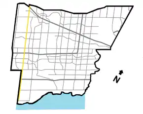 Winston Churchill Blvd. within Mississauga | |||||||
| Route information | |||||||
| Maintained by City of Mississauga Region of Peel Wellington County Town of Caledon Town of Erin Township of East Garafraxa | |||||||
| Length | 60 km (40 mi) | ||||||
| Major junctions | |||||||
| South end | Lakeshore Road | ||||||
| Queen Elizabeth Way Dundas Street Burnhamthorpe Road Eglinton Avenue | |||||||
| North end | |||||||
| Location | |||||||
| Major cities | Mississauga Brampton | ||||||
| Towns | Oakville Milton Halton Hills Caledon Erin | ||||||
| Highway system | |||||||
Roads in Ontario
| |||||||
The road is designated as Peel Regional Road 19 in the two segments where it forms Peel's boundary with the aforementioned divisions:[1]
- In the north, between Beech Grove Sideroad in Caledon and Highway 407 in Brampton/Halton Hills
- In the south, between Dundas Street and Lakeshore Road
Halton Region shares jurisdiction with the Region of Peel over segments of the road along the Halton-Peel boundary between Highway 407 and Mayfield Road and designates it as Halton Regional Road 19,[2] although only Peel Road 19 signs are posted. The Town of Halton Hills shares jurisdiction with the Region of Peel over the segments along the Halton-Peel boundary between Mayfield Road and 32 Sideroad. Wellington County shares jurisdiction with the Region of Peel over the segment between 32 Sideroad and Beech Grove Sideroad, and designates it as Wellington County Road 25. The remaining northerly segment between Beech Grove Sideroad and East Garafaxa-Caledon Townline is under joint jurisdiction between the Town of Caledon, Town of Erin and Township of East Garafraxa, where Winston Churchill forms the boundary between any two of these municipalities. The segment between Highway 407 and Dundas Street is entirely within Peel Region (the region line is shifted west to Highway 407 and 9th Line), and is under the jurisdiction of the City of Mississauga. Formerly, this section also formed the divisional boundary, but was changed due to municipal restructuring in 1974 resulting in transferring of the lands to the west to Mississauga.[3]
In the community of Norval, Winston Churchill Boulevard deviates westward to be situated entirely within Halton Region and is known as Adamson Street. Despite this, it is still signed exclusively as Peel Regional Road 19.
Within Terra Cotta, Winston Churchill deviates eastward to be situated entirely within the Town of Caledon. It is concurrent with Peel Regional Road 9 (King Street) for approximately 550 metres.
Transit
In Mississauga, the road is served by routes 45 and 45A, both of which run from Clarkson GO Station to Meadowvale Town Centre.[4][5] The Mississauga Transtiway's western terminus, Winston Churchill Station is located barely north of Highway 403. In Brampton, there aren't any routes mainly serving the route.[6]
References
- "Map of Peel Regional Roads" (PDF). Peel Region. December 2007. Retrieved 2008-04-26.
- "Archived copy". Archived from the original on 2012-06-20. Retrieved 2012-08-28.CS1 maint: archived copy as title (link)
- "Preserve Our Heritage: Lost Villages". Heritage Mississauga. Mississauga Heritage Foundation. Retrieved August 12, 2020.
- "45 Winston Churchill Map" (PDF). mississauga.ca. City of Mississauga. 27 February 2017. Retrieved 14 February 2020.
- "45A Winston Churchill-Speakman Map" (PDF). mississauga.ca. City of Mississauga. 27 February 2017. Retrieved 14 February 2020.
- "Brampton Transit System Map" (PDF). brampton.ca. City of Brampton. 2019. Retrieved 14 February 2020.
| North-South routes |  Peel Regional Road Shield | |
|---|---|---|
| East-West routes | ||