Wyoming Highway 450
Wyoming Highway 450 (WYO 450) is a 66.22-mile-long (106.57 km) east-west Wyoming State Road in Campbell and Weston counties that provides travel between WYO 59 at Wright and U.S. Route 16 (US 16) at Newcastle.
| ||||
|---|---|---|---|---|
| Little Thunder Road | ||||
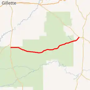
WYO 450 highlighted in red | ||||
| Route information | ||||
| Maintained by WYDOT | ||||
| Length | 66.22 mi[1] (106.57 km) | |||
| Major junctions | ||||
| West end | ||||
| East end | ||||
| Location | ||||
| Counties | Campbell, Weston | |||
| Highway system | ||||
State highways in Wyoming
| ||||

Route description
Wyoming Highway 450 begins its western end in the Town of Wright in Campbell County at Wyoming Highway 59, just south of the eastern terminus of Wyoming Highway 387.[2][3] Highway 450 heads due east through Thunder Basin National Grassland for much of its length. Nearing 21 miles, WYO 450 leaves Campbell County and enters Weston. The southern terminus of Wyoming Highway 116 is intersected at approximately 36.5 miles (58.7 km).[2] Nearing its eastern end WYO 450 reaches the City of Newcastle, the county seat of Weston County, where it ends at US Route 16.
Major intersections
| County | Location | mi | km | Destinations | Notes |
|---|---|---|---|---|---|
| Campbell | Wright | 0.00 | 0.00 | Western terminus of WYO 131 | |
| Weston | | 36.50 | 58.74 | Southern terminus of WYO 116 | |
| Newcastle | 66.22 | 106.57 | Eastern terminus of WYO 450 | ||
| 1.000 mi = 1.609 km; 1.000 km = 0.621 mi | |||||
References
- Wyoming @ AARoads.com - Wyoming Routes 400-499
- Google (28 December 2016). "Overview Map of Wyoming Highway 450" (Map). Google Maps. Google. Retrieved 28 December 2016.
- Wyoming Department of Transportation Reference Marker Book - November 2004 (PDF) (Map). WYDOT. Archived from the original (PDF) on July 17, 2011. Retrieved 2010-07-15.
External links
| Wikimedia Commons has media related to Wyoming Highway 450. |
