Çekerek
Çekerek is a town and district of Yozgat Province in the Central Anatolia region of Turkey. It is located in northeast of Yozgat province and it is 90 km (56 miles) far from there. According to 2019 census, population of the district is 22,863 of which 9,900 live in the town of Çekerek and remaining 12,963 people live in rural areas.
Çekerek | |
|---|---|
District | |
 Location of Çekerek within Turkey. | |
 Çekerek Location of Çekerek within Turkey. | |
| Coordinates: 40°04′N 35°30′E | |
| Country | |
| Province | Yozgat |
| Government | |
| • Mayor | Eyyup Çakır (AKP) |
| Area | |
| • District | 751 km2 (290 sq mi) |
| Elevation | 925 m (3,035 ft) |
| Population | |
| • Urban | 9,900 |
| • District | 22,683 |
| • District density | 30/km2 (78/sq mi) |
| Time zone | UTC+2 (EET) |
| • Summer (DST) | UTC+3 (EEST) |
| Postal code | 66500 |
| Area code(s) | 354 468 XX XX |
| Licence plate | 66 FX XXX |
| Website | www.cekerek.gov.tr |
History
Çekerek was a village called 'Hacıköy', which was a central village and a part of Zile district of Tokat. In 1924–1925, the town center was transferred from Zile to Kadışehri, then Hacıköy was made a villace of it. One year later, the town center was transferred again and Hacıköy became the town center and Kadışehri became a part of it. In 1928, when Sorgun, another district of Yozgat now, became a district, Hacıköy was transferred again to it as a subdistrict and kept this situation until 1944. In 1944, the name of Çekerek River was given to village and Çekerek became a district of Yozgat. In the same year, municipality of Çekerek was established. Kadışehri and Aydıncık which were villages of Sorgun were attached to it. On 20 May 1990, with Law Number 3644, Aydıncık became a district with 32 villages and Kadışehri became a district also with 33 villages which constituted 55 of 105 villages of Çekerek before. This situation affected Çekerek badly. Çekerek has 40 villages and 4 subdistrict now.
Notes
- "Area of regions (including lakes), km²". Regional Statistics Database. Turkish Statistical Institute. 2002. Retrieved 2013-03-05.
- "Population of province/district centers and towns/villages by districts - 2012". Address Based Population Registration System (ABPRS) Database. Turkish Statistical Institute. Retrieved 2013-02-27.
References
- Falling Rain Genomics, Inc. "Geographical information on Çekerek, Turkey". Retrieved 2008-03-20.
External links
- District governor's official website (in Turkish)
- General information on Çekerek (in Turkish)
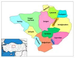
Çekerek in Yozgat Province of Turkey | |||||||||||||||||||||||||||
|---|---|---|---|---|---|---|---|---|---|---|---|---|---|---|---|---|---|---|---|---|---|---|---|---|---|---|---|
| Districts | Districts of Yozgat | ||||||||||||||||||||||||||
| |||||||||||||||||||||||||||
Metropolitan municipalities are bolded. | |||||||||||||||||||||||||||