1930 Bago earthquake
The 1930 Bago earthquake, also known as the Swa earthquake struck Burma on May 5 with a magnitude between 7.3 and 7.5.[1][2] This earthquake was one of the most destructive to hit the country and one of several earthquakes to affect the country between 1929 and 1931. Extensive damage was reported in the southern part of the country, and more than 550 people were killed.
 1930 Bago earthquake (Myanmar) | |
| UTC time | 1930-05-05 13:46:01 |
|---|---|
| ISC event | 907352 |
| USGS-ANSS | ComCat |
| Local date | May 5, 1930 |
| Local time | 20:18:?? Myanmar Standard Time |
| Magnitude | 7.3-7.5 Mw |
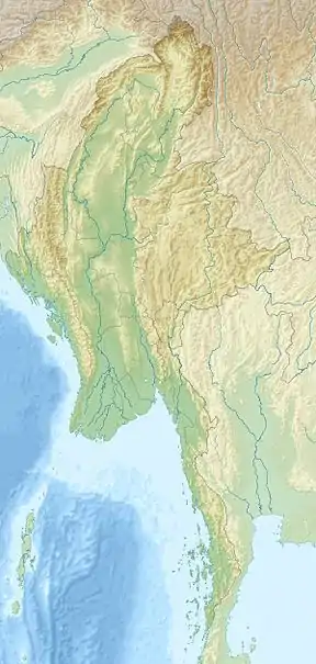
| Epicenter | 17.860°N 96.430°E |
| Fault | Sagaing |
| Type | Strike-slip |
| Areas affected | Myanmar |
| Total damage | Widespread |
| Max. intensity | X (Extermely high intensity tremor) |
| Tsunami | 1.06 m (Local) |
| Casualties | 558 fatalities |
Tectonic setting
The Sagaing Fault is a major continental transform fault that runs through the country and connects the Andaman spreading center to the collision zone in the north. This earthquake ruptured along the Bago segment of the Sagaing fault for a length of 100 km, it extends from the southern coast of Burma to roughly 20 kilometres (12 mi) north of the city of Bago.[3] Its epicenter is located north of Bago, near the Pegu range. It was followed-up with the 1930 Pyu earthquake seven months later. There is a 50 kilometres (31 mi) section of fault between the two rupture zones that did not slip in either event. Maximum offset was measured at 3 metres (9.8 ft).[4]
Earthquake
Damage and casualties
Shaking intensity reached IX to X on the Rossi-Florel scale within a pear-shaped area of 375 square miles (970 km2) along the fault. Shaking was violent enough to destroy most of Pegu. An eyewitness observed surface waves propagating through a tennis court. Fires erupted, causing further destruction in the city, and reports of liquefaction took place shortly after. The death toll is estimated at 500 in Pegu.[5]
In Tawa, seven people were killed, two buildings totally collapsed, pagodas and roads destroyed and subsidence occurred.
At Khayan, there was a partial collapse of a hospital, various buildings, and a mosque. Fissures and vents spewed enough water and to bury parts of the town and cause floods. Between 12 to 16 deaths were from here.
The Sagaing Fault runs under Thongwa, where serious destruction also took place. A railway station platform fissured and abutments of the railway bridge sank and were shifted from their original positions. Similar to other towns, many masonry buildings collapsed or were badly damaged.
In Rangoon, the shock toppled the Shwedagon Pagoda, an important religious landmark in the city.[6] More than 50 major buildings had to be replaced. The confirmed death toll was reported at 58, and 204 were injured from collapsing masonry. The most severe damage was situated in the southern portion of the city which it sits on a river delta where alluvium deposited by the Irrawaddy River.[7] The British Geological Survey building along Dalhousie Road cracked in many areas. The interior of the building which housed a laboratory and museum was wrecked. Along China Street, pucca houses caved inwards and numerous buildings withstood shaking but were uninhabitable.[8]
The shock was powerful enough to be felt in Shan state and the Kingdom of Siam for area size of 220,000 square miles (570,000 km2).[9]
Tsunami
A local tsunami with a run-up height of 1.06 metres (3 ft 6 in) was recorded along the coast.[10] The tsunami travelled up the Sittaung River and flooded several villages along the way.
Related events
The Bago earthquake was one of several destructive earthquakes to occur in Burma from 1929 to 1932.
Aftershocks
Countless aftershocks were reported months after the earthquake. An aftershock on September 16, at 5:30 pm, resulted in the cracking of a brick wall on a police station in Pado.[8]
December 4 earthquake
Seven months after the earthquake at Bago, another earthquake of magnitude 7.3 struck about 48.2 km north, along the Sagaing Fault killing a further 36 people. Slippage along the fault twisted a crossing railroad. Major damage in Pyu, similar to the severity of the May shock was seen.
Images
 Shwemawdaw Pagoda that was destroyed in the Bago earthquake
.jpg.webp) Remnants of the Shwemawdaw Pagoda after the quake.
Remnants of the Shwemawdaw Pagoda after the quake.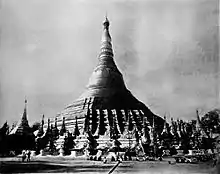 The old Shwedagon Pagoda prior to its destruction photographed in the 1900s
References
- "Event 907352 Myanmar". www.isc.ac.uk. Retrieved 2020-10-14.
- "Significant Earthquakes Full Search, sort by Date, Country". www.ngdc.noaa.gov. Retrieved 2020-10-14.
- Yu, Wang. "Active tectonics and earthquake potential of the Myanmar region". Journal of Geophysical Research: Solid Earth.
- Yu, Wang. "Earthquakes and slip rate of the southern Sagaing fault: insights from an offset ancient fort wall, lower Burma (Myanmar)" (PDF). Geophysical Journal International. 185: 49–64.
- "On This Day | The 1930 Earthquake Which Flattened Bago". The Irrawaddy. 2019-05-05. Retrieved 2020-10-14.
- "May 5, 1930 – the last time Yangon rocked". The Myanmar Times. 2016-12-09. Retrieved 2020-10-14.
- Aung, Hla Hla. "Reinterpretation of historical earthquakes during 1929 to 1931, Myanmar". Solid Earth Science. 31.
- Brown, Coggin. "A PRELIMINARY NOTE ON THE PEGU EARTHQUAKE OF MAY 5TH 1930". Geological Survey of India. LXV.
- "NCEI Global Historical Hazard Database". www.ngdc.noaa.gov. Retrieved 2020-10-14.
- "NCEI Global Historical Hazard Database". www.ngdc.noaa.gov. Retrieved 2020-10-14.
