1932 Atlantic hurricane season
The 1932 Atlantic hurricane season was the period during 1932 in which tropical cyclones formed in the Atlantic Basin. It was a relatively active season, with fifteen known storms, six hurricanes, and four major hurricanes.[nb 1] Two storms attained Category 5 intensity, the first known occurrence in which multiple Category 5 hurricanes formed in the same year. The season began with the formation of Tropical Storm One on May 5, and ended with the dissipation of Hurricane Fourteen, also known as the 1932 Cuba hurricane, on November 14. Tropical cyclones that did not approach populated areas or shipping lanes, especially if they were relatively weak and of short duration, may have remained undetected. Because technologies such as satellite monitoring were not available until the 1960s, historical data on tropical cyclones from this period are often not reliable. The Atlantic hurricane reanalysis project discovered four new tropical cyclones, all of which were tropical storms, that occurred during the year. These storms were later added to the HURDAT database.[2]
| 1932 Atlantic hurricane season | |
|---|---|
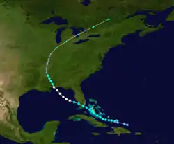
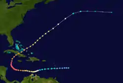
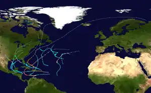 Season summary map | |
| Seasonal boundaries | |
| First system formed | May 5, 1932 |
| Last system dissipated | November 14, 1932 |
| Strongest storm | |
| Name | "Cuba" |
| • Maximum winds | 175 mph (280 km/h) (1-minute sustained) |
| • Lowest pressure | 915 mbar (hPa; 27.02 inHg) |
| Seasonal statistics | |
| Total storms | 15 |
| Hurricanes | 6 |
| Major hurricanes (Cat. 3+) | 4 |
| Total fatalities | ≥3,384 direct, 1 indirect |
| Total damage | $77.706 million (1932 USD) |
| Related article | |
In total, the season resulted in at least 3,384 fatalities and at least $77.706 million in damages.[nb 2] A strong hurricane struck Freeport, Texas in mid–August, severely affecting a large swath of the coast. A Category 5 hurricane, the first of the season, devastated areas of The Bahamas, especially the Abaco Islands. Another strong Category 4 hurricane struck Puerto Rico in late September, leaving catastrophic damage and causing $30 million in damages. A second Category 5 hurricane in early November became one of the deadliest hurricanes of the 20th century after making landfall on Cuba and killing at least 3,103 people. A hurricane and four other tropical storms made landfalls during the season.
Timeline

Systems
Tropical Storm One
| Tropical storm (SSHWS) | |
  | |
| Duration | May 5 – May 10 |
|---|---|
| Peak intensity | 65 mph (100 km/h) (1-min) 995 mbar (hPa) |
A tropical depression formed on May 5 in the south-central Caribbean. Moving slowly northeast, the system became a tropical storm the next day and gradually strengthened before making landfall on Hispaniola with winds of 50 miles per hour (80 km/h) on May 7. The system crossed the Dominican Republic, emerging into the western Atlantic on May 8 as it continued to strengthen, reaching its peak intensity of 65 mph (105 km/h) on May 10 while centered south-southwest of Bermuda. The diffuse system later transitioned into an extratropical storm the same day, later dissipating on May 11 well to the northwest of Bermuda after merging with a frontal boundary.[2][3]
Hurricane Two
| Category 4 hurricane (SSHWS) | |
  | |
| Duration | August 12 – August 15 |
|---|---|
| Peak intensity | 150 mph (240 km/h) (1-min) 935 mbar (hPa) |
The Freeport Hurricane of 1932
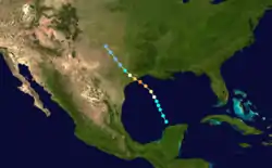
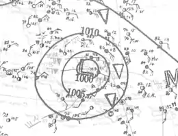
A tropical storm formed on August 11 in the southern Gulf of Mexico near the Yucatán Peninsula. Moving northward over the southern Gulf of Mexico on the 12th, it rapidly intensified as it reached hurricane status, later becoming a Category 4 hurricane with winds estimated at 150 mph (240 km/h) and an estimated central pressure of 935 mb (27.6 inHg) shortly before making landfall near Freeport, Texas, on August 13.[2] The eye of the compact storm crossed the coast about 10 p.m. CDT on August 13, creating a 40–30 mi (64–48 km) wide path of heavy destruction in Brazoria County, Texas. The lowest barometric pressure recorded was 27.83 inches (938 mbar) in Velasco in Brazoria County. Official warning on the storm began just four hours prior to the storm's landfall, and many people evacuating inland were forced to abandon their cars in high winds and heavy rains.[4]
In Galveston, Texas, power to electrical and phone service was cut off, temporarily reducing communications. The passage between Galveston Island and mainland Texas was flooded, temporarily cutting off Galveston from the mainland. Heavy rains occurred, and a foot of rain fell as the storm moved north towards the coast.[4][5] 40 people were killed by the hurricane. The greatest single death toll for any town was seven in West Columbia, Texas, where sustained winds over 100 mph (160 km/h) flattened several homes. Two neighborhoods that had been constructed for oil industry workers there were nearly destroyed by the high tides and storm surge. Freeport, Angleton and Galveston suffered extensive wind damage, and the inland towns of Brazoria, West Columbia, Damon and Needville, all in the path of the eye, were also devastated. Damages associated with the hurricane were estimated to total to $7.5 million.[4]
Hurricane Three
| Category 1 hurricane (SSHWS) | |
  | |
| Duration | August 26 – September 2 |
|---|---|
| Peak intensity | 85 mph (140 km/h) (1-min) 979 mbar (hPa) |
A tropical disturbance was first identified north of Hispaniola on August 26. Slowly moving towards the west-northwest, it intensified to tropical storm strength before making landfall on South Florida early on August 30. After crossing the Florida peninsula and entering the Gulf of Mexico, the system reached its peak intensity as a Category 1 hurricane with winds of 85 mph (137 km/h), before subsequently making its final landfall near the Mississippi–Alabama border on September 1 at peak intensity.[3] Over land, the hurricane weakened, and after becoming an extratropical cyclone on September 2, the storm merged with another extratropical system over Quebec on September 4.[2]
At the storm's initial landfall in southern Florida, heavy rains and strong winds caused extensive damage to crops, particularly to avocado and citrus. As the strengthening hurricane moved northwestwards through the Gulf of Mexico, it generated strong surf that caused severe damage to coastal areas across western Florida,[2][6] before making its second landfall, where it produced hurricane force winds across a wide swath of the coast.[2] Agricultural lands in coastal regions of Mississippi and Alabama were damaged by strong winds and heavy rain.[2] The hurricane caused one indirect death and $226,000 in total damages across its path.
Hurricane Four
| Category 5 hurricane (SSHWS) | |
  | |
| Duration | August 30 – September 9 |
|---|---|
| Peak intensity | 160 mph (260 km/h) (1-min) ≤ 921 mbar (hPa) |
The Great Bahamas Hurricane of 1932 or Hurricane San Ciprián of 1932
A tropical depression was first detected north of the Virgin Islands late on August 30. Moving towards the west-northwest, the depression steadily intensified, reaching tropical storm strength and later hurricane strength on September 2, as it passed near the Turks and Caicos Islands.[3] After reaching hurricane intensity, the hurricane began to rapidly intensify,[7] becoming a major hurricane on September 4. The intensifying hurricane moved through The Bahamas and reached its peak intensity as a Category 5 hurricane, the first of the season, with maximum sustained winds of 160 mph (260 km/h). Afterwards, the hurricane slowly weakened as it recurved towards the north and subsequently northeast, bypassing New England before becoming extratropical on September 9. The extratropical cyclone traversed across Iceland and later dissipated on September 17.[3]
The hurricane caused extensive devastation across much of The Bahamas, where it killed 16 people and injured an additional 300 people.[7] Strong winds destroyed numerous homes and hampered water and food supplies. The large hurricane also generated a strong storm surge which inundated the Abaco Islands.[8] Effects of the hurricane in the United States were much less severe, due to the distance of the hurricane. However, strong gales still swept through much of New England.[7]
Tropical Storm Five
| Tropical storm (SSHWS) | |
  | |
| Duration | September 4 – September 7 |
|---|---|
| Peak intensity | 70 mph (110 km/h) (1-min) 992 mbar (hPa) |
On September 4, an area of low pressure developed from a stationary front over the open Atlantic Ocean. At the time, a warm front and cold front were connected to the system, but further observations revealed minimal temperature deviations. The following day, the disturbance appeared to have acquired subtropical characteristics, but became tropical after observations showed that winds associated with the storm were near the center. The storm later weakened and was absorbed by a frontal boundary at 1800 UTC on September 7.[2]
Tropical Storm Six
| Tropical storm (SSHWS) | |
  | |
| Duration | September 9 – September 15 |
|---|---|
| Peak intensity | 60 mph (95 km/h) (1-min) 999 mbar (hPa) |
A tropical storm first formed in the Bay of Campeche on September 9.[3] Moving slowly northwards,[9] the tropical storm reached its peak intensity of 60 mph (97 km/h) while located south of the Mississippi River Delta.[3] Beginning on September 14, the storm began to accelerate as it turned towards the northeast,[9] and subsequently made landfall at peak intensity near St. Marks in the Big Bend region of Florida at 0400 UTC on September 15. The storm crossed the peninsula in only six hours, before becoming extratropical at 12000 UTC later that day.[2] The extratropical cyclone quickly accelerated parallel to the United States East Coast, before being absorbed by another extratropical system over Quebec.[3] Due to the tropical storm's quick passage over the Florida peninsula, damage was relatively minor.[2] A train crossed over a washout on its railroad, causing it to derail.[10] In Apalachicola, there was considerable damage to crops, and torrential rains caused $2,000 in damages.[2] Electric power in the city was also disabled, and some buildings suffered structural damage, totaling to $8,000 in damages.[11]
Tropical Storm Seven
| Tropical storm (SSHWS) | |
  | |
| Duration | September 16 – September 23 |
|---|---|
| Peak intensity | 65 mph (100 km/h) (1-min) 994 mbar (hPa) |
On September 16, a tropical storm with winds of 40 mph (64 km/h) developed out of a frontal boundary in the central North Atlantic.[2][3] Moving slowly towards the northwest,[3] gales were reported by ships in the region as the tropical storm slowly intensified.[2] On September 20, the storm began to move towards the southwest. The system reached peak intensity on September 21, with winds of 65 mph (105 km/h), before transitioning into an extratropical cyclone as it recurved northwards on September 23.[2][3] The extratropical cyclone later made landfall on Nova Scotia the following day, before dissipating over Greenland on September 26.[2]
Tropical Storm Eight
| Tropical storm (SSHWS) | |
  | |
| Duration | September 18 – September 20 |
|---|---|
| Peak intensity | 65 mph (100 km/h) (1-min) 998 mbar (hPa) |
Another tropical depression was first identified on September 18 in the Bay of Campeche. Moving quickly towards the north-northeast, the depression intensified to a tropical storm and reached peak intensity with maximum sustained winds of 65 mph (105 km/h) and a minimum pressure of 998 mbar (29.5 inHg) early the next day.[3] The storm subsequently made landfall near Morgan City, Louisiana at 1900 UTC on September 19.[2] Weakening over land, the tropical storm degenerated to a tropical depression at 1200 UTC on September 20, before becoming extratropical the next day west of Louisville, Kentucky and later dissipating after it was absorbed by an approaching front.[2][3]
Since the storm made landfall in a sparsely populated region of Louisiana, only minimal damage was reported. Prior to the storm's landfall, however, hedge selling of cotton were offset in late dealings caused by fears of the storm's potential impact.[12] A tornado was reported in West Baton Rouge Parish, blowing down sugarcane along a path 8 mi (13 km) long.[11] Further inland, heavy rains associated with the system were reported, peaking at 3.01 in (76 mm) in Vicksburg, Mississippi.[2]
Hurricane Nine
| Category 4 hurricane (SSHWS) | |
  | |
| Duration | September 25 – October 2 |
|---|---|
| Peak intensity | 145 mph (230 km/h) (1-min) 943 mbar (hPa) |
Hurricane San Ciprián of 1932
On September 25, ships first noted a tropical storm east of the Leeward Islands. The tropical storm quickly intensified as it moved towards the west due to a nearby high pressure system, reaching hurricane strength at 0600 UTC that day. As it approached Puerto Rico, the hurricane continued to rapidly intensify, before reaching its peak intensity as a Category 4 hurricane with winds of 145 mph (233 km/h) and a minimum pressure of 943 mbar (27.8 inHg) on September 27, before making landfall near Ceiba, Puerto Rico at 0300 UTC.[2][9] The hurricane slightly weakened over the island, and after crossing the Mona Passage, made a second landfall in southern areas of the Dominican Republic as a Category 2 hurricane. Its passage of Hispaniola significantly weakened the hurricane, downgrading it to tropical strength. After brushing Jamaica to the south, the tropical storm struggled to organize, and did not strengthen up until landfall on British Honduras with winds of 45 mph (72 km/h) and an estimated minimum pressure of 1,003 mbar (29.6 inHg) October 1.[3] There, the storm quickly weakened, and dissipated over southeastern Mexico on October 3.[2]
The hurricane was considered the worst to affect Puerto Rico since the 1928 Okeechobee hurricane.[13] Strong storm surge and winds devastated areas of the island coast.[9] Winds also knocked out communications systems, hampering relief efforts.[14] Additional rainfall also inundated numerous homes.[15] In Puerto Rico, the hurricane killed 257 people, and caused $30 million in damages.[16]
Tropical Storm Ten
| Tropical storm (SSHWS) | |
  | |
| Duration | September 28 – September 30 |
|---|---|
| Peak intensity | 45 mph (75 km/h) (1-min) 1004 mbar (hPa) |
A tropical storm was first identified in the eastern Atlantic on September 28 as a small, compact system,[2] with winds of 40 mph (64 km/h) and a minimum pressure of 1,004 mbar (29.6 inHg). Moving slowly towards the southeast, the storm was able to slightly intensify to a peak intensity of 45 mph (72 km/h),[3] before interacting with an extratropical cyclone which pulled it to the northwest, which absorbed the system at 0600 UTC on September 30.[2][3]
Tropical Storm Eleven
| Tropical storm (SSHWS) | |
  | |
| Duration | October 7 – October 15 |
|---|---|
| Peak intensity | 70 mph (110 km/h) (1-min) 990 mbar (hPa) |
A tropical depression first formed on October 7 from a broad low-pressure area in the central Caribbean Sea northeast of Honduras.[2][3] Moving slowly to the west-northwest,[17] the depression steadily intensified, reaching tropical storm strength at 1200 UTC the same day. The storm continued to intensify as it moved towards the Yucatán Peninsula, reaching peak intensity late on October 9, with maximum sustained wind speeds of 70 mph (110 km/h).[3] The storm made landfall near Playa del Carmen at 0400 UTC the next day, while still at peak intensity.[2] Over land, the storm degenerated into a tropical depression on October 11 as it began to curve towards the north. The depression later reentered the Gulf of Mexico the following, where it began to restrengthen. By 1200 UTC on October 13, the elongated system regained tropical storm strength, before reaching a secondary peak intensity of 60 mph (97 km/h).[3] However, baroclinic forces caused the storm to become extratropical prior to making landfall on the Louisiana coast in the afternoon of October 15. The extratropical remnants of the storm continued to trek to the northeast, before it merged with another extratropical system.[2]
The approaching storm forced storm warnings to be issued for several areas of the Gulf Coast from Brownsville, Texas to Apalachicola, Florida. Its extratropical remnants brought gale–force winds to portions of Louisiana.[17] Offshore, a cargo ship carrying asphalt sunk due to strong waves, causing $30,000 in losses.[18] In addition heavy rains caused rivers to exceed flood stage, particularly east of where the storm made landfall,[5] isolating homes and interrupting traffic. Black Warrior River exceeded its flood stage by 14 ft (4.3 m), and the Catawba River also overflowed.[19] A peak rainfall of 8.5 in (220 mm) was reported during a 17‑hour period in Tuscaloosa, Alabama. The storm also brought widespread rainfall across the South Atlantic States through orographic lift, peaking at 9.3 in (240 mm) in Rock House, North Carolina.[5] Washout from the rains also caused a train wreck.[19]
Tropical Storm Twelve
| Tropical storm (SSHWS) | |
  | |
| Duration | October 8 – October 12 |
|---|---|
| Peak intensity | 60 mph (95 km/h) (1-min) 997 mbar (hPa) |
A tropical depression was first identified on October 8 northeast of the Virgin Islands and quickly intensified to a tropical storm. Moving towards the west and then northwest, the storm intensified to its peak intensity of 60 mph (97 km/h) at 1800 UTC on October 10 as it neared Bermuda.[3] The lowest pressure recorded in Bermuda was 1,002 mbar (29.6 inHg), which was associated with minimal tropical storm force winds.[2] The storm weakened as it progressed further northwards and curved towards the northeast, before transitioning into an extratropical cyclone by 0600 UTC on October 12.[3] The system was absorbed by a strong cold frontal boundary later that day.[2]
Tropical Storm Thirteen
| Tropical storm (SSHWS) | |
  | |
| Duration | October 18 – October 21 |
|---|---|
| Peak intensity | 70 mph (110 km/h) (1-min) 999 mbar (hPa) |
On October 17, a stationary front positioned over the eastern Atlantic began to dissipate, and a large area of low pressure began to form along the front boundary. The disturbance intensified to tropical storm strength at 0000 UTC on October 18, after losing baroclinity. As it moved towards the north,[3] the system slowly intensified to an estimated peak intensity of 70 mph (110 km/h) at 0600 UTC on October 19, as suggested by a nearby ship that also reported 70 mph (110 km/h) winds.[2] At the same time, the tropical storm also began to curve more towards the east, and subsequently began to weaken. The system degenerated to tropical depression strength on October 21, and shortly after dissipated.[3]
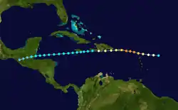
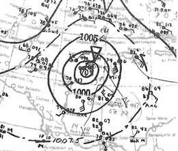
Hurricane Fourteen
| Category 5 hurricane (SSHWS) | |
  | |
| Duration | October 30 – November 14 |
|---|---|
| Peak intensity | 175 mph (280 km/h) (1-min) ≤ 915 mbar (hPa) |
The Great Cuba Hurricane of 1932
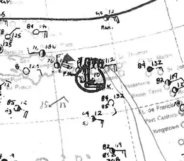
A tropical storm formed on October 30 in the Atlantic Ocean east of the Virgin Islands. It steadily intensified, and the system was upgraded to hurricane strength on November 1 as it headed southwest into the Caribbean. It was upgraded to Category 2 status on November 3 with winds of 100 mph (160 km/h). The storm strengthened into a major hurricane on November 4, and continued to intensify, peaking as an intense Category 5 hurricane with a central pressure at or below 915 mb (27.02 inHg) on November 5 in the western Caribbean. The storm later weakened, and struck central Cuba on November 9 with winds of 150 mph (240 km/h) and a central pressure of 918 mb (27.11 inHg), later weakening to a Category 3 hurricane after crossing the island.[2] The storm continued to slowly weaken as it moved through the Bahamas the following day, later weakening to a tropical storm and becoming an extratropical storm the next day over the central North Atlantic. The storm caused severe damage and a total of 3,033 deaths in Cuba.[20][21]
Hurricane Fifteen
| Category 2 hurricane (SSHWS) | |
  | |
| Duration | November 3 – November 10 |
|---|---|
| Peak intensity | 100 mph (155 km/h) (1-min) 973 mbar (hPa) |
A tropical storm was first identified in the Central Atlantic at 0600 UTC on November 3,[3] with ships reporting moderate gales in its vicinity. Throughout its existence, the storm moved in an erratic path, generally to the north.[22] Steadily intensifying, the tropical storm attained hurricane strength at 1800 UTC on November 6, as it began to move towards the northeast towards the Azores. The hurricane continued to intensify, attaining Category 2 intensity on November 8 and at the same time reaching its peak intensity with winds of 100 mph (160 km/h). After reaching peak intensity, a weakening trend began as the storm accelerated towards the northeast. Early on November 10, it transitioned into an extratropical cyclone, while still maintaining winds of hurricane force.[3] The extratropical system continued to quickly move towards the northeast, until it coalesced with another extratropical cyclone on November 11.[22]
Season effects
The following table lists all of the storms that formed in the 1932 Atlantic hurricane season. It includes their duration, names, areas affected, damages, and death totals. Deaths in parentheses are indirect (an example of an indirect death would be a traffic accident), but were still related to that storm. Damage and deaths include totals from the storm's precursor and its remnants, and all of the damage figures are in 1932 USD.
| Saffir–Simpson scale | ||||||
| TD | TS | C1 | C2 | C3 | C4 | C5 |
| Storm name |
Dates active | Storm category
at peak intensity |
Max 1-min wind mph (km/h) |
Min. press. (mbar) |
Areas affected | Damage (USD) |
Deaths | Refs | ||
|---|---|---|---|---|---|---|---|---|---|---|
| One | May 5–10 | Tropical storm | 65 (100) | 995 | Hispaniola | None | None | |||
| Two | August 12–15 | Category 4 hurricane | 150 (240) | 935 | Texas | $7.5 million | 40 | |||
| Three | August 26 – September 2 | Category 1 hurricane | 85 (140) | 979 | Turks and Caicos Islands, The Bahamas, Southeastern United States, Midwest United States, Ontario, Quebec | $226 thousand | (1) | |||
| Four | August 30 – September 9 | Category 5 hurricane | 160 (260) | ≤921 | The Bahamas, Southeastern United States, United States East Coast, Newfoundland, Greenland, Iceland, Jan Mayen Island, Scandinavia, Soviet Union | Unknown | 16 | |||
| Five | September 4–7 | Tropical storm | 70 (110) | 992 | None | None | None | |||
| Six | September 9–15 | Tropical storm | 60 (95) | 999 | Florida | $20 thousand | None | |||
| Seven | September 16–22 | Tropical storm | 65 (100) | 994 | Nova Scotia | Unknown | None | |||
| Eight | September 18–20 | Tropical storm | 65 (100) | 998 | West South Central United States (Louisiana), Ohio River Valley | Unknown | None | |||
| Nine | September 25 – October 2 | Category 4 hurricane | 145 (230) | 943 | Leeward Islands (Virgin Islands), Greater Antilles (Puerto Rico, Hispaniola, Jamaica), Belize, Mexico | $30 million | >225 | |||
| Ten | September 28–30 | Tropical storm | 45 (75) | 1004 | None | None | None | |||
| Eleven | October 7–15 | Tropical storm | 70 (110) | 990 | Belize, Mexico, Southeastern United States, Ohio River Valley | Unknown | None | |||
| Twelve | October 8–12 | Tropical storm | 60 (95) | 997 | Bermuda | Unknown | None | |||
| Thirteen | October 18–21 | Tropical storm | 70 (110) | 999 | None | None | None | |||
| Fourteen | October 30 – November 14 | Category 5 hurricane | 175 (280) | ≤915 | Leeward Islands, Venezuela, Colombia, Jamaica, Cayman Islands, Cuba, The Bahamas, Bermuda | $40 million | >3,103 | |||
| Fifteen | November 3–10 | Category 2 hurricane | 100 (155) | 973 | Azores | Unknown | None | |||
| Season aggregates | ||||||||||
| 15 systems | May 5 – November 10 | 175 (280) | ≤915 | $77.706 million | >3,384 (1) | |||||
See also
- List of tropical cyclones
- List of Atlantic hurricanes
- Atlantic hurricane season
Notes
- A major hurricane is a storm that ranks as Category 3 or higher on the Saffir–Simpson hurricane scale.[1]
- All damage totals are in 1932 United States dollars unless otherwise noted.
References
- Chris Landsea (June 2, 2011). "A: Basic Definitions". In Neal Dorst (ed.). Hurricane Research Division: Frequently Asked Questions. Atlantic Oceanographic and Meteorological Laboratory. A3) What is a super-typhoon? What is a major hurricane ? What is an intense hurricane ?. Retrieved January 4, 2013.
- National Hurricane Center (April 2012). "Atlantic hurricane best track (HURDAT) Meta Data, 1932 Meta Data". United States National Oceanic and Atmospheric Administration's Office of Oceanic & Atmospheric Research. Retrieved November 7, 2012.
- National Oceanic and Atmospheric Administration. "NOAA HURDAT Data". Retrieved January 5, 2012.
- David Roth (January 17, 2010). "Texas Hurricane History: Early 20th century" (PDF). Hydrometeorological Prediction Center. pp. 40–41. Retrieved May 8, 2012.
- Schoner, R.W.; Molansky, S. "Rainfall Associated With Hurricanes (And Other Tropical Disturbances)" (PDF). United States Weather Bureau's National Hurricane Research Project. Retrieved January 6, 2013.
- "Tropical Disturbance is Moving With Force Being Greatly Diminished Today". Times Daily. Mobile, Alabama. Associated Press. September 1, 1932. p. 1. Retrieved January 5, 2013.
- Mitchell, Charles L. (September 1932). "The Tropical Storm of August 30-September 15, 1932" (PDF). Monthly Weather Review. 60 (9): 177–178. Bibcode:1932MWRv...60..177.. doi:10.1175/1520-0493(1932)60<177:TTSOAI>2.0.CO;2.
- "Hurricane Reports Received From Abaco Show 11 Dead, Many Hurt". Palm Beach Post. Associated Press. September 10, 1932. pp. 1, 6.
- "West Indian Hurricanes of August and September, 1932". Monthly Weather Review. 60 (9): 177–179. September 1, 1932. Bibcode:1932MWRv...60..177.. doi:10.1175/1520-0493(1932)60<177:TTSOAI>2.0.CO;2.
- "Georgia, Florida Struck By Gale". Spokane Daily Chronicle. Apalachicola, Florida. Associated Press. September 15, 1932. p. 1. Retrieved January 6, 2013.
- "SEVERE LOCAL STORMS, SEPTEMBER, 1932" (PDF). Monthly Weather Review. 60 (9): 191–192. September 1, 1932. Bibcode:1932MWRv...60..191.. doi:10.1175/1520-0493(1932)60<191:SLSS>2.0.CO;2. Retrieved January 5, 2013.
- "Cotton Prices Rise After Wide Range". New York Times. September 20, 1932. Retrieved January 13, 2013.
- "San Juan is Hit By Hurricane; 30 Lives Lost, Damage Great". The Southeast Missourian. San Juan, Puerto Rico. Associated Press. September 27, 1932. p. 1. Retrieved January 12, 2013.
- Beverly, James R. (September 30, 1932). "Hurricane Deaths Reach 204 and Injuries 2,000; Puerto Rico Chief Estimates $35,000,000 Loss". The Pittsburgh Press. San Juan, Puerto Rico. p. 17. Retrieved January 12, 2013.
- "Storm-Swept Puerto Rico Asks For Relief". Berkeley Daily Gazette. Washington, D.C. United Press. September 28, 1932. p. 1. Retrieved January 12, 2013.
- James R. Beverley (1933). "Thirty-Third Annual Report of the Governor of Puerto Rico 1933". Archived from the original on July 7, 2001. Retrieved April 17, 2007.
- Weightman, R. H. (October 1, 1932). "Tropical Disturbance of October 7 to 15, 1932" (PDF). Monthly Weather Review. 60 (10): 193. Bibcode:1932MWRv...60..193W. doi:10.1175/1520-0493(1932)60<193c:TDOOT>2.0.CO;2.
- "Severe Local Storms, October 1932" (PDF). Monthly Weather Review. 60 (10): 206. October 1, 1932. Bibcode:1932MWRv...60..206.. doi:10.1175/1520-0493(1932)60<206:SLSO>2.0.CO;2. Retrieved January 11, 2013.
- "Floods Threaten 3 States in the South". The New York Times. Atlanta. Associated Press. October 17, 1932. Retrieved January 11, 2013.
- Paper by Colorado State Univ.
- National Oceanic and Atmospheric Administration. "None". Archived from the original on October 13, 2006. Retrieved October 6, 2006.
- Hurd, Willis E. (November 1, 1932). "North Atlantic Ocean, November, 1932" (PDF). Monthly Weather Review. 60 (11): 227–228. Bibcode:1932MWRv...60..227H. doi:10.1175/1520-0493(1932)60<227:NAON>2.0.CO;2. Retrieved January 12, 2013.
External links
| Wikimedia Commons has media related to 1932 Atlantic hurricane season. |