1997 Central Texas tornado outbreak
A deadly tornado outbreak occurred in Central Texas during the afternoon hours of May 27, 1997 in conjunction with a southwestward moving storm complex. The complex produced 20 total tornadoes, mainly along the Interstate 35 corridor from northeast of Waco to north of San Antonio. The outbreak was particularly noteworthy for spawning the Jarrell tornado, one of the fiercest and most destructive F5 tornadoes ever recorded.
 | |
| Type | Tornado outbreak |
|---|---|
| Duration | May 27, 1997 |
| Tornadoes confirmed | 20 confirmed |
| Max. rating1 | F5 tornado |
| Duration of tornado outbreak2 | 7 hours, 2 minutes |
| Highest winds |
|
| Largest hail | 4.50 in (114 mm) (in Bell and Falls counties) |
| Damage | >$126.6 million (1997 USD) |
| Casualties | 28 fatalities, 32 injuries |
| Areas affected | Central Texas |
| 1Most severe tornado damage; see Fujita scale 2Time from first tornado to last tornado | |
At its peak, the Jarrell tornado was three quarters of a mile (1.2 km) wide and tracked across the ground for 5.1 miles (8.2 km), inflicting catastrophic damage in northwestern parts of Jarrell while killing 27 people.[1][2] All 27 deaths caused by the tornado occurred within one subdivision of Jarrell – a neighborhood of 38 well-built houses called Double Creek Estates. Each residence was completely dismantled, swept away, and reduced to a concrete slab, while trees in the area were completely shredded and debarked, and grassy fields were scoured to a depth of 18 inches (46 cm).[2] Many tornado researchers, after reviewing aerial damage photographs of Double Creek Estates, considered the Jarrell storm to be the most violent tornado they had ever seen in terms of damage intensity.[3]
In addition to the Jarrell tornado, the outbreak produced an F4 tornado near Lake Travis and three F3 tornadoes – including one which moved through Cedar Park.
Meteorological synopsis
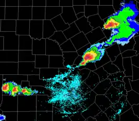
In the early morning hours of May 27, a large mesoscale convective complex developed over eastern Oklahoma and western Arkansas. A "gravity wave" or outflow boundary was generated by this system and stalled out over Central Texas. This was oriented from the northeast to the southwest, causing the supercells and subsequent tornadoes to move from the northeast toward the southwest, which is exceptionally unusual. Also unusual on this day was the low wind shear and extreme atmospheric instability.[2]
Confirmed tornadoes
| FU | F0 | F1 | F2 | F3 | F4 | F5 | Total |
|---|---|---|---|---|---|---|---|
| 0 | 6 | 6 | 3 | 3 | 1 | 1 | 20 |
| F# | Location | County | Start Coord. | Time (UTC) | Path length | Max width | Damage[nb 2] | Summary |
|---|---|---|---|---|---|---|---|---|
| F2 | W of Lorena | McLennan | 31.38°N 97.32°W | 1821 – 1833 | 2 mi (3.2 km) | 75 yd (69 m) | $75,000 | Several large trees were uprooted and a mobile home was destroyed.[4] |
| F0 | Eddy area | McLennan | 31.30°N 97.25°W | 1844 – 1847 | 0.2 mi (0.32 km) | 40 yd (37 m) | N/A | Tornado reported by sheriff deputy caused no damage.[5] |
| F3 | E of Moody | McLennan, Bell | 31.27°N 97.35°W | 1846 – 1859 | 3.7 mi (6.0 km) | 150 yd (140 m) | $150,000 | A home and a barn were destroyed after the tornado initially touched down in open terrain. Two vehicles were also displaced by several hundred feet, and numerous trees were uprooted.[6][7] |
| F0 | WNW of Belton | Bell | 31.08°N 97.53°W | 1916 – 1927 | 0.2 mi (0.32 km) | 50 yd (46 m) | N/A | Weak tornado remained stationary for much of its existence before dissipating.[8] |
| F3 | N of Belton | Bell | 31.17°N 97.47°W | 1927 – 1945 | 1.4 mi (2.3 km) | 275 yd (251 m) | $900,000 | A marina was destroyed on the northern shores of Lake Belton, with over 100 boats capsizing. Ten homes along the same shore sustained severe damage, and a number of trees were destroyed.[9] |
| F1 | SW of Belton | Bell | 31.02°N 97.53°W | 1950 – 1958 | 0.2 mi (0.32 km) | 40 yd (37 m) | N/A | Brief tornado with unknown damage.[10] |
| F1 | Blooming Grove area | Navarro | 32.10°N 96.72°W | 2005 – 2010 | 0.5 mi (0.80 km) | 50 yd (46 m) | N/A | Brief tornado uprooted several large trees.[11] |
| F1 | NW of Prairie Dell | Bell | 30.90°N 97.58°W | 2007 – 2025 | 2.4 mi (3.9 km) | 100 yd (91 m) | $20,000 | Initially stationary tornado that began to quickly track towards the south-southwest, destroying trees and damage several structures.[12] |
| F2 | N of Jarrell | Williamson | 30.8848°N 97.594°W | 2025 – 2033 | 2 mi (3.2 km) | 200 yd (180 m) | N/A | First of two tornadoes that preceded the Jarrell F5 tornado.[13] |
| F2 | NW of Jarrell | Williamson | 30.868°N 97.603°W | 2035 – 2039 | 0.5 mi (0.80 km) | 150 yd (140 m) | N/A | Second of two tornadoes that preceded the Jarrell F5 tornado; classified as a multi-vortex tornado.[14] |
| F1 | S of Dawson | Navarro | 31.87°N 96.72°W | 2036 – 2040 | 0.5 mi (0.80 km) | 50 yd (46 m) | N/A | Brief tornado uprooted large trees.[15] |
| F5 | W of Jarrell | Williamson | 30.84°N 97.618°W | 2040 – 2053 | 5.1 mi (8.2 km) | 1,320 yd (1,210 m) | $40.1 million | 27 deaths – See section on this tornado – 12 others were injured.[16] |
| F0 | SW of Hubbard | Hill | 31.82°N 96.83°W | 2050 – 2053 | 0.2 mi (0.32 km) | 40 yd (37 m) | N/A | Brief tornado caused no damage.[17] |
| F3 | Cedar Park | Williamson, Travis | 30.55°N 97.82°W | 2105 – 2115 | 9.2 mi (14.8 km) | 200 yd (180 m) | $70.11 million | This tornado moved south through Cedar Park before crossing into Travis County and lifting just northeast of Mansfield Dam. A historic train was struck, with a 65,000-pound (29,000 kg) coal tender converted to hold diesel fuel being flipped over and thrown a short distance. The north wall of an Albertsons grocery store was pushed inward slightly, along with large metal doors. Another grocery store had much of its roof torn off, and several other businesses sustained varying degrees of roof and structural damage. Over 100 homes were either damaged or destroyed, with some sustaining significant roof loss and severe structural damage. A pickup truck was tossed into the front wall of one house. Many trees were downed along the path, especially in Travis County. Fifteen people were injured in Cedar Park.[18][19] |
| F1 | NW of Four Points | Travis | 30.40°N 97.85°W | 2115 – 2115 | 0.2 mi (0.32 km) | 20 yd (18 m) | $5,000 | Brief tornado with minimal damage.[20] |
| F4 | W of Lakeway | Travis | 30.37°N 98.02°W | 2150 – ? | 5.6 mi (9.0 km) | 440 yd (400 m) | $15 million | 1 death – The tornado touched down near the shore of Lake Travis, destroying a marina and most of the watercraft at the docks. Numerous structures sustained varying degrees of damage as the tornado moved westward and later southwestward, including a Southwest Bell telephone building that was destroyed and a home across the road which had several collapsed walls. The telephone building was well constructed, which warranted an F4 rating. Further southwest, a steel tower carrying high transmission power lines was destroyed. More site-built homes, mobile homes, and other buildings were either heavily damaged or completely destroyed, leaving many uninhabitable. Many trees were downed along the path. Five people were injured.[21] |
| F1 | N of Kyle | Hays | 30.02°N 97.87°W | 2238 – 2245 | 3.5 mi (5.6 km) | 60 yd (55 m) | $5,000 | Trees and power lines were knocked over.[22] |
| F0 | S of Utopia | Uvalde | 29.52°N 99.53°W | 0000 – 0003 | 0.2 mi (0.32 km) | 20 yd (18 m) | N/A | Tornado remained over open country.[23] |
| F0 | NW of Sisterdale | Kendall | 29.98°N 98.75°W | 0030 – 0032 | 0.7 mi (1.1 km) | 30 yd (27 m) | N/A | Tornado remained over open country.[24] |
| F0 | NE of Moore | Frio | 29.07°N 99.00°W | 0120 – 0123 | 1 mi (1.6 km) | 40 yd (37 m) | N/A | Tornado remained over open country.[25] |
Jarrell, Texas
| F5 tornado | |
|---|---|
 View of the Jarrell tornado as it moved near the Double Creek Estates area. | |
| Duration | 13 minutes |
| Max. rating1 | F5 tornado |
| Highest winds |
|
| Casualties | 27 fatalities, 12 injuries |
| 1Most severe tornado damage; see Fujita scale | |
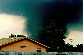
The Jarrell tornado originally touched down at 3:40 p.m. CDT (2040 UTC) as a rope-like tornado near the Bell-Williamson County line. By 3:45 p.m. (2045 UTC), the tornado had quickly intensified into a violent 1⁄2-to-3⁄4-mile (0.80 to 1.21 km) wide multiple-vortex tornado. It scoured a cotton field down to a depth of 18 inches (46 cm) as it moved along a highly unusual southwestwardly path toward the west side of Jarrell.[16]
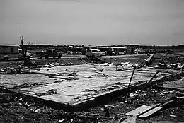
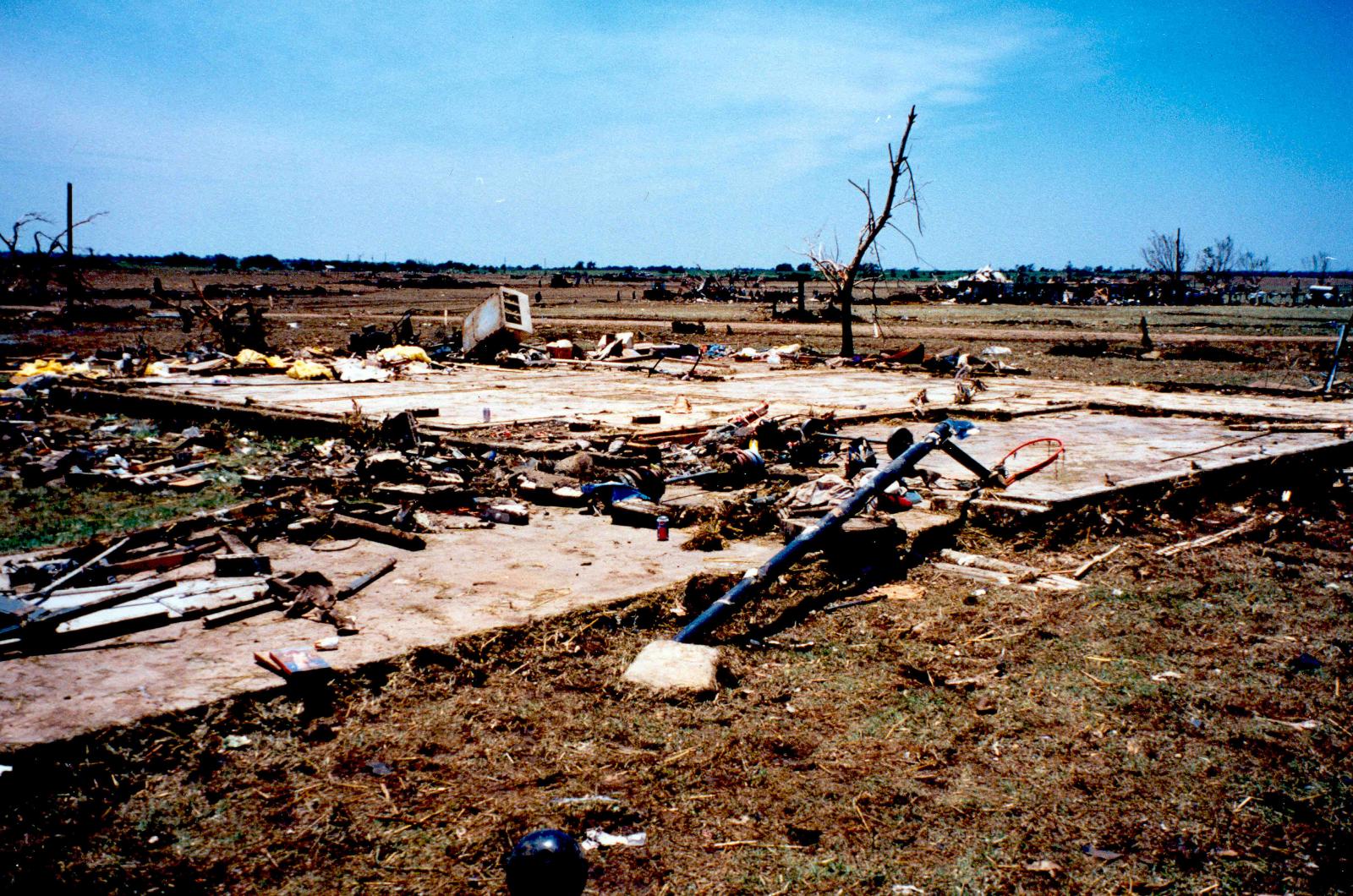
Moving very slowly as a large wedge tornado, the tornado entered the northwestern outskirts of Jarrell at around 3:48 pm CDT and struck the Double Creek Estates neighborhood. Catastrophic damage occurred here, with the tornado completely destroying all 38 houses and killing 27 people in the subdivision. Many of the homes in the tornado's path were well-constructed and bolted to their foundations, but the tornado left only slab foundations and virtually no debris. The debris from the destroyed homes was either thrown several miles away or granulated into small fragments and scattered for long distances across the countryside.[27] The tornado produced some of the most extreme ground scouring ever documented, as the earth at and around the Double Creek Estates was scoured out to depths of 18-24 inches (46-61 cm), reducing lush fields of grass to vast expanses of mud. Numerous vehicles were mangled beyond recognition and caked in mud, others were torn into pieces and scattered across fields, and some were simply never recovered. A recycling plant located near the subdivision was completely obliterated as well, with only the foundation and some twisted metal support beams recovered at the site. As the extremely violent and slow-moving tornado crossed county roads in the area, it tore away 500-foot (152 m) segments of asphalt from the roadways and scattered the fragments downwind. Trees along the path were shredded and completely debarked, one of which was found with an electrical cord impaled through it. [2] Several entire families living in homes at the Double Creek Estates were killed in the tornado, including all five members of the Igo family and all four members of the Moehring family.[28] The tornado victims sustained such extreme physical trauma that recovery teams had difficulty distinguishing human remains from animal remains scattered throughout the area. Many of the human remains were never recovered at all.[29] Additionally, about 300 cattle were killed by the storm.[16] In addition to the 27 deaths in Double Creek Estates, one person was seriously injured and less than a dozen people suffered minor injuries after the tornado.[30]
Past the Double Creek Estates subdivision, the tornado moved further southwest into a heavily wooded area of cedar trees before rapidly dissipating at 3:53 p.m. CDT (2053 UTC), just to the southwest of Jarrell. The tornado lasted 13 minutes, travelling only 5.1 miles (8.2 km) during its lifespan.[16]
The damage caused by the Jarrell tornado is considered by many to have been potentially the most extreme ever documented, though it was noted that the very slow forward movement of the tornado may have exacerbated the severity of the destruction to some extent. The tornado also picked up large amounts of loose soil as it deeply scoured the ground, producing a sandblasting effect on nearby houses and their occupants. However, it was also noted that video of the tornado shows extremely violent rotation and updraft winds comparable to other known extremely violent tornadoes, and that other previously documented slow-moving tornadoes did not produce the extreme level of damage noted in Jarrell. An F5 rating was applied as a result.[31]
A later assessment from NOAA noted:
"In the Double Creek area, approximately 40 structures were totally destroyed. One of the most striking signs in approaching this area was the distinct lack of debris of any size. Closer inspection showed much little debris, but no sign of large items. At least half a dozen cars were identified from the air lying in the open areas, most of them flattened and encrusted with mud and grass. Later, a ground survey revealed that most of the debris that was left in the area was extremely small, indicating the power of the tornadic winds."[26]
There were 27 fatalities, all in the Double Creek Estates neighborhood. Today, the neighborhood has been rebuilt, and Jarrell Memorial Park was constructed on the site of the Igo family home to honor the victims.[32]
Overpass traffic jam
Numerous vehicles sought shelter underneath various overpasses as the Jarrell tornado formed and strengthened, turning Interstate 35 into a virtual parking lot. Texas Highway Patrol worsened the traffic jam by stopping both northbound and southbound traffic in anticipation of the tornado moving southeastward and crossing the highway. The tornado moved parallel to Interstate 35 for nearly its entire lifespan in a south-southwestward direction, a very rare occurrence.
In popular culture
The events and survivor accounts of the tornado were profiled in television documentaries such as the seventh episode of the Discovery Channel program Storm Warning, produced by GRB Entertainment,[33] and the 2006 documentary Ultimate Disaster (also known as Mega Disaster) on National Geographic Channel.[34]
See also
Notes
- All dates are based on the local time zone where the tornado touched down; however, all times are in Coordinated Universal Time for consistency.
- All damage totals are in 2014 USD unless otherwise stated.
References
- May 27, 1997 Severe Weather Event - National Weather Service Forecast Office - WFO, Austin/San Antonio, Texas
- http://www.nws.noaa.gov/om/assessments/pdfs/jarrell.pdf
- National Climatic Data Center. "Storm Event Report for Tornado West of Lorena, Texas". NCDC Storm Events Database. United States National Oceanic and Atmospheric Administration. Retrieved February 25, 2014.
- National Climatic Data Center. "Storm Event Report for Tornado Near Eddy, Texas". NCDC Storm Events Database. United States National Oceanic and Atmospheric Administration. Retrieved February 25, 2014.
- National Climatic Data Center. "Storm Event Report for Tornado East of Moody, Texas". NCDC Storm Events Database. United States National Oceanic and Atmospheric Administration. Retrieved February 25, 2014.
- National Climatic Data Center. "Storm Event Report for Tornado Northwest of Troy, Texas". NCDC Storm Events Database. United States National Oceanic and Atmospheric Administration. Retrieved February 25, 2014.
- National Climatic Data Center. "Storm Event Report for Tornado West-Northwest of Belton, Texas". NCDC Storm Events Database. United States National Oceanic and Atmospheric Administration. Retrieved February 25, 2014.
- National Climatic Data Center. "Storm Event Report for Tornado North of Belton, Texas". NCDC Storm Events Database. United States National Oceanic and Atmospheric Administration. Retrieved February 25, 2014.
- National Climatic Data Center. "Storm Event Report for Tornado Southwest of Belton, Texas". NCDC Storm Events Database. United States National Oceanic and Atmospheric Administration. Retrieved February 25, 2014.
- National Climatic Data Center. "Storm Event Report for Tornado Near Blooming Grove, Texas". NCDC Storm Events Database. United States National Oceanic and Atmospheric Administration. Retrieved February 25, 2014.
- National Climatic Data Center. "Storm Event Report for Tornado Northwest of Prairie Dell, Texas". NCDC Storm Events Database. United States National Oceanic and Atmospheric Administration. Retrieved February 25, 2014.
- National Climatic Data Center. "Storm Event Report for Tornado North of Jarrell, Texas". NCDC Storm Events Database. United States National Oceanic and Atmospheric Administration. Retrieved February 25, 2014.
- National Climatic Data Center. "Storm Event Report for Tornado Northwest of Jarrell, Texas". NCDC Storm Events Database. United States National Oceanic and Atmospheric Administration. Retrieved February 25, 2014.
- National Climatic Data Center. "Storm Event Report for Tornado South of Dawson, Texas". NCDC Storm Events Database. United States National Oceanic and Atmospheric Administration. Retrieved February 25, 2014.
- National Climatic Data Center. "Storm Event Report for Tornado West of Jarrell, Texas". NCDC Storm Events Database. United States National Oceanic and Atmospheric Administration. Retrieved February 25, 2014.
- National Climatic Data Center. "Storm Event Report for Tornado Southwest of Hubbbard, Texas". NCDC Storm Events Database. United States National Oceanic and Atmospheric Administration. Retrieved February 26, 2014.
- National Climatic Data Center. "Storm Event Report for Tornado North of Cedar Park, Texas". NCDC Storm Events Database. United States National Oceanic and Atmospheric Administration. Retrieved February 26, 2014.
- National Climatic Data Center. "Storm Event Report for Tornado Northwest of Four Points, Texas". NCDC Storm Events Database. United States National Oceanic and Atmospheric Administration. Retrieved February 26, 2014.
- National Climatic Data Center. "Storm Event Report for Tornado Northwest of Four Points, Texas". NCDC Storm Events Database. United States National Oceanic and Atmospheric Administration. Retrieved February 26, 2014.
- National Climatic Data Center. "Storm Event Report for Tornado West of Lakeway, Texas". NCDC Storm Events Database. United States National Oceanic and Atmospheric Administration. Retrieved February 26, 2014.
- National Climatic Data Center. "Storm Event Report for Tornado North of Kyle, Texas". NCDC Storm Events Database. United States National Oceanic and Atmospheric Administration. Retrieved February 26, 2014.
- National Climatic Data Center. "Storm Event Report for Tornado South of Utopia, Texas". NCDC Storm Events Database. United States National Oceanic and Atmospheric Administration. Retrieved February 26, 2014.
- National Climatic Data Center. "Storm Event Report for Tornado Northwest of Sisterdale, Texas". NCDC Storm Events Database. United States National Oceanic and Atmospheric Administration. Retrieved February 26, 2014.
- National Climatic Data Center. "Storm Event Report for Tornado Northeast of Moore, Texas". NCDC Storm Events Database. United States National Oceanic and Atmospheric Administration. Retrieved February 26, 2014.
- https://www.weather.gov/media/publications/assessments/jarrell.pdf
- Jarrell, Texas Tornado Damage - May 27, 1997
- https://web.archive.org/web/20170416125715/https://www.statesman.com/news/local/memories-town-and-its-tornado/cOYzIaxQ03XQRGTVHx36rO/
- https://spectrumlocalnews.com/tx/austin/news/2017/05/25/residents-remember-destruction-of-jarrell-tornado
- Storm Warning - Episode 7 - Jarrell, Texas Twister/Ice Queen/Brazil Flood. GRB Entertainment. 1997. Retrieved January 8, 2021 – via YouTube.
- Mega Disaster: Tornado. Natural History New Zealand/National Geographic Channel. 2006. Retrieved January 8, 2021 – via YouTube.
External links
- National Weather Service Assessment (PDF)
- Summary of Weather Event of May 27, 1997 (NWS)
- Aerial Damage Survey of the Central Texas Tornadoes of May 27, 1997 (PDF) (National Weather Service), includes discussion and map of the tornado's track
- Texas Tornadoes (National Climatic Data Center)
- Satellite imagery (University of Wisconsin–Madison)
- Storm chaser Lon Curtis's chase log of the event
- Highway Overpasses as Tornado Shelters: Fallout from the 3 May 1999 Oklahoma/Kansas Violent Tornado Outbreak
- "Jarrell" Reprise: A Fresh Look at the Unusual Central Texas Tornado Outbreak of May 27, 1997 by Lon Curtis and Alan R. Moller
- May 27, 1997 — The Jarrell, Texas Tornado (Shawn Schuman)
- Stormtrack Magazine Nov/Dec 1997: Jarrell, Texas Tornado Expanded Edition (PDF)
- The May 27th 1997 Tornado Outbreak: The 20th Anniversary (NWS Austin/San Antonio)
- Jarrell Tornado 20th Anniversary (NWS Fort Worth)