Hill County, Texas
Hill County is a county in the U.S. state of Texas. As of the 2010 census, its population was 35,089.[1] Its county seat is Hillsboro.[2] The county is named for George Washington Hill, secretary of war and secretary of the navy under the Republic of Texas. Hill County is part of Central Texas, though not included in Texas Hill Country.
Hill County | |
|---|---|
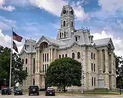 Hill County Courthouse in downtown Hillsboro | |
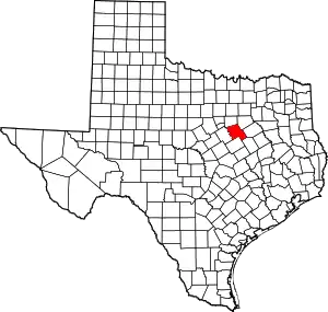 Location within the U.S. state of Texas | |
 Texas's location within the U.S. | |
| Coordinates: 31°59′N 97°08′W | |
| Country | |
| State | |
| Founded | 1853 |
| Named for | George Washington Hill |
| Seat | Hillsboro |
| Largest city | Hillsboro |
| Area | |
| • Total | 986 sq mi (2,550 km2) |
| • Land | 959 sq mi (2,480 km2) |
| • Water | 27 sq mi (70 km2) 2.7%% |
| Population (2010) | |
| • Total | 35,089 |
| • Density | 37/sq mi (14/km2) |
| Time zone | UTC−6 (Central) |
| • Summer (DST) | UTC−5 (CDT) |
| Congressional district | 25th |
| Website | www |
Geography
According to the U.S. Census Bureau, the county has a total area of 986 square miles (2,550 km2), of which 959 square miles (2,480 km2) are land and 27 square miles (70 km2) (2.7%) are covered by water.[3]
Major highways
.svg.png.webp) Interstate 35
Interstate 35
 U.S. Highway 77
 State Highway 22
 State Highway 31
 State Highway 81
 State Highway 171
 State Highway 174
Adjacent counties
- Johnson County (north)
- Ellis County (northeast)
- Navarro County (east)
- Limestone County (southeast)
- McLennan County (south)
- Bosque County (west)
Demographics
| Historical population | |||
|---|---|---|---|
| Census | Pop. | %± | |
| 1860 | 3,653 | — | |
| 1870 | 7,453 | 104.0% | |
| 1880 | 16,554 | 122.1% | |
| 1890 | 27,583 | 66.6% | |
| 1900 | 41,355 | 49.9% | |
| 1910 | 46,760 | 13.1% | |
| 1920 | 43,332 | −7.3% | |
| 1930 | 43,036 | −0.7% | |
| 1940 | 38,355 | −10.9% | |
| 1950 | 31,282 | −18.4% | |
| 1960 | 23,650 | −24.4% | |
| 1970 | 22,596 | −4.5% | |
| 1980 | 25,024 | 10.7% | |
| 1990 | 27,146 | 8.5% | |
| 2000 | 32,321 | 19.1% | |
| 2010 | 35,089 | 8.6% | |
| 2019 (est.) | 36,649 | [4] | 4.4% |
| U.S. Decennial Census[5] 1850–2010[6] 2010–2014[1] | |||
As of the census[7] of 2000, 32,321 people, 12,204 households, and 8,725 families were residing in the county. The population density was 34 people/sq mi (13/km2). The 14,624 housing units averaged 15/sq mi (6/km2). The racial makeup of the county was 84.16% White, 7.40% African American, 0.44% Native American, 0.25% Asian, 6.04% from other races, and 1.71% from two or more races. About 13.49% of the population were Hispanics or Latinos of any race.
Of the 12,204 households, 30.70% had children under 18 living with them, 57.50% were married couples living together, 10.10% had a female householder with no husband present, and 28.50% were not families. About 24.80% of all households were made up of individuals, and 12.50% had someone living alone who was 65 or older. The average household size was 2.58, and the average family size was 3.07.
A Williams Institute analysis of 2010 census data found about 3.2 same-sex couples per 1,000 households were in the county.[8]
In the county, the age distribution was 25.90% under 18, 8.50% from 18 to 24, 24.90% from 25 to 44, 23.40% from 45 to 64, and 17.30% who were 65 or older. The median age was 38 years. For every 100 females there were 96.70 males. For every 100 females age 18 and over, there were 93.70 males.
The median income for a household in the county was $31,600, and for a family was $37,791. Males had a median income of $29,438 versus $20,765 for females. The per capita income for the county was $15,514. About 11.90% of families and 15.70% of the population were below the poverty line, including 19.70% of those under age 18 and 14.60% of those age 65 or over.
Media
Serving Hill County exclusively are media outlets KHBR Radio - 1560 AM and The Reporter newspaper. Hill County is currently listed as part of the Dallas-Fort Worth DMA. Local media outlets include: KDFW-TV, KXAS-TV, WFAA-TV, KTVT-TV, KERA-TV, KTXA-TV, KDFI-TV, KDAF-TV, and KFWD-TV, although it is located in Central Texas and a neighboring county of the Waco metropolitan area. All of the Waco/Temple/Killeen market stations also provide coverage for Hill County. They include: KCEN-TV, KWTX-TV, KXXV-TV, KDYW, and KWKT-TV. Northland Cable Television continues to offer all of the above stations in Hillsboro.
Communities
Politics
Hill County, like most of the rural South, is currently overwhelmingly Republican. The last Democrat to carry Hill County was Bill Clinton in 1992. Before this, like most of Texas, Hill County was solidly Democratic: up to 1979, the county had voted Republican only against Catholic Al Smith in 1928 and against the extremely liberal George McGovern in 1972.
| Year | Republican | Democratic | Third parties |
|---|---|---|---|
| 2020 | 79.9% 11,926 | 19.2% 2,860 | 1.0% 145 |
| 2016 | 77.9% 10,108 | 19.6% 2,547 | 2.4% 315 |
| 2012 | 75.8% 9,132 | 22.9% 2,752 | 1.3% 161 |
| 2008 | 70.3% 9,264 | 28.9% 3,811 | 0.9% 113 |
| 2004 | 70.7% 9,225 | 28.7% 3,751 | 0.6% 77 |
| 2000 | 65.7% 7,054 | 32.8% 3,524 | 1.5% 157 |
| 1996 | 46.5% 4,401 | 42.1% 3,988 | 11.5% 1,084 |
| 1992 | 35.4% 3,669 | 37.9% 3,929 | 26.8% 2,778 |
| 1988 | 52.1% 4,796 | 47.6% 4,381 | 0.2% 21 |
| 1984 | 60.8% 5,344 | 38.9% 3,420 | 0.3% 26 |
| 1980 | 46.0% 4,113 | 52.5% 4,688 | 1.5% 135 |
| 1976 | 33.4% 2,680 | 66.3% 5,327 | 0.3% 25 |
| 1972 | 70.3% 4,481 | 29.5% 1,882 | 0.3% 16 |
| 1968 | 25.9% 1,809 | 49.0% 3,415 | 25.1% 1,753 |
| 1964 | 23.3% 1,557 | 76.6% 5,130 | 0.1% 9 |
| 1960 | 33.8% 2,226 | 65.8% 4,340 | 0.4% 27 |
| 1956 | 37.1% 2,487 | 62.6% 4,199 | 0.3% 21 |
| 1952 | 41.9% 3,242 | 58.1% 4,504 | 0.0% 1 |
| 1948 | 12.2% 657 | 80.9% 4,362 | 7.0% 376 |
| 1944 | 8.6% 516 | 81.5% 4,876 | 9.9% 592 |
| 1940 | 9.5% 627 | 90.5% 6,002 | |
| 1936 | 5.3% 265 | 94.6% 4,710 | 0.1% 5 |
| 1932 | 6.4% 360 | 93.6% 5,297 | 0.1% 5 |
| 1928 | 50.3% 2,446 | 49.7% 2,413 | |
| 1924 | 12.1% 807 | 86.4% 5,778 | 1.5% 103 |
| 1920 | 19.8% 1,022 | 63.1% 3,254 | 17.1% 879 |
| 1916 | 8.6% 382 | 89.1% 3,951 | 2.3% 103 |
| 1912 | 4.2% 129 | 86.7% 2,674 | 9.1% 280 |
See also
References
- "State & County QuickFacts". United States Census Bureau. Archived from the original on October 18, 2011. Retrieved December 17, 2013.
- "Find a County". National Association of Counties. Archived from the original on May 31, 2011. Retrieved 2011-06-07.
- "2010 Census Gazetteer Files". United States Census Bureau. August 22, 2012. Retrieved April 30, 2015.
- "Population and Housing Unit Estimates". United States Census Bureau. May 24, 2020. Retrieved May 27, 2020.
- "U.S. Decennial Census". United States Census Bureau. Retrieved April 30, 2015.
- "Texas Almanac: Population History of Counties from 1850–2010" (PDF). Texas Almanac. Retrieved April 30, 2015.
- "U.S. Census website". United States Census Bureau. Retrieved 2011-05-14.
- Leonhardt, David; Quealy, Kevin (June 26, 2015), "Where Same-Sex Couples Live", The New York Times, retrieved July 6, 2015
- Leip, David. "Dave Leip's Atlas of U.S. Presidential Elections". uselectionatlas.org. Retrieved 9 April 2018.
External links
- Hill County government's website
- Hill County from the Handbook of Texas Online
Places adjacent to Hill County, Texas | ||||||||||
|---|---|---|---|---|---|---|---|---|---|---|
| ||||||||||
Municipalities and communities of Hill County, Texas, United States | ||
|---|---|---|
| Cities | Hill County map | |
| Towns | ||
| Unincorporated communities | ||
| ||

| Authority control |
|---|