Ak-Suu (Syr Darya)
The Ak-Suu (Kyrgyz: Ак-Суу) is a left tributary of the Syr Darya, flowing through Batken Province of Kyrgyzstan and Sughd Province of Tajikistan. The river is formed at the north slopes of Turkestan Range. It flows into the river Syr Darya near the town Nau in northern Tajikistan. The main settlements on the river are the village Ak-Suu in Kyrgyzstan and the town Nau in Tajikistan.
| Ak-Suu | |
|---|---|
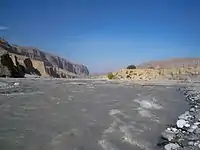 The Ak-Suu near the village of Choyunchu (formerly called Jenish), Leilek District, Kyrgyzstan. | |
| Location | |
| Country | Kyrgyzstan, Tajikistan |
| Physical characteristics | |
| Source | |
| • location | Turkestan Range |
| Mouth | |
• location | Syr Darya |
• coordinates | 40.1933°N 69.3424°E |
| Length | 93 km (58 mi) |
| Basin size | 1,170 km2 (450 sq mi) |
| Discharge | |
| • average | 3.81 m3/s (135 cu ft/s) |
| Basin features | |
| Progression | Syr Darya→ North Aral Sea |
It is 93 kilometres (58 mi) long, and has a drainage basin of 1,170 square kilometres (450 sq mi). Its average flow rate is 3.81 m3/s (135 cu ft/s).[1][2]
References
- "Кыргызстандын Географиясы" [Geography of Kyrgyzstan] (PDF) (in Kyrgyz). Bishkek. 2004. p. 180. Archived from the original (PDF) on 14 July 2014.
- Ошская область: Энциклопедия [Osh Oblast Encyclopedia] (in Russian). Frunze: Chief Editorial Board of Kyrgyz Soviet Encyclopedia. 1994. p. 445.
| Wikimedia Commons has media related to Ak-Suu River. |
This article is issued from Wikipedia. The text is licensed under Creative Commons - Attribution - Sharealike. Additional terms may apply for the media files.
