Naryn (river)
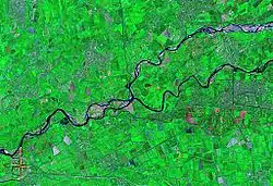
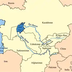
The Naryn (Kyrgyz: Нарын, Russian: Нарын, Uzbek: Norin) rises in the Tian Shan mountains in Kyrgyzstan, Central Asia, flowing west through the Fergana Valley into Uzbekistan. Here it merges with the Kara Darya (near Namangan) to form the Syr Darya. It is 807 kilometres (501 mi) long (together with its upper course Chong-Naryn) and its basin area is 59,100 square kilometres (22,800 sq mi).[1] It has an annual flow of 13.7 cubic kilometres (11,100,000 acre⋅ft).
| Naryn | |
|---|---|
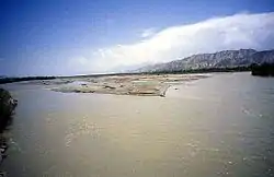 The river Naryn near the town of Naryn | |
| Native name | Нарын дарыясы |
| Location | |
| Country | Kyrgyzstan, Uzbekistan |
| Region | Naryn Region, Jalal-Abad Region |
| Cities | Naryn Karaköl Tashkömür, Uchqo'rg'on |
| Physical characteristics | |
| Source | |
| • location | Naryn Region, Kyrgyzstan |
| Mouth | Syr Darya |
• location | near Namangan, Uzbekistan |
• coordinates | 40°54′3″N 71°45′27″E |
• elevation | 410 m (1,350 ft) |
| Length | 807 km (501 mi) |
| Basin size | 59,100 km2 (22,800 sq mi) |
| Discharge | |
| • location | near mouth |
| • average | 429 m3/s (15,100 cu ft/s) |
| Basin features | |
| Progression | Syr Darya→ North Aral Sea |
| Tributaries | |
| • left | At-Bashy, Ala-Buga |
| • right | On-Archa, Kökömeren, Kara-Suu |
The river contains many reservoirs which are important in the generation of hydroelectricity. The largest of these is the Toktogul Reservoir in Kyrgyzstan containing 19.9 cubic kilometres (16,100,000 acre⋅ft) of water. Dams downstream of the Toktogul in Kyrgyzstan include: Kurpsai, Tash-Kumyr, Shamaldysai and Uch-Kurgansk. Upstream of Toktogul in Kyrgyzstan is the Kambarata-2 and At-Bashi Dams while the Kambarata-1 and Kambarata-3 are in planning stages.[2]
Some places along the river: Kyrgyzstan: Kara-Say (see Barskoon), Naryn Region, Naryn, Dostuk, Jalal-Abad Region, Kazarman, Toktogul Reservoir, Kara-Köl, Tash-Kumyr.
Tributaries
The main tributaries of the Naryn are, from source to mouth:[3]
See also
References
- Нарын (река), Great Soviet Encyclopedia
- "List of major hydroelectric facilities Kyrgyzskoy Republic" (PDF) (in Russian). CA Water. Retrieved 24 February 2012.
- Characteristics of the Rivers of Naryn River Basin (in Russian)
External links