Ar-Ramtha
Ar-Ramtha (Arabic: الرَّمثا, romanized: ar-Ramṯā), colloquially transliterated as ar-Romtha (Arabic: الرُّمثا, romanized: ar-Rumṯā), is a city situated in the far northwest of Jordan near the border with Syria. It covers 40km2 in a flat location 30 km northeast of the Jordan River and Irbid. In the 2017, ar-Ramtha had a population of approximately 164,211, making it the eleventh largest city in Jordan, and the second in Irbid Governorate, and the city has grown since then.[2] It is part of the Ar-Ramthā district of the Irbid Governorate.[3][4]
Ar-Ramtha
مدينة الرمثا | |
|---|---|
City | |
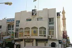 The City Hall | |
 Ar-Ramtha | |
| Coordinates: 32°33′32″N 36°0′53″E | |
| Grid position | 245/218 |
| Country | Jordan |
| Province | Irbid Governorate |
| Municipality established | 1927 |
| Government | |
| • Type | Municipality |
| • Mayor | Hussein Abu Ashshih |
| Elevation | 502 m (1,647 ft) |
| Population (2015)[1] | |
| • Total | 155,693 |
| Time zone | GMT +2 |
| • Summer (DST) | +3 |
| Area code(s) | +(962)2 |
| Website | http://www.ramthacity.gov.jo |
Etymology
Ar-Ramtha is named after a local desert plant, al-ramath (Arabic: الرمثا). During its occupation by the Roman Empire and Byzantine Empire, the city was known as Ramatha.
History
Prehistory
The stable climate in ar-Ramtha and its surrounding areas attracted many animals to live in neighborhood of ar-Ramtha, as well the simple conditions for managing a stable long life there attracted humans to make those regions their earliest choices to gather in groups of hunters and to live in rocky caves. Artifacts and graves in the area show that ar-Ramtha has been inhabited since the Bronze Age (even earlier), but the lack of study of the region gives us no exact information about when humans had selected the land for living.
Roman era
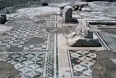
The Roman Empire utilized ar-Ramtha as a remote hub to cross-link their colonies. The ruins of buildings and ancient Roman antiquities have been discovered at different parts of ar-Ramtha. During the Islamic expansion, ar-Ramtha, which was in the Hauran territory, was a port for Muslim scholars crossing between Syria and the Hejaz. Historically and sociologically, the city is the twin to Daraa city in Syria, which is located on just the other side of the border.
Ottoman era
In 1596 it appeared in the Ottoman tax registers under the name of Ramta, being part of the nahiya of Butayna in the Qadaa Hauran. It had an entirely Muslim population consisting of 16 households and 3 bachelors. They paid a fixed tax-rate of 40% on agricultural products, including wheat, barley, summer crops, goats and bee-hives; a total of 2,740 akçe. Half of this was waqf income.[5]
Modern era
The Jordanian census of 1961 found 10,791 inhabitants in Ramtha.[6]
Biblical references
During the battle of Ramoth Gilead between Israel and Arameans, Ahab of Israel joined Jehoshaphat in the battle but was mortally wounded by an arrow and died (1 Kings 22:1–36). Later in an incident occurred when Ahaziah and Joram fought against Hazael, king of Syria and Joram was wounded (2 Kings 8:28). In this city, Jehu, the son of Jehoshaphat, was anointed by one of the sons of the prophets (9:1, 4).
Geography
North west of ar-Ramtha is the second largest source of shale oil in Jordan,[7] which if it is used in producing oil, can enhance economics in Jordan significantly.
Climate
Ar-Ramtha experiences a Mediterranean climate (Csa~Dsa), it has four wonderful seasons with huge variety of life's colors. The summer is hot and long (four months in average), but it has cool nights. Temperatures range in summer from 27 °C (81 °F) – 33 °C (91 °F). Spring and fall temperatures are ideal for a human's body, they range from 17 °C (63 °F) – 23 °C (73 °F). The winter sees nighttime temperatures sometimes below0 °C (32 °F), with snowfall once or twice a year. The yearly average number of days with rain is 77. The lowest temperature ever recorded in Romtha was −18 °C in the blizzard of 1992.
| Climate data for Romtha/Irbid (1982–2008) | |||||||||||||
|---|---|---|---|---|---|---|---|---|---|---|---|---|---|
| Month | Jan | Feb | Mar | Apr | May | Jun | Jul | Aug | Sep | Oct | Nov | Dec | Year |
| Record high °C (°F) | 12.3 (54.1) |
13.8 (56.8) |
23.2 (73.8) |
25.6 (78.1) |
25.7 (78.3) |
30.4 (86.7) |
33.4 (92.1) |
36.1 (97.0) |
32.5 (90.5) |
26.9 (80.4) |
18.2 (64.8) |
12.7 (54.9) |
36.1 (97.0) |
| Average high °C (°F) | 3.0 (37.4) |
5.9 (42.6) |
12.0 (53.6) |
18.7 (65.7) |
23.6 (74.5) |
25.5 (77.9) |
27.7 (81.9) |
32.3 (90.1) |
26.1 (79.0) |
20.5 (68.9) |
13.6 (56.5) |
7.2 (45.0) |
18.0 (64.4) |
| Average low °C (°F) | −4.9 (23.2) |
−2.5 (27.5) |
2.3 (36.1) |
8.8 (47.8) |
9.4 (48.9) |
14.6 (58.3) |
19.7 (67.5) |
18.4 (65.1) |
14.8 (58.6) |
8.5 (47.3) |
5.3 (41.5) |
0.5 (32.9) |
7.9 (46.2) |
| Record low °C (°F) | −20.7 (−5.3) |
−4.6 (23.7) |
0.2 (32.4) |
3.6 (38.5) |
5.5 (41.9) |
8.0 (46.4) |
10.2 (50.4) |
14.8 (58.6) |
9.1 (48.4) |
2.4 (36.3) |
−7.5 (18.5) |
−13.7 (7.3) |
−20.7 (−5.3) |
| Average rainfall mm (inches) | 163.0 (6.42) |
230.7 (9.08) |
86.0 (3.39) |
55.3 (2.18) |
27.1 (1.07) |
6.1 (0.24) |
0.0 (0.0) |
0.0 (0.0) |
12.1 (0.48) |
46.3 (1.82) |
83.5 (3.29) |
114.0 (4.49) |
824.1 (32.46) |
| Source: [8] | |||||||||||||
Economy
Ar-Ramtha's economy relies on commerce and import and export trading. The Al Hassan industrial estate houses several outsourcing companies supported by foreign shareholders with most of the products sold to American and European markets.
Culture
The city is famous for the inherited ritual-poetries recited in wedding ceremonies and public affairs. Dabke is an Arab folk dance native to Ar-Ramtha. Prominent artists from Ar-Ramtha include Hussein Al-Salman, Lil ZeeJo, Malik Allaham & Mitaab Al-Saggar.
Sport
This city has two sports clubs, Al-Ramtha SC, a football club which is also a member of the premium Jordan League, and Ittihad Al-Ramtha, another football club which is a member in the first division in Jordanian Football League.
Education

The city is home to the Jordan University of Science and Technology, which includes a large University hospital, KAUH that provides medical treatment in the region, and offers chances to medical students in the university to intern and learn during their study years.
References
- "The General Census – 2015" (PDF). Department of Population Statistics.
- "Population of Jordan 2017" (PDF). Archived from the original (PDF) on 25 August 2018. Retrieved 1 November 2018.
- "Jordan: Administrative Division, Governorates and Districts". citypopulation.de. Retrieved 25 December 2016.
- "Atlas of ELECTORAL DISTRICTS" (PDF). UNDP. Retrieved 30 January 2019.
- Hütteroth and Abdulfattah, 1977, p. 214
- Government of Jordan, Department of Statistics, 1964, p. 13
- The World Factbook
- "Jordan Meteorological Department". Jordan Meteorological Department. Retrieved 12 February 2009.
Bibliography
- Government of Jordan, Department of Statistics (1964). First Census of Population and Housing. Volume I: Final Tables; General Characteristics of the Population (PDF).
- Hütteroth, Wolf-Dieter; Abdulfattah, Kamal (1977). Historical Geography of Palestine, Transjordan and Southern Syria in the Late 16th Century. Erlanger Geographische Arbeiten, Sonderband 5. Erlangen, Germany: Vorstand der Fränkischen Geographischen Gesellschaft. ISBN 3-920405-41-2.
External links
| Wikimedia Commons has media related to Ar Ramtha. |
- google-map
- Deraa-map; 22L
- Around Romtha Guide
- 360 degrees panorama from the Citadel Hill in central Amman
- Amman interactive map
- Amman photo Gallery
- Amman photo Slideshow
| Capital | |
|---|---|
| Departments |
|
| Cities and towns | |
| Others | |
