Arkansas Highway 53
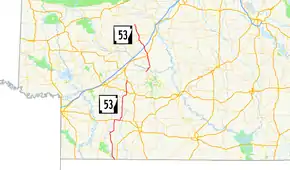
Highway 53 (AR 53, Ark. 53, and Hwy. 53) is a designation for two north–south state highways in Southwest Arkansas, United States. One route of 53.31 miles (85.79 km) begins at the Louisiana state line and runs north to US Highway 371 (US 371) south of Prescott. A second route of 32.55 miles (52.38 km) begins at Highway 24 and runs north through Gurdon to Highway 8. Both routes are maintained by the Arkansas State Highway and Transportation Department (AHTD).
| ||||
|---|---|---|---|---|
 | ||||
| Route information | ||||
| Maintained by ArDOT | ||||
| Section 1 | ||||
| Length | 27.09 mi[1] (43.60 km) | |||
| South end | Bradley Road at the Louisiana state line near State Line | |||
| North end | ||||
| Section 2 | ||||
| Length | 26.22 mi[1] (42.20 km) | |||
| South end | ||||
| North end | ||||
| Section 3 | ||||
| Length | 32.55 mi[1] (52.38 km) | |||
| South end | ||||
| Major junctions | ||||
| North end | ||||
| Location | ||||
| Counties | Clark, Lafayette, Nevada | |||
| Highway system | ||||
| ||||
Route description
History
Highway 53 was created during the 1926 Arkansas state highway numbering as a route between State Road 24 in eastern Nevada County and Gurdon. The route was extended from Gurdon north to Holly Grove on July 10, 1957, adding 11 miles (18 km).[2] Six years later, Highway 53 was extended from Holly Grove north to Hollywood, creating a new overlap with Highway 51, on April 24, 1963.[3] The highway was extended north for the last time from Hollywood to Highway 8 on June 23, 1965.[4]
Between September 1929 and March 1930, a second segment between and Bodcaw and State Road 19 (now US 371) was added to the state highway system.[5][6] The route was extended south from Bodcaw to Falcon on July 10, 1957,[7] and extended south to US 82 at Buckner on April 24, 1963.[8] A third section of Highway 53 was created in Lafayette County between the Louisiana state line and McKamie on March 7, 1961.[9][10] The gap between the two southern routes was closed two years later when Highway 53 was extended north from McKamie to US 82 Truck in Stamps on June 23, 1965.[11]
Major intersections
| County | Location | mi[1] | km | Destinations | Notes | ||
|---|---|---|---|---|---|---|---|
| Lafayette | | 0.00 | 0.00 | Bradley Road, Louisiana state line | Southern terminus; southern terminus of segment 5 | ||
| | 2.43– 7.28 | 3.91– 11.72 | |||||
| | 13.92 | 22.40 | Eastern terminus of AR 360 | ||||
| Mars Hill | 17.66 | 28.42 | Southern terminus of AR 313 | ||||
| Stamps | 27.09 | 43.60 | Begin US 82 overlap; northern terminus of segment 5 | ||||
| Gap in route | |||||||
| Buckner | 0.00 | 0.00 | End US 82 overlap; southern terminus of segment 4 | ||||
| Nevada | Falcon | 7.96– 8.06 | 12.81– 12.97 | ||||
| | 11.91– 14.09 | 19.17– 22.68 | |||||
| | 19.10 | 30.74 | |||||
| | 22.41 | 36.07 | Southern terminus of AR 73 | ||||
| | 24.84 | 39.98 | Western terminus of AR 372 | ||||
| | 25.96 | 41.78 | Begin AR 299 overlap | ||||
| | 26.22 | 42.20 | Northern terminus of segment 3 | ||||
| Gap in route | |||||||
| | 0.00 | 0.00 | Southern terminus of segment 2 | ||||
| Clark | Barringer | 4.94 | 7.95 | Southern terminus of AR 372 | |||
| Gurdon | 11.14 | 17.93 | Begin US 67 overlap; northern terminus of segment 1 | ||||
| | 0.00 | 0.00 | End US 67 overlap; southern terminus of segment 0 | ||||
| | 5.05 | 8.13 | Exit 63 (I-30) | ||||
| Holly Grove | 10.71– 11.53 | 17.24– 18.56 | Officially designated exception[lower-alpha 1] | ||||
| Hollywood | 14.52 | 23.37 | |||||
| | 21.41 | 34.46 | Northern terminus of segment 0 | ||||
1.000 mi = 1.609 km; 1.000 km = 0.621 mi
| |||||||
See also
Notes
- Map note for officially designated exception: EXCEPT.-0.88 MI. OVER S.H. 51 9.89-10.77[12]
References
- System Information and Research Division (2014). "Arkansas Road Log Database" (MDB). Arkansas State Highway and Transportation Department. Retrieved March 27, 2016.
- "Minutes" (1953–1969), p. 1780.
- "Minutes" (1953–1969), p. 913.
- "Minutes" (1953–1969), p. 671.
- Arkansas State Highway Commission (September 1, 1929). Map of the State of Arkansas Showing Types of Roads (TIF) (Map). Arkansas State Highway Commission. Retrieved November 18, 2016.
- Arkansas State Highway Commission (March 1930). Official Highway Service Map (TIF) (Map). Arkansas State Highway Commission. Retrieved November 18, 2016.
- "Minutes" (1953–1969), p. 1790.
- "Minutes" (1953–1969), p. 916.
- "Minutes" (1953–1969), pp. 1044–1045.
- "Minutes" (1953–1969), p. 1045.
- "Minutes" (1953–1969), p. 666.
- Arkansas State Highway and Transportation Department Planning and Research Division. Route and Section Map, Clark County, Arkansas (PDF) (Map). Arkansas State Highway and Transportation Department. Retrieved November 17, 2016.
- "Minutes of the Meeting" (PDF). Arkansas State Highway Commission. 1953–1969. Retrieved November 18, 2016.
External links
![]() Media related to Arkansas Highway 53 at Wikimedia Commons
Media related to Arkansas Highway 53 at Wikimedia Commons

