Arzenc-d'Apcher
Arzenc-d'Apcher is a commune in the Lozère department in southern France.
Arzenc-d'Apcher | |
|---|---|
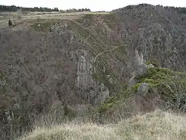 The Gorge of Bès, in Arzenc-d'Apcher | |
Location of Arzenc-d'Apcher 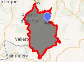
| |
 Arzenc-d'Apcher  Arzenc-d'Apcher | |
| Coordinates: 44°51′08″N 3°07′10″E | |
| Country | France |
| Region | Occitanie |
| Department | Lozère |
| Arrondissement | Mende |
| Canton | Peyre en Aubrac |
| Intercommunality | CC Hautes Terres Aubrac |
| Government | |
| • Mayor (2014-2020) | Jean-Marie Tardieu |
| Area 1 | 7.88 km2 (3.04 sq mi) |
| Population (2017-01-01)[1] | 50 |
| • Density | 6.3/km2 (16/sq mi) |
| Time zone | UTC+01:00 (CET) |
| • Summer (DST) | UTC+02:00 (CEST) |
| INSEE/Postal code | 48007 /48310 |
| Elevation | 760–1,137 m (2,493–3,730 ft) (avg. 1,100 m or 3,600 ft) |
| 1 French Land Register data, which excludes lakes, ponds, glaciers > 1 km2 (0.386 sq mi or 247 acres) and river estuaries. | |
Population
|
|
See also
References
- "Populations légales 2017". INSEE. Retrieved 6 January 2020.
| Wikimedia Commons has media related to Arzenc-d'Apcher. |
| Authority control |
|---|
This article is issued from Wikipedia. The text is licensed under Creative Commons - Attribution - Sharealike. Additional terms may apply for the media files.