Saint-Bonnet-de-Chirac
Saint-Bonnet-de-Chirac (French pronunciation: [sɛ̃ bɔnɛ də ʃiʁak]; Occitan: Sant Bonet) is a commune in the Lozère department in southern France.
Saint-Bonnet-de-Chirac | |
|---|---|
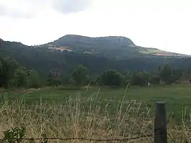 The Truc de Saint-Bonnet-de-Chirac at 942 m (3,091 ft) | |
Location of Saint-Bonnet-de-Chirac 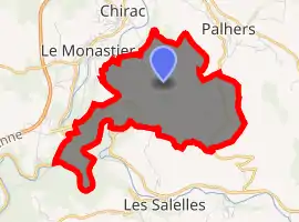
| |
 Saint-Bonnet-de-Chirac  Saint-Bonnet-de-Chirac | |
| Coordinates: 44°30′51″N 3°17′02″E | |
| Country | France |
| Region | Occitanie |
| Department | Lozère |
| Arrondissement | Mende |
| Canton | Bourgs sur Colagne |
| Intercommunality | Gévaudan |
| Government | |
| • Mayor (2020–2026) | Isabelle Recoulin |
| Area 1 | 7.68 km2 (2.97 sq mi) |
| Population (2017-01-01)[1] | 68 |
| • Density | 8.9/km2 (23/sq mi) |
| Time zone | UTC+01:00 (CET) |
| • Summer (DST) | UTC+02:00 (CEST) |
| INSEE/Postal code | 48138 /48100 |
| Elevation | 579–960 m (1,900–3,150 ft) (avg. 650 m or 2,130 ft) |
| 1 French Land Register data, which excludes lakes, ponds, glaciers > 1 km2 (0.386 sq mi or 247 acres) and river estuaries. | |
Geography
The Colagne forms part of the commune's south-western border, then flows into the Lot, which forms part of the commune's southern border.
See also
References
- "Populations légales 2017". INSEE. Retrieved 6 January 2020.
External links
| Wikimedia Commons has media related to Saint-Bonnet-de-Chirac. |
| Authority control |
|
|---|
This article is issued from Wikipedia. The text is licensed under Creative Commons - Attribution - Sharealike. Additional terms may apply for the media files.