Astaillac
Astaillac is a commune in the Corrèze department in the Nouvelle-Aquitaine region of central France.
Astaillac | |
|---|---|
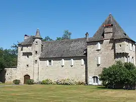 The Chateau of Estresse | |
.svg.png.webp) Coat of arms | |
Location of Astaillac 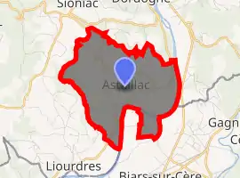
| |
 Astaillac  Astaillac | |
| Coordinates: 44°57′09″N 1°49′56″E | |
| Country | France |
| Region | Nouvelle-Aquitaine |
| Department | Corrèze |
| Arrondissement | Brive-la-Gaillarde |
| Canton | Midi Corrézien |
| Intercommunality | CC Midi Corrézien |
| Government | |
| • Mayor (2014-2020) | Bernard Reynal |
| Area 1 | 7.35 km2 (2.84 sq mi) |
| Population (2017-01-01)[1] | 232 |
| • Density | 32/km2 (82/sq mi) |
| Time zone | UTC+01:00 (CET) |
| • Summer (DST) | UTC+02:00 (CEST) |
| INSEE/Postal code | 19012 /19120 |
| Elevation | 128–306 m (420–1,004 ft) (avg. 202 m or 663 ft) |
| 1 French Land Register data, which excludes lakes, ponds, glaciers > 1 km2 (0.386 sq mi or 247 acres) and river estuaries. | |
The inhabitants of the commune are known as Astaillacois or Astaillacoises.[2]
Geography
Astaillac is located some 45 km south-east of Brive-la-Gaillarde and 15 km north by north-west of Saint-Céré. The eastern border of the commune is also the border between the departments of Corrèze and Lot. Access to the commune is by the D41 road from Beaulieu-sur-Dordogne in the north passing through the east of the commune and continuing south-west to Liourdres. The D41E1 comes from the D153E south-west of Sioniac through the commune to the village and continues to the hamlet of La Plaine. Apart from the village there are the hamlets of Conques, Le Soulie, La Plaine, and Cassagne. The commune is mixed forest and farmland.[3]
The Dordogne river forms the eastern border of the commune except for a small area on the left bank which forms part of the commune. The Dordogne flows south and eventually joins the Garonne at Saint-Seurin-de-Bourg. Several streams rise in the commune and flow south-east to join the Dordogne: the Ruisseau de Ganissal, the Ruisseau de Fontanille, the Ruisseau de Laborie, and the Ruisseau de Coucoulogne which forms the western border of the commune.[3]
Neighbouring communes and villages
Places adjacent to Astaillac | ||||||||||
|---|---|---|---|---|---|---|---|---|---|---|
| ||||||||||
Heraldry
Arms of Astaillac |
The official status of the blazon remains to be determined
Blazon: |
Administration
List of Successive Mayors[4]
| From | To | Name | Party | Position |
|---|---|---|---|---|
| 2001 | 2008 | Pierre Gaubet | ||
| 2008 | 2012 | Nicole Lescure | ||
| 2012 | 2020 | Bernard Reynal |
(Not all data is known)
Demography
In 2017 the commune had 232 inhabitants.
|
| ||||||||||||||||||||||||||||||||||||||||||||||||||||||||||||||||||||||||||||||||||||||||||||||||||||||||||||||||||
| Source: EHESS[5] and INSEE[6] | |||||||||||||||||||||||||||||||||||||||||||||||||||||||||||||||||||||||||||||||||||||||||||||||||||||||||||||||||||
Sites and monuments
See also
References
- "Populations légales 2017". INSEE. Retrieved 6 January 2020.
- Inhabitants of Corrèze (in French)
- Google Maps
- List of Mayors of France (in French)
- Données Cassini, EHESS
- Population en historique depuis 1968, INSEE
- Ministry of Culture, Mérimée PA00099657 Chateau of Estresse (in French)
- Ministry of Culture, Palissy PM19000011 Bronze Bell (in French)
External links
- Astaillac on the old IGN website (in French)
- Astaillac on Géoportail, National Geographic Institute (IGN) website (in French)
- Astaillac on the 1750 Cassini Map
| Wikimedia Commons has media related to Astaillac. |
| Authority control |
|---|