Saint-Étienne-aux-Clos
Saint-Étienne-aux-Clos is a commune in the Corrèze department in central France.
Saint-Étienne-aux-Clos | |
|---|---|
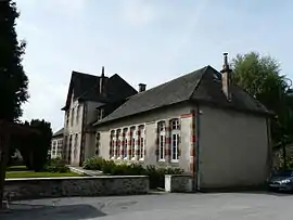 The town hall and school in Saint-Étienne-aux-Clos | |
.svg.png.webp) Coat of arms | |
Location of Saint-Étienne-aux-Clos 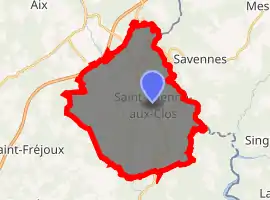
| |
 Saint-Étienne-aux-Clos  Saint-Étienne-aux-Clos | |
| Coordinates: 45°34′10″N 2°27′40″E | |
| Country | France |
| Region | Nouvelle-Aquitaine |
| Department | Corrèze |
| Arrondissement | Ussel |
| Canton | Haute-Dordogne |
| Intercommunality | Haute-Corrèze Communauté |
| Government | |
| • Mayor (2020–2026) | Alain Lanly |
| Area 1 | 34.78 km2 (13.43 sq mi) |
| Population (2017-01-01)[1] | 229 |
| • Density | 6.6/km2 (17/sq mi) |
| Time zone | UTC+01:00 (CET) |
| • Summer (DST) | UTC+02:00 (CEST) |
| INSEE/Postal code | 19199 /19200 |
| Elevation | 555–793 m (1,821–2,602 ft) (avg. 750 m or 2,460 ft) |
| 1 French Land Register data, which excludes lakes, ponds, glaciers > 1 km2 (0.386 sq mi or 247 acres) and river estuaries. | |
Geography
The Chavanon forms most of the commune's eastern boundary.
Population
| Year | Pop. | ±% |
|---|---|---|
| 1962 | 257 | — |
| 1968 | 278 | +8.2% |
| 1975 | 228 | −18.0% |
| 1982 | 203 | −11.0% |
| 1990 | 198 | −2.5% |
| 1999 | 211 | +6.6% |
| 2008 | 234 | +10.9% |
See also
References
- "Populations légales 2017". INSEE. Retrieved 6 January 2020.
| Wikimedia Commons has media related to Saint-Étienne-aux-Clos. |
| Authority control |
|---|
This article is issued from Wikipedia. The text is licensed under Creative Commons - Attribution - Sharealike. Additional terms may apply for the media files.