Naves, Corrèze
Naves is a commune in the Corrèze department in the Nouvelle-Aquitaine region in central France.
Naves | |
|---|---|
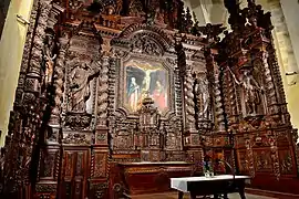 The carved wooden altar, in Saint Peter's Church | |
.svg.png.webp) Coat of arms | |
Location of Naves 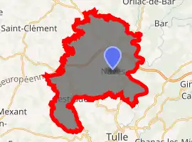
| |
 Naves  Naves | |
| Coordinates: 45°18′50″N 1°46′00″E | |
| Country | France |
| Region | Nouvelle-Aquitaine |
| Department | Corrèze |
| Arrondissement | Tulle |
| Canton | Naves |
| Government | |
| • Mayor (2014–2020) | Christophe Jerretie |
| Area 1 | 35.93 km2 (13.87 sq mi) |
| Population (2017-01-01)[1] | 2,320 |
| • Density | 65/km2 (170/sq mi) |
| Time zone | UTC+01:00 (CET) |
| • Summer (DST) | UTC+02:00 (CEST) |
| INSEE/Postal code | 19146 /19460 |
| Elevation | 222–505 m (728–1,657 ft) |
| 1 French Land Register data, which excludes lakes, ponds, glaciers > 1 km2 (0.386 sq mi or 247 acres) and river estuaries. | |
Geography
Naves's territory is crossed by the Corrèze, Solane, Vigne, Vimbelle, and Céronne rivers.
History
Situated on the crossroad of two importants Roman ways, Naves of Latin Navea (fertile valley), was established in Gallo-Roman period, in this time the village included temples, theater and many other monuments.
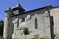 St. Peter's Church.
 Baptistry.
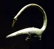 Gaulish helmet found in Tintignac.
- Altarpiece of St. Peter's Church.
Naves is now growing, thanks to the arrival in 2002 of the A89 linking Lyon to Bordeaux. Since 2000, the people pouring into the town which knows a growth rate of 13% over the past ten years. They are mostly active youth mostly working in Tulle.
Population
|
| ||||||||||||||||||||||||||||||||||||||||||||||||||||||||||||||||||||||||||||||||||||||||||||||||||||||||||||||||||
| Source: EHESS[2] and INSEE[3] | |||||||||||||||||||||||||||||||||||||||||||||||||||||||||||||||||||||||||||||||||||||||||||||||||||||||||||||||||||
See also
References
- "Populations légales 2017". INSEE. Retrieved 6 January 2020.
- Données Cassini, EHESS
- Population en historique depuis 1968, INSEE
| Wikimedia Commons has media related to Naves (Corrèze). |
| Authority control |
|---|
This article is issued from Wikipedia. The text is licensed under Creative Commons - Attribution - Sharealike. Additional terms may apply for the media files.
