Atlas van Loon
The Atlas van Loon was commissioned by Frederik Willem van Loon of Amsterdam. It consists of a large number of maps published between 1649 and 1676:[1]
- Volumes I to IX: The Dutch edition of Joan Blaeu's Atlas Maior (Grooten Atlas) of 1663-1665
- Volumes X, XI and XII: Blaeu's city books of Italy, covering the Papal States, Rome, Naples, and Sicily, all of 1663.
- Volumes XIII and XIV: Two volumes of the French edition of Blaeu's Atlas Maior, covering France and Switzerland, both of 1663.
- Volumes XV and XVI: Blaeu's Toonneel der Steeden, city books covering both the Northern and the Southern Netherlands, of 1649
- Volume XVII: Pieter Goos's Zee-atlas ofte water-wereld (Maritime Atlas or Water World) of 1676
- Volume XVIII: The French edition of Johannes Janssonius's Zeeatlas (Maritime Atlas) of 1657
.jpg.webp)
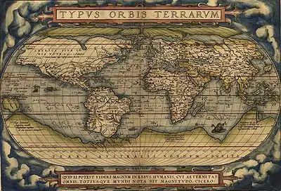
Blaeu's world map, first published in the 1664 volume of the Atlas van Loon, later reprinted
The Atlas van Loon was acquired by the Nederlands Scheepvaartmuseum in 1996.
References
External links
| Wikimedia Commons has media related to Atlas van Loon. |
- Digitalized maps and pictures from the Atlas Van Loon:
- Volume I: Atlas Maior I - Northern and Eastern Europe
- Volume II: Atlas Maior II - Germany and Central Europe
- Volume III: Atlas Maior III - the Low Countries
- Volume IV: Atlas Maior IV - England and Wales
- Volume V: Atlas Maior V - Scotland and Ireland
- Volume VI: Atlas Maior VI - France
- Volume VII: Atlas Maior VII - Italy and Greece
- Volume VIII: Atlas Maior VIII - Spain, Portugal, Africa and America
- Volume IX: Atlas Maior IX - Asia
- Volume X: Italian Cities I - the Papal State
- Volume XI: Italian Cities II - Rome
- Volume XII: Italian Cities III - Naples and Sicily
- Volume XIII: French edition Atlas Maior VII - France
- Volume XIV: French edition Atlas Maior VIII - France and Switzerland
- Volume XV: Tooneel der Steeden I - cities and fortifications of the Dutch Republic
- Volume XVI: Tooneel der Steeden II - cities and fortifications of the Spanish Netherlands
- Volume XVII: Goos' Zee-atlas ofte water-wereld
- Volume XVIII: Janssonius' Zeeatlas
This article is issued from Wikipedia. The text is licensed under Creative Commons - Attribution - Sharealike. Additional terms may apply for the media files.