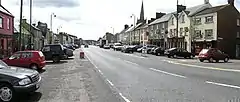
Aughnacloy, County Tyrone
Aughnacloy, sometimes spelt Auchnacloy (Irish: Achadh na Cloiche (field of the stone)[1]) is a village in County Tyrone, Northern Ireland. Close to the border with County Monaghan in the Republic of Ireland, the village is about 20 km southwest of Dungannon, and 7 km southeast of Ballygawley. It is situated in the historic barony of Dungannon Lower and the civil parish of Carnteel.[2] In the 2001 Census it had a population of 801.
Aughnacloy
| |
|---|---|
 | |
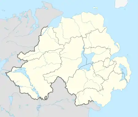 Location within Northern Ireland | |
| Population | 1,015 (2011 Census) |
| Irish grid reference | H665521 |
| • Belfast | 52 mi (84 km) |
| District | |
| County | |
| Country | Northern Ireland |
| Sovereign state | United Kingdom |
| Post town | AUGHNACLOY |
| Postcode district | BT69 |
| Dialling code | 028, +44 28 |
| UK Parliament | |
| NI Assembly | |
History
Much of the town was built in the 18th Century by Acheson Moore, the local landlord. Because he backed the Jacobite cause, he planted his estate in the shape of a thistle and planned out the town on the edge of it. Unable to rename it "Mooretown", he had to settle for naming the main street "Moore Street", and the side streets Sydney, Lettice, and Henrietta (now Ravella Road), after his three wives.
Aughnacloy served as an important staging post on the road to Derry. However, lacking large-scale industry, it started to wane in the late 19th century.
The Troubles
On 20 January 1974, Cormac McCabe (42), the first Headmaster of Aughnacloy Secondary School and a Captain in the Ulster Defence Regiment (UDR), was shot dead by the Provisional Irish Republican Army (IRA). His corpse was found in a field near Aughnacloy.[3]
On 6 July 1977, David Morrow (37) a Royal Ulster Constabulary (RUC) officer, was killed by the IRA while sitting in a stationary RUC patrol car in Aughnacloy.[4]
In 1988, Aidan McAnespie, a Catholic civilian, was killed, in contested circumstances, by a bullet from a general purpose machine-gun held by a British Army soldier at Aughnacloy. In June 2008, the Police Service of Northern Ireland Historical Enquiries Team published its findings on the case in a report. In the fatal shooting the soldier claimed that his hands were wet, causing him to accidentally fire the machine-gun. The report called this the "least likely version" of what happened.[5]
Buildings and features of note
- One of the widest Main Streets in Northern Ireland
- The Aughnacloy Thistle (large scale landscape feature)
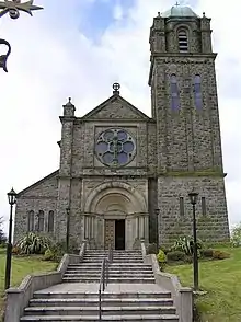
- St James Parish Church
- Aughnacloy Market House
- Copperfields Nursing home (former Alms House)
Transport
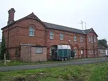
Aughnacloy had its own railway station on the Clogher Valley Railway (CVR) from 2 May 1887 to 1 January 1942.[6] The CVR's headquarters and locomotive workshop was also at Aughnacloy. Current proposals to upgrade the A5 road through the village to a dual carriageway and build a bypass have met with a mixed reaction in the town, with many traders and farmers strongly opposed.
Education
- Aughnacloy Primary School
- Aughnacloy College (former names: Aughnacloy Secondary School; Aughnacloy High School) opened in 1963, designed by John MacGeagh. It occupies a rural site on the outskirts of Aughancloy, serving a catchment area stretching along the Blackwater valley including Caledon, Greystone, Innismagh, Ballygawley, Lisdoart and Favour Royal
- St. Mary's Primary School, Aughnacloy
Demography
Aughnacloy is classified as a Small Village or Hamlet by the Northern Ireland Statistics and Research Agency (NISRA)] (i.e. with population between 500 and 1,000 people).[7]
On the census date (29 April 2001), there were 801 people living in Aughnacloy. Of these:
- 23.3% were aged under 16 years and 26.6% were aged 60 and over;
- 48.6% of the population were male and 51.4% were female;
- 45.4% were from a Catholic background and 52.1% were from a Protestant background; and,
- 3.0% of people aged 16–74 were unemployed.[7]
On the census date (27 March 2011), there were 1,015 people living in Aughnacloy. Of these:
- 23.44% were aged under 16 years and 16.08% were aged 60 and over;
- 49.86% of the population were male and 50.14% were female;
- 56.84% were from a Catholic background and 41.34% were from a Protestant background; and,
- 56.76% were in paid employment
- 4.93% of people aged 16–74 were unemployed.[7]
Sport
- Aghaloo O'Neills – Gaelic Athletic Association club.
- Aughnacloy Golf Club – one of the founder clubs of the Golfing Union of Ireland in 1890; reformed in 1994 and currently based at Lissenderry just outside the village
- Aughnacloy Races – The ancient tradition of horse racing has been re-established in recent years
See also
References
- "Aughnacloy". Place Names NI. Retrieved 18 March 2013.
- "Townlands of County Tyrone". IreAtlas Townland Database. Retrieved 28 December 2012.
- "An Index of Deaths from the Conflict in Ireland". NI Conflict Archive on the Internet. Retrieved 13 August 2011.
- "An Index of Deaths from the Conflict in Ireland". NI Conflict Archive on the Internet. Retrieved 13 August 2011.
- "Checkpoint death report welcomed". BBC News NI. 24 June 2008. Retrieved 24 June 2008.
- "Aughnacloy station" (PDF). Railscot – Irish Railways. Archived (PDF) from the original on 26 September 2007. Retrieved 9 September 2007.
- Northern Ireland Statistics and Research Agency (NISRA)
Sources
| Wikimedia Commons has media related to Aughnacloy, County Tyrone. |
- Dungannon & South Tyrone Area Plan 2010