Bedford Historic District (Bedford, Virginia)
Bedford Historic District is a national historic district located at Bedford, Virginia. The district encompasses 208 contributing buildings in two residential neighborhoods of Bedford, known locally as the Old Avenel area and the Longwood Avenue area.
Bedford Historic District | |
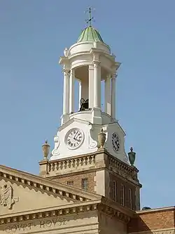 Bedford County Court House cupola, April 2005 | |
  | |
| Location | Roughly bounded by Longwood, Bedford, and Mountain Aves., Peaks, Oak, Grove, and Washington Sts., Bedford, Virginia |
|---|---|
| Coordinates | 37°20′15″N 79°31′21″W |
| Area | 105 acres (42 ha) |
| Architect | Multiple |
| Architectural style | Greek Revival, Late Victorian, Federal |
| NRHP reference No. | 84000031[1] |
| VLR No. | 141-0073 |
| Significant dates | |
| Added to NRHP | October 4, 1984 |
| Designated VLR | August 21, 1984[2] |
The buildings are in a variety of 19th- and early 20th-century architectural styles. Notable buildings include Chestnut, Winthrop, the Thomas L. Leftwich House, Liberty Presbyterian Church (1844), John Wharton House (1848), Burks-Guy House (1884), Charles W. Wharton House (now the Bedford Children's Library), the Harrison Building (1878), George L. Colgate House (1892), Bedford Masonic Hall (1895), Citizens Bank Building (Bedford, Virginia), Bedford High School (1928), Bedford County Courthouse (1930), Bedford Elementary School (1912), Main Street Methodist Church (1880s), and St. John's Episcopal Church (1923). Avenel (1836) and the John D. Ballard House (1915) are separately listed.[3]
The District was listed on the National Register of Historic Places in 1984.[1]
See also
- National Elks Home in Bedford, Virginia
References
- "National Register Information System". National Register of Historic Places. National Park Service. July 9, 2010.
- "Virginia Landmarks Register". Virginia Department of Historic Resources. Archived from the original on 21 September 2013. Retrieved 5 June 2013.
- Virginia Historic Landmarks Commission Staff (August 1984). "National Register of Historic Places Inventory/Nomination: Bedford Historic District" (PDF). Archived from the original (PDF) on 2013-08-13. and Accompanying photo and Accompanying map