Bi'ina
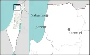
Bi'ina or al-Bi'na[2] (also el-Baneh) is an Arab town in the Northern District of Israel. It is located east of Akko. In 2003, Bi'ina merged with Majd al-Krum and Deir al-Asad to form the city of Shaghur, but was reinstated as a local council in 2008 after Shaghur was dissolved. Bi'ina has a mostly Muslim population (92%) with a small Christian minority (8%);[3] in 2019 its population was 8,381.[1]
Bi'ina
| |
|---|---|
 Bi'ina  Bi'ina | |
| Coordinates: 32°55′46″N 35°16′22″E | |
| Grid position | 175/259 PAL |
| Country | |
| District | Northern |
| Population (2019)[1] | |
| • Total | 8,381 |
History
Classical antiquity
Along with several other sites, Bi'ina was proposed as the location of ancient Beth-Anath mentioned in Egyptian and biblical texts.[4][Note 1] Archaeological evidence suggests that Bi'ina, though perhaps occupied in the Early Bronze Age, was no longer occupied in the Late Bronze Age.[7] Among the place names found in a list of Ramses II, Beth-anath remains the only name that clearly refers to the Galilee according to Judges 1:33.[8]
The old site of Bi'ina is thought to have been at the mound of Jelamet el-Bi'ina, less than a mile southeast of the present site of Bi'ina.[9] The word jélameh, meaning "hill, mound," is sometimes employed instead of tell.
Ottoman Empire
In 1517, Bi'ina, with the rest of Palestine, was incorporated into the Ottoman Empire after it was captured from the Mamluks, and by 1596 appeared in tax registers as belonging to the Nahiya of Akka, part of Safad Sanjak. It had a population of 61 households; 46 Muslim and 15 Christian. The villagers paid a fixed tax rate of 25% on various agricultural products, including wheat, barley, olives, cotton, goats or beehives, in addition to for a press for grapes or olives; a total of 7,134 akçe.[10][11]
A map from Napoleon's invasion of 1799 by Pierre Jacotin showed the place, named as "El Bena",[12] while in 1838, el Ba'neh was noted as Greek Christian village in the Esh-Shagur district, located between Safad, Acca and Tiberias.[13]
In 1875 Victor Guérin noted that the population was divided between Druze and Greek Orthodox Christians. He listed a mosque and a Greek church, both of which were built on the sites of older churches.[14] In the late 19th century, it was described as a village of 300 Muslims and 100 Christians, surrounded by olives and arable land. Water was supplied by a spring.[15] A sarcophagus was also seen lying outside the town.
Lieutenant Kitchener of the Palestine Exploration Fund described the town under its name El-Baneh, and where he noted a spring and birket (reservoir).[16]
A population list from about 1887 showed that B'aneh had 620 inhabitants; slightly more Muslims than Greek Catholic Christians.[17]
British Mandate
In the 1922 census of Palestine conducted by the British Mandate authorities, Al Ba'na had a population of 518; 311 Muslims and 207 Christians,[18] where all the Christians were Orthodox.[19] By the 1931 census the population had increased to 651; 441 Muslims and 210 Christians, in a total of 133 houses.[20]
In the 1945 statistics, Bi'ina had 830 inhabitants; 530 Muslims and 300 Christians.[21] They owned 14,839 dunams of land, while 57 dunams were public.[21][22] 1,619 dunams were plantations and irrigable land, 5,543 used for cereals,[21][23] while 57 dunams were built-up (urban) land.[21][24]
Israel
During Operation Hiram, 29–31 October 1948, the village surrendered to the advancing Israeli army. Many of the villagers fled north but some remained and were not expelled.[25] The village remained under Martial Law until 1966.
In 1981, a Bedouin neighborhood was created in the village, populated by members of the Sawaed tribe from Rame. In 2001, the village was spread out over an area of some 30 dunams (7.4 acres).[26]
In 2014 and in 2016, archaeological survey-excavations were conducted at the site by Alexander Yarde and Alexander Efron on behalf of the Israel Antiquities Authority (IAA).[27]
Notable residents
Notes
- Those who dispute Albright's identification are Charles William Meredith van de Velde and Victor Guérin, who place the ancient site of Beth-anath in Ain Aata, Lebanon. Others place the ancient site in Bu'eine Nujeidat, while still others thought that Beth-anath ought to be identified with Safad el Batih in Lebanon.[5] Klein thought that Beth-anath was to be identified with Hinah.[6] Zvi Gal, in his article, "The Late Bronze Age in Galilee: A Reassessment," Bulletin of the American Schools of Oriental Research, No. 272 (Nov., 1988), pp. 79-84 writes: "Various sites have been suggested for this city: Bi'ina in the Beit Hakerem Valley, (Albright 1923: 19-20; Safrai & Safrai 1976), Ba'inah in the Beit Netophah Valley (Alt 1946: 55-57), Tel Roš (Amiran 1953: 125-26), and Tell el Ḥirbeh (Garstang 1931:244-45)."
References
- "Population in the Localities 2019" (XLS). Israel Central Bureau of Statistics. Retrieved 16 August 2020.
- from personal name, according to Palmer, 1881, p. 41
- בענה 2014
- W.F. Albright was a major proponent of this view (AASOR - 1921/1922, pp. 19–20). As for the Egyptian texts that mention Beth-Anath, see the Zenon Papyri. Cf. Stephen G. Wilson & Michel Desjardins, Text and Artifact in the Religions of Mediterranean Antiquity: Essays in honour of Peter Richardson, Canadian Corporation for Studies in Religion: Wilfrid Laurier University Press, Waterloo Ontario 2000, p. 121, ISBN 0-88920-356-3
- Shmuel Ahituv, Canaanite Toponyms in Ancient Egyptian Documents, Magnes Press: Jerusalem 1984 ISBN 9652235644, citing Aharoni (1957:70-74).
- Klein, S. (1934), pp. 5–7
- Gal, 1988, pp. 80–83
- See p. 82 in: Gal, Zvi (1988). "The Late Bronze Age in Galilee: A Reassessment". Bulletin of the American Schools of Oriental Research. 272 (Nov): 79–84. doi:10.2307/1356788. JSTOR 1356788., and where the copyist erroneously cited Joshua 1:33, instead of Judges 1:33.
- Albright (1923), p. 19
- Hütteroth and Abdulfattah, 1977, p. 191
- Note that Rhode, 1979, p. 6 writes that the register that Hütteroth and Abdulfattah studied from the Safad-district was not from 1595/6, but from 1548/9
- Karmon, 1960, p. 166.
- Robinson and Smith, 1841, vol. 3, 2nd appendix, p. 133
- Guérin, 1880, p. 445, as translated by Conder and Kitchener, 1881, SWP I, p. 150
- Conder and Kitchener, 1881, SWP I, p. 150
- Conder and Kitchener, 1881, SWP I, p. 150
- Schumacher, 1888, p. 174
- Barron, 1923, Table XI, Sub-district of Acre, p. 36
- Barron, 1923, Table XVI, p. 50
- Mills, 1932, p. 100
- Government of Palestine, Department of Statistics, 1945, p. 4
- Government of Palestine, Department of Statistics. Village Statistics, April, 1945. Quoted in Hadawi, 1970, p. 40
- Government of Palestine, Department of Statistics. Village Statistics, April, 1945. Quoted in Hadawi, 1970, p. 80
- Government of Palestine, Department of Statistics. Village Statistics, April, 1945. Quoted in Hadawi, 1970, p. 130
- Morris, 1987, p. 226
- Frankel, et al. (2001), p. 22
- Israel Antiquities Authority, Excavators and Excavations Permit for Year 2014, Survey Permit # A-7169; Excavators and Excavations Permit for Year 2016, Survey Permit # A-7632
Bibliography
- Aharoni, Y. (1957). The Settlement of the Tribes of Israel in the Upper Galilee. Jerusalem: Magnes Press.
- Albright, W.F. (1922). "Contribution to the Historical Geography of Palestine". The Annual of the American Schools of Oriental Research. 2–3: 1–46.
- Albright, W.F. (1923). Warren J. Moulton (ed.). "Beth Anath". The Annual of the American Schools of Oriental Research (AASOR). New Haven: Yale University Press. 2–3. JSTOR 3768450.
- Barron, J.B., ed. (1923). Palestine: Report and General Abstracts of the Census of 1922. Government of Palestine.
- Conder, C.R.; Kitchener, H.H. (1881). The Survey of Western Palestine: Memoirs of the Topography, Orography, Hydrography, and Archaeology. 1. London: Committee of the Palestine Exploration Fund. (p. 153)
- Frankel, Rafael; Getzov, Nimrod; Aviam, Mordechai; Degani, Avi (2001). "Settlement Dynamics and Regional Diversity in Ancient Upper Galilee (Archaeological Survey of Upper Galilee)". Israel Antiquities Authority. 14.
- Gal, Zvi (1988). "The Late Bronze Age in Galilee: A Reassessment". Bulletin of the American Schools of Oriental Research. 272 (272): 79–84. doi:10.2307/1356788. JSTOR 1356788.
- Government of Palestine, Department of Statistics (1945). Village Statistics, April, 1945.
- Guérin, V. (1880). Description Géographique Historique et Archéologique de la Palestine (in French). 3: Galilee, pt. 1. Paris: L'Imprimerie Nationale. (Deir al-Asad: p. 446, Majd al-Kurum: pp 437, 444)
- Hadawi, S. (1970). Village Statistics of 1945: A Classification of Land and Area ownership in Palestine. Palestine Liberation Organization Research Center.
- Hütteroth, Wolf-Dieter; Abdulfattah, Kamal (1977). Historical Geography of Palestine, Transjordan and Southern Syria in the Late 16th Century. Erlanger Geographische Arbeiten, Sonderband 5. Erlangen, Germany: Vorstand der Fränkischen Geographischen Gesellschaft. ISBN 978-3-920405-41-4.
- Karmon, Y. (1960). "An Analysis of Jacotin's Map of Palestine" (PDF). Israel Exploration Journal. 10 (3, 4): 155–173, 244–253.
- Klein, S. (1934). "Notes on History of Large Estates in Palestine". Yediot - Bulletin of the Jewish Palestine Exploration Society. 1: 18–34.
- Mills, E., ed. (1932). Census of Palestine 1931. Population of Villages, Towns and Administrative Areas. Jerusalem: Government of Palestine.
- Morris, B. (1987). The Birth of the Palestinian Refugee Problem. Cambridge University Press. ISBN 978-0-521-33028-2.
- Palmer, E.H. (1881). The Survey of Western Palestine: Arabic and English Name Lists Collected During the Survey by Lieutenants Conder and Kitchener, R. E. Transliterated and Explained by E.H. Palmer. Committee of the Palestine Exploration Fund.
- Pringle, Denys (1993). The Churches of the Crusader Kingdom of Jerusalem: A-K (excluding Acre and Jerusalem). Cambridge University Press. ISBN 9780521390361. (p.80 -92 )
- Rhode, H. (1979). Administration and Population of the Sancak of Safed in the Sixteenth Century (PhD). Columbia University.
- Robinson, E.; Smith, E. (1841). Biblical Researches in Palestine, Mount Sinai and Arabia Petraea: A Journal of Travels in the year 1838. 3. Boston: Crocker & Brewster.
- Röhricht, R. (1893). (RRH) Regesta regni Hierosolymitani (MXCVII-MCCXCI) (in Latin). Berlin: Libraria Academica Wageriana. (p. 188 no 674; p. 248 no 934; p. 256 no 974; p. 308 no 1175)
- Safrai, Z. (1976). "Beth-Anath". Sinai. 78: 18–34.
- Schumacher, G. (1888). "Population list of the Liwa of Akka". Quarterly Statement - Palestine Exploration Fund. 20: 169–191.
External links
- Welcome To Bi'na
- Survey of Western Palestine, Map 3: IAA, Wikimedia commons
.svg.png.webp)
